
Hybrid spatial indexing mechanism for processing geographic text Skyline query

A technology of indexing and text similarity, applied in the fields of electronic digital data processing, special data processing applications, instruments, etc.

Active Publication Date: 2018-05-18
NANJING UNIV OF AERONAUTICS & ASTRONAUTICS
View PDF8 Cites 15 Cited by
  • Summary
  • Abstract
  • Description
  • Claims
  • Application Information

AI Technical Summary

Problems solved by technology

[0014] The purpose of the present invention is to propose a hybrid spatial index mechanism for processing geographic text Skyline queries, and is committed to effectively organizing and storing data sets containing both keyword text information and spatial location information and performing Skyline queries on the data sets problem, on the premise of ensuring clear structure and reasonable storage space, improve query efficiency

Method used


Image

  • Hybrid spatial indexing mechanism for processing geographic text Skyline query
  • Hybrid spatial indexing mechanism for processing geographic text Skyline query
  • Hybrid spatial indexing mechanism for processing geographic text Skyline query

Examples


Embodiment Construction

[0071] The technical solution of the present invention will be described in further detail below in conjunction with accompanying drawings and examples of implementation:

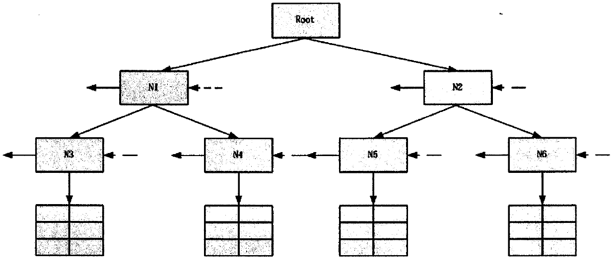
[0072] 1. The initial state of the R* tree is an empty root node, and the node threshold of the current R* tree is set to 3 (the maximum number of child nodes or data points contained in the index tree does not exceed 3);

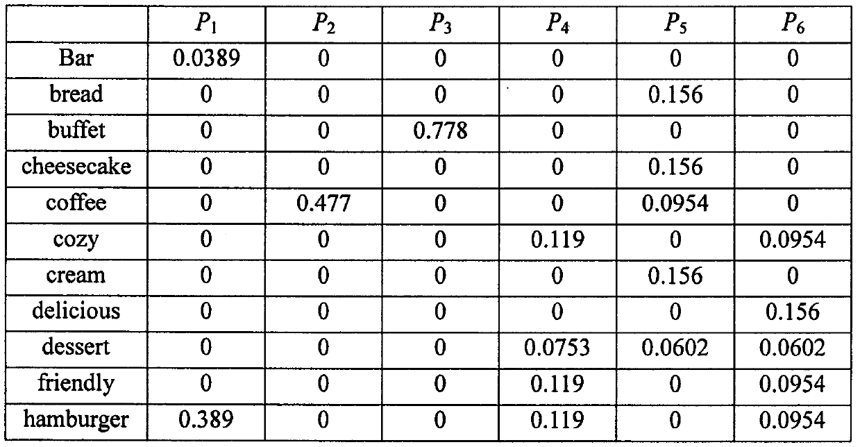
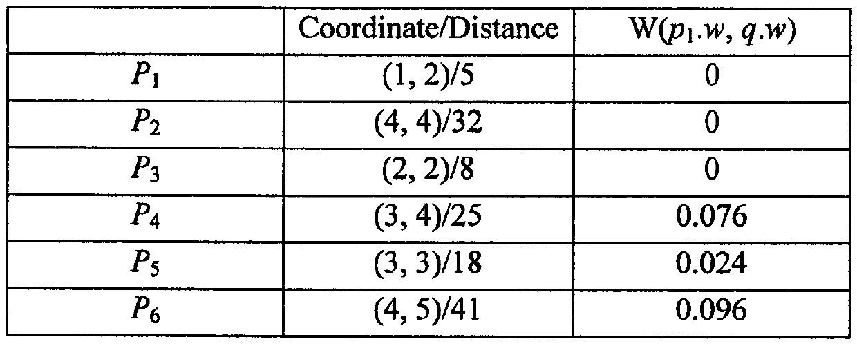
[0073] 2. Traverse the data collection {p 1 ,p 2 ,p 3 ,p 4 ,p 5 ,p 6}, first call the Choose Path strategy, respectively p 1 ,p 2 ,p 3 Insert into the IMR*-T tree structure, the number of data points in the current node reaches the upper limit critical value, then insert p 4 After that, the node overflows at this time (since there is only one leaf node in the IMR*-T tree at this time, all 4 nodes will be inserted into the same leaf node);

[0074] 3. Use the Pick Irrelevant strategy to select some data points for reinsertion. First, sort the 4 data points into {p 1 ,p 3 ,p 4 ...


PUM


Abstract

The invention provides a hybrid spatial indexing mechanism for processing geographic text Skyline query, wherein geographic text Skyline query refers to performing Skyline query on a geographic text information dataset. Data points in the geographic text dataset include geographic position information and keyword text information. The Inverted-Merged R*-Tree (IMR*-T) integrates the R*tree and theInverted File thought, and the invention belongs to the query indexing field in computer science. The invention focuses on solution of the problem of storing the geographic text dataset and performingSkyline query on the geographic text dataset, can improve the Skyline query efficiency on the premise of ensuring reasonable storage. The invention constructs a multi-branch tree according to data point spatial position distribution by means of an R* tree construction strategy, and can construct an Inverted File for leaf nodes of the tree. To improve the clipping efficiency of the dataset, tree nodes store boundary frame information. The invention is widely suitable for relevant application scenarios of geographic text Skyline query.

Description

technical field [0001] The present invention relates to a hybrid spatial indexing mechanism for processing geographic text Skyline queries, in particular to the effective organization and storage of data sets containing keyword text attributes and geographic spatial position attributes and the Skyline query for the data sets, which belongs to the field of computer science Query index fields. Background technique [0002] With the rapid development of social networks, a large amount of data (Geo-TextualData) with text keyword tags is generated. For example, the personal Weibo status posted by the user on Sina Weibo (with geographic location and Weibo label information), the restaurant information posted by the restaurant on the Meituan app (with the restaurant’s geographic location information, discount information, and menu information). Wait). These data mainly contain two dimensions of information: geographic location information and keyword information. For the geograp...

Claims


Application Information

Patent Timeline
IPC IPC(8): G06F17/30
CPCG06F16/322
Inventor 郑吉平张智明张丝曼
Owner NANJING UNIV OF AERONAUTICS & ASTRONAUTICS
Learn More