Determination method for optimal segmentation result of remote sensing image by fusing multiple quantitative evaluation indexes

A technology of remote sensing image and quantitative evaluation, applied in the field of remote sensing image processing

Active Publication Date: 2018-05-18
HENAN POLYTECHNIC UNIV
View PDF3 Cites 9 Cited by
  • Summary
  • Abstract
  • Description
  • Claims
  • Application Information

AI Technical Summary

Problems solved by technology

[0004] The purpose of the present invention is to provide a method for determining the optimal segmentation result of remote sensing images that integrates multiple quantitative evaluation indicators, which can overcome the uncertainty caused by the evaluation of a single index in the determination of the optimal segmentation results of remote sensing images in the existing remote sensing images, and improve the quality of remote sensing images. Objectivity, practicability and reliability of image segmentation results

Method used


Image

  • Determination method for optimal segmentation result of remote sensing image by fusing multiple quantitative evaluation indexes
  • Determination method for optimal segmentation result of remote sensing image by fusing multiple quantitative evaluation indexes
  • Determination method for optimal segmentation result of remote sensing image by fusing multiple quantitative evaluation indexes

Examples


Embodiment Construction

[0044] The technical solutions of the present invention will be clearly and completely described below in conjunction with the accompanying drawings. Apparently, the described embodiments are only some of the embodiments of the present invention, not all of them. Based on the embodiments of the present invention, all other embodiments obtained by persons of ordinary skill in the art without making creative efforts belong to the protection scope of the present invention.

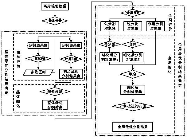
[0045] Such as figure 1 As shown, a method for determining the optimal segmentation result of a remote sensing image fused with multiple quantitative evaluation indicators according to the present invention comprises the following steps in turn:

[0046] (1) Image segmentation: Process the high-resolution remote sensing data to obtain remote sensing images of the study area, and perform image segmentation on the remote sensing images to obtain a segmentation result set.

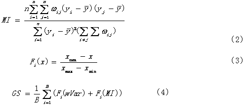
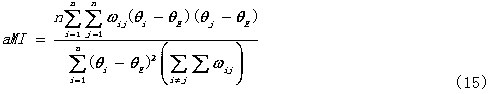
[0047] (2) Overall evaluation: calc...


PUM


Abstract

The invention discloses a determination method for an optimal segmentation result of a remote sensing image by fusing multiple quantitative evaluation indexes. The method comprises the steps that firstly, the remote sensing image is subjected to image segmentation, and a segmentation result set is obtained; then, a GS value of the segmentation result set is calculated, and a scale interval parameter of a remote sensing image segmentation parameter is determined; an E value of the segmentation result set is calculated by using the scale interval parameter, and a primary optimal segmentation result set is determined according to the E value; then, the primary optimal segmentation result set is subjected to fusion segmentation according to the corresponding segmentation parameter, an overalloptimal segmentation result of the remote sensing image is determined, and an under-segmentation object set, an over-segmentation object set and a reservation segmentation object set are screened out;finally, the three object sets are combined, evaluation is conducted by using an improved GS value, and the global optimal segmentation result is determined. According to the determination method, the uncertainty problem caused by single index evaluation in existing determination of the optimal segmentation result of the remote sensing image can be solved, and the objectivity, practicability andreliability of the segmentation result of the remote sensing image are improved.

Description

technical field [0001] The invention relates to the technical field of remote sensing image processing, in particular to a method for determining optimal segmentation results of remote sensing images by fusing multiple quantitative evaluation indexes. Background technique [0002] With the continuous increase and improvement of high-resolution remote sensing platforms, more and more high-resolution remote sensing data are widely used in land remote sensing monitoring, natural disaster monitoring, agricultural monitoring and ecological restoration and other industries. Due to the advantages of high spatial resolution, high definition, rich information and strong timeliness of data, high-resolution remote sensing data can obtain more details such as structure, shape and texture of ground features while obtaining rich spectral information of ground features. information, making it possible to observe the detailed changes of the surface on a smaller spatial scale. The tradition...

Claims


Application Information

Patent Timeline
Patent Type & Authority Applications(China)
IPC IPC(8): G06T7/11G06T7/00
CPCG06T7/0002G06T2207/10032G06T2207/20016G06T7/11
Inventor 程结海王建如
Owner HENAN POLYTECHNIC UNIV
Why Eureka
Try Eureka