Robot synchronous positioning and map construction method and system

A technology of map construction and simultaneous positioning, which is applied in the directions of instruments, 3D modeling, image enhancement, etc., and can solve the problem of less research on line segment features

Active Publication Date: 2018-05-29
上海阅面网络科技有限公司
View PDF6 Cites 35 Cited by
  • Summary
  • Abstract
  • Description
  • Claims
  • Application Information

AI Technical Summary

Problems solved by technology

[0005] In addition to point features, line segment features are also a relatively important

Method used


Image

  • Robot synchronous positioning and map construction method and system
  • Robot synchronous positioning and map construction method and system
  • Robot synchronous positioning and map construction method and system

Examples


Embodiment Construction

[0059]In order to make the purpose, technical solutions and advantages of the present application clearer, the present application will be further described in detail below with reference to the accompanying drawings and examples.

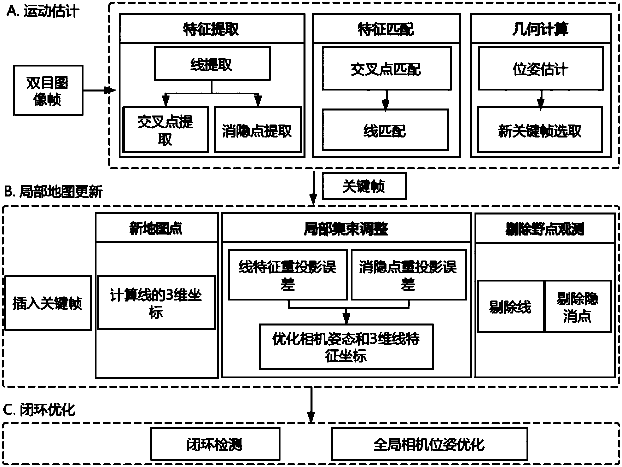
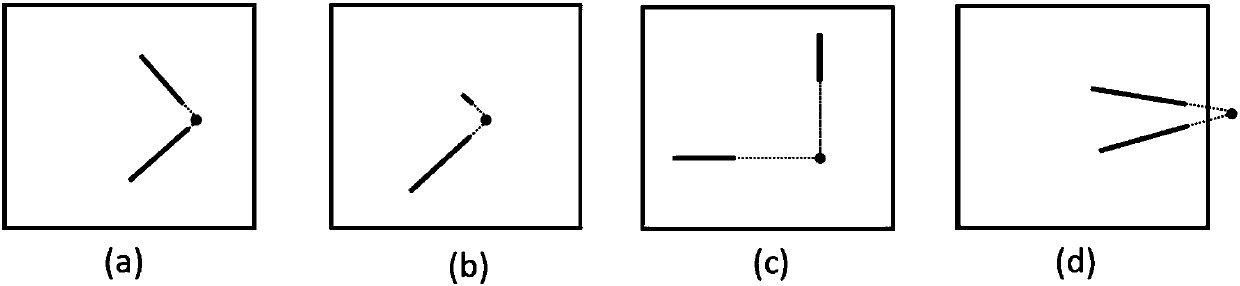
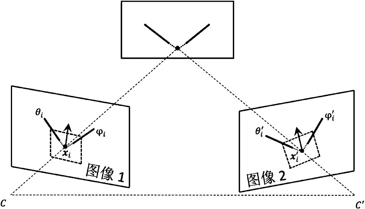
[0060] The invention proposes a method for synchronous positioning and map construction based on line segment features and line segment blanking points. Simultaneous localization and mapping (simultaneous localization and mapping) mentioned in the present invention, referred to as SLAM, refers to: the robot starts from an unknown location in an unknown environment and observes map features (for example, Point features, line segment features, etc.) to position itself, and then build a map incrementally according to its own position, so as to achieve the purpose of simultaneous positioning and map construction. The vanishing point mentioned in the present invention, also called vanishing point or vanishing point, refers to the intersection point of a...


PUM


Abstract

The invention discloses a robot synchronous positioning and map construction method based on line segment features and line segment vanishing points, and the robot synchronous positioning and map construction method is applied to the positioning and map construction of a robot in an unknown environment. The robot synchronous positioning and map construction method comprises the steps of: extracting line segment features, intersection points and vanishing points from images, establishing line segment matching between the images according to the intersection points, estimating camera poses according to line segment matching results, and selecting a new keyframe; and inserting the keyframe into a map, calculating three-dimensional coordinates of the newly-added line segment features, performing cluster adjustment on local map, and removing outlier observation; and performing closed-loop detection and global map optimization based on the intersection points. The invention further discloses a synchronous positioning and map construction system. The robot synchronous positioning and map construction method and the robot synchronous positioning and map construction system can be appliedto the positioning and map construction of the robot in the unknown environment, and is particularly suitable for structured or semi-structured scenes, such as indoor environments, outdoor environments with buildings, and the like.

Description

technical field [0001] The present invention relates to the field of navigation technology of intelligent robots, and more specifically to simultaneous localization and mapping (SLAM) technology, and relates to a method of establishing a map based on line segment features and line segment blanking points, and based on the established map. Method and system for positioning. Background technique [0002] Among various autonomous mobile robot systems, simultaneous localization and mapping (SLAM) systems play an important role. In the way that does not require modification of the environment, the current SLAM mainly includes lidar-based solutions and vision sensor-based solutions. The visual sensor generally includes a monocular camera, a binocular camera, a combination of multiple cameras, and the like. [0003] The SLAM solution based on lidar is relatively mature, and it has the advantages of high precision, easy implementation, and less interference from external light sou...

Claims


Application Information

Patent Timeline
IPC IPC(8): G06T17/05G06T7/246G06T7/536G06T7/73G01C21/00
CPCG01C21/005G06T17/05G06T2207/10016G06T2207/30244G06T7/246G06T7/536G06T7/73
Inventor 赵季贺一家丁小羽赵京雷
Owner 上海阅面网络科技有限公司
Why Eureka
Try Eureka