A spatial optimization method for urban video surveillance based on sign-in poi
A technology of video monitoring and optimization method, which is applied in the field of geographic information and space optimization, can solve the problems of multi-monitoring blind spots, high coverage overlap rate of monitoring cameras, and does not consider the influence of monitoring subject factors and monitoring camera parameter factors, etc., to reduce monitoring Effects of blind spots, reduction of overlap rate and occlusion rate, and improvement of monitoring coverage
- Summary
- Abstract
- Description
- Claims
- Application Information
AI Technical Summary
Problems solved by technology
Method used
Image

Examples
Embodiment 1
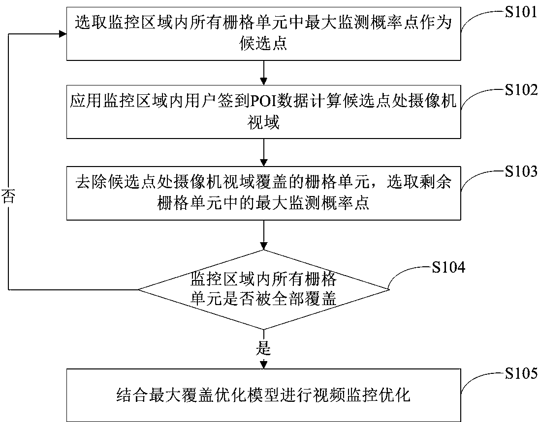
[0056] Such as figure 1 Shown, a kind of city video monitoring space optimization method based on check-in POI of the present invention comprises the following steps:
[0057] Step S101: Select the point with the highest probability of being monitored among all the grid units in the monitoring area as a candidate point.
[0058] Step S102: Applying the POI data logged in by the user in the monitoring area to calculate the camera field of view at the candidate point.
[0059] Step S103: Remove the grid cells covered by the camera field of view at the candidate points, and select the points with the highest probability of being monitored in the remaining grid cells.
[0060] Step S104: Determine whether all the grid units in the monitoring area are completely covered, if not, proceed to step S101; if yes, proceed to the next step.
[0061] Step S105: Perform video surveillance optimization in combination with the maximum coverage optimization model.
Embodiment 2
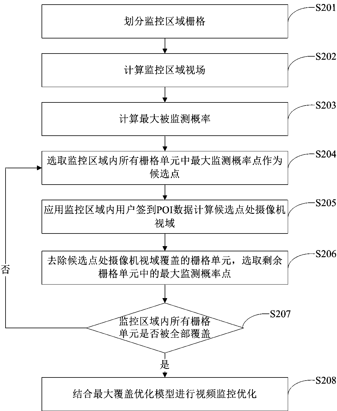
[0063] Such as figure 2 As shown, another urban video surveillance space optimization method based on check-in POIs of the present invention includes the following steps: Step S201: dividing the monitoring area grid:
[0064] According to the scope of the monitoring area and the area occupied by the building, a grid unit with a fixed size is selected, and the monitoring area is spatially discretized, divided into grid units with a fixed size, and the grids covered by the building are eliminated.
[0065] Step S202: Calculate the field of view of the monitoring area:
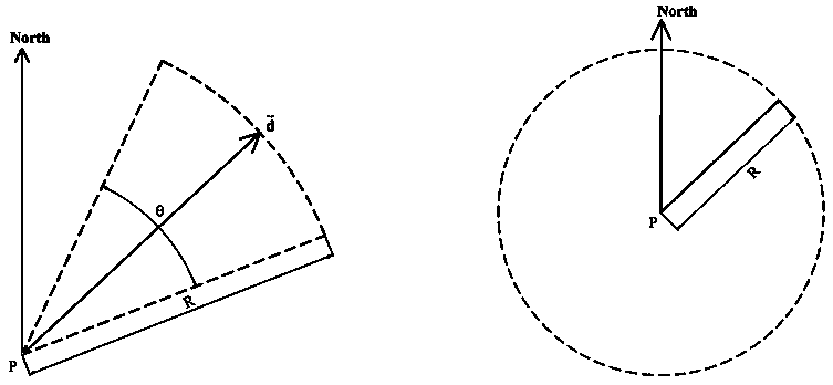
[0066] Taking each grid unit in the monitoring area as a viewpoint, apply the field of view analysis method to calculate the field of view range of each grid unit; as an implementable method, apply the Line of Sight (LOS) field of view analysis method to calculate The field of view range of each grid cell.
[0067] Step S203: Calculate the maximum probability of being monitored:
[0068] According to the calc...
Embodiment approach
[0101] As an implementable mode, the GLPK optimizer is used to optimize the solution;
[0102] Step S2084: Evaluation of video surveillance optimization scheme:
[0103] Select the three indicators of coverage rate, overlap rate and occlusion rate to evaluate and analyze the optimization results; combine the evaluation results to form the final video surveillance deployment and surveillance camera selection plan;
[0104] The view coverage rate is defined as the ratio of the coverage area after camera view fusion to the area of the monitoring area; the overlap rate is defined as the ratio of the sum of the view area areas of all deployed cameras to the area of view area after fusion; the occlusion rate is defined as the camera view area The ratio of the area blocked by the building to the area of the fused field of view.
[0105] As a possible implementation method, select the check-in POI data of the blocks between Hanjiang Road, Changjiang Road, Huainan Street, and Un...
PUM
 Abstract
Description
Claims
Application Information
 - R&D
- Intellectual Property
- Life Sciences
- Materials
- Tech Scout
- Unparalleled Data Quality
- Higher Quality Content
- 60% Fewer Hallucinations
Browse by: Latest US Patents, China's latest patents, Technical Efficacy Thesaurus, Application Domain, Technology Topic, Popular Technical Reports.
© 2025 PatSnap. All rights reserved.Legal|Privacy policy|Modern Slavery Act Transparency Statement|Sitemap|About US| Contact US: help@patsnap.com