UAV 3D scene path navigation platform and its 3D improved path planning method

A three-dimensional scene and path navigation technology, applied in the field of navigation, can solve the problems of long algorithm time, no UAV attitude information, inability to dynamically display the UAV obstacle avoidance process, etc., to achieve the effect of short time consumption

Active Publication Date: 2021-06-22
NANJING UNIV OF SCI & TECH
View PDF0 Cites 0 Cited by
  • Summary
  • Abstract
  • Description
  • Claims
  • Application Information

AI Technical Summary

Problems solved by technology

The algorithm takes a relatively long time, and the obtained path is only a space curve, which does not contain the attitude information of the UAV, and cannot dynamically display the obstacle avoidance process of the UAV.

Method used


Image

  • UAV 3D scene path navigation platform and its 3D improved path planning method
  • UAV 3D scene path navigation platform and its 3D improved path planning method
  • UAV 3D scene path navigation platform and its 3D improved path planning method

Examples


Embodiment 1

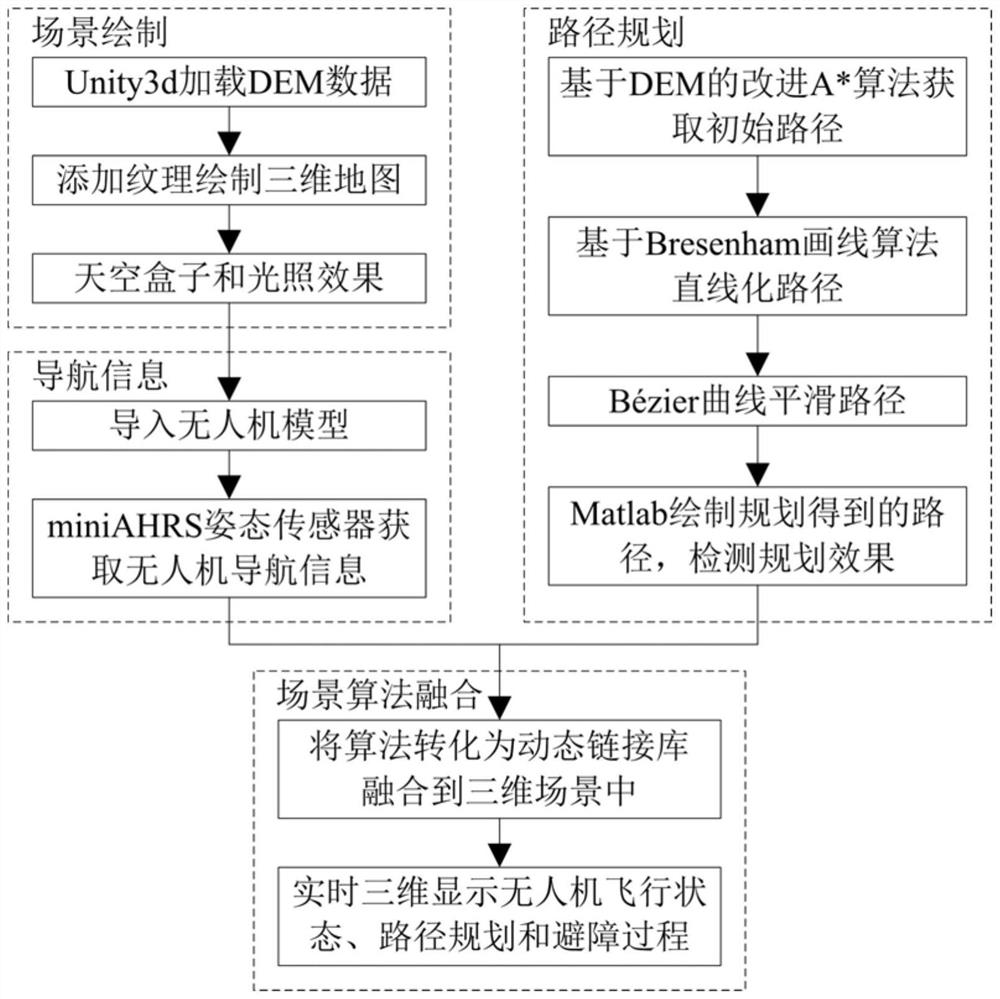
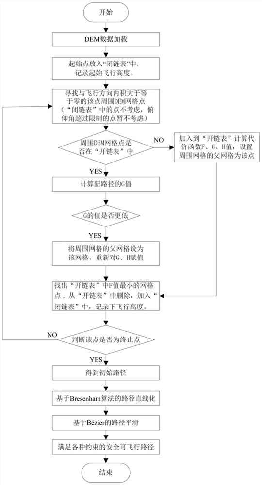
[0078] Such as Figure 1~6 As shown, a UAV 3D path navigation platform loads DEM map data based on Unity3d to display 3D scenes; through VS2010C++ programming, a 3D improved path planning algorithm based on DEM is realized to obtain a safe flight path for UAVs. And use Matlab2012a to draw and plan the results of path detection and planning; import the UAV model, and combine the miniAHRS attitude sensor to obtain the current UAV flight attitude; integrate the path planning algorithm into the 3D scene, and analyze the flight status and obstacle avoidance of the UAV Real-time three-dimensional display of the process;

[0079] A three-dimensional path navigation platform for unmanned aerial vehicles such as figure 1 The steps shown are implemented.

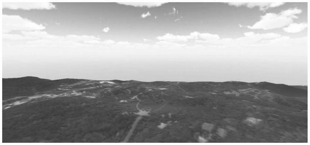
[0080] Step 1. Scene drawing: Unity3d loads DEM data, adds corresponding map texture information to DEM, and adds skybox and lighting effects. Such as figure 2 As shown, the three-dimensional scene is realistically displayed. St...


PUM


Abstract

The invention discloses a UAV three-dimensional scene path navigation platform and a three-dimensional improved path planning method thereof. The platform loads DEM map data based on Unity3d to display three-dimensional scenes; through VS2010C++ programming, the three-dimensional improved path planning based on DEM is realized Algorithm to obtain the safe flight path of the UAV, and use Matlab2012a to draw and plan the path detection planning effect; import the UAV model and combine the miniAHRS attitude sensor to obtain the current UAV navigation information; integrate the path planning algorithm into the 3D scene , Real-time three-dimensional display of UAV flight status and obstacle avoidance process. The three-dimensional improved path planning method obtains the initial path through the improved A* algorithm based on DEM; combines the Bresenham straight line generation algorithm to linearize the obtained preliminary planning path; and then performs Bézier curve smoothing optimization on the linearized path. The invention takes short time for path planning, can display the flight state in real time, and dynamically displays the path planning and obstacle avoidance process in three dimensions.

Description

technical field [0001] The invention relates to the technical field of navigation, in particular to a three-dimensional scene path navigation platform for an unmanned aerial vehicle and a three-dimensional improved path planning method thereof. Background technique [0002] Digital elevation map (Digital Elevation Map), referred to as DEM. It is a solid ground model that expresses the ground elevation in the form of a set of ordered numerical arrays. It is a data set of the plane coordinates of regular grid points within a certain range and their elevation or latitude and longitude. With the rapid development of a series of high-tech technologies such as satellite technology and sensor technology, the resolution of DEM digital elevation data is getting higher and higher, which lays a good foundation for the application of DEM data. DEM has a wide range of applications in surveying and mapping, hydrology, meteorology, geomorphology, geology, soil, engineering construction, c...

Claims


Application Information

Patent Timeline
Patent Type & Authority Patents(China)
IPC IPC(8): G01C21/20
CPCG01C21/20
Inventor 白宏阳梁华驹苏文杰李成美郭宏伟胡福东孙瑞胜傅健
Owner NANJING UNIV OF SCI & TECH
Why Eureka
Try Eureka