Image marking method for streetscape video, terminal device and storage medium

An image tagging and street view technology, applied in image analysis, image data processing, structured data retrieval, etc., can solve the problems of difficult tagging and poor display effect of street view maps, and achieve the effect of improving display effect and speed

Inactive Publication Date: 2018-07-06
深圳市数字城市工程研究中心 +1
View PDF5 Cites 6 Cited by
  • Summary
  • Abstract
  • Description
  • Claims
  • Application Information

AI Technical Summary

Problems solved by technology

[0004] The purpose of the present invention is to provide a street view video image tagging method, terminal equipment and storage medium, through t

Method used


Image

  • Image marking method for streetscape video, terminal device and storage medium
  • Image marking method for streetscape video, terminal device and storage medium
  • Image marking method for streetscape video, terminal device and storage medium

Examples


Embodiment Construction

[0053] In order to make the object, technical solution and advantages of the present invention clearer, the present invention will be further described in detail below in conjunction with the accompanying drawings and embodiments. It should be understood that the specific embodiments described here are only used to explain the present invention, not to limit the present invention.

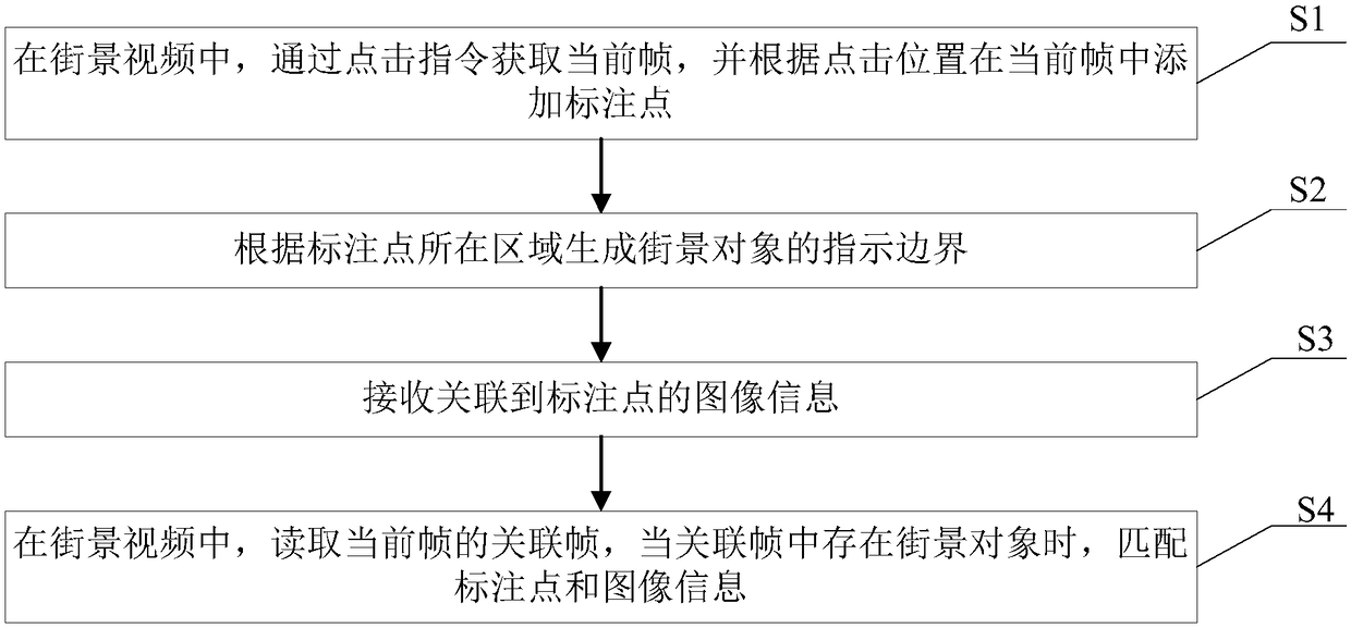
[0054] figure 1 An embodiment of the image tagging method for street view video of the present invention is shown. In this embodiment, the image tagging method of the Street View video includes:

[0055] In step S1, in the street view video, the current frame is acquired through a click instruction, and a marked point is added in the current frame according to the click position.

[0056] In step S1, when the street view video is played through the display screen, a click operation of clicking the display screen by the user is received, a click instruction is generated according to the click oper...


PUM


Abstract

The invention discloses an image marking method for a streetscape video, a terminal device and a storage medium. The method comprises the steps of obtaining a current frame through a clicking instruction in the streetscape video, and adding a marking point to the current frame according to a clicking position; according to a region where the marking point is located, generating an indication boundary of a streetscape object; receiving image information associated to the marking point; and in the streetscape video, reading an associated frame of the current frame, and when the streetscape object exists in the associated frame, matching the marking point and the image information. The streetscape video is output frame by frame, so that the tensile deformation is not required, the problem ofunsmooth linkage between images does not exist, and the display effect is improved. Furthermore, the marking point and the image information associated with the marking point are dynamically added tothe streetscape object in the current frame, and the marking point and the image information are matched to the corresponding streetscape object in the associated frame, so that the marking speed andthe streetscape object coverage degree are improved.

Description

technical field [0001] The invention relates to the technical field of electronic maps, in particular to an image labeling method for street view video, a terminal device and a storage medium. Background technique [0002] Street view map is a real-world map service that mainly provides users with 360-degree panoramic images of cities, streets or other environments. Users can obtain an immersive map browsing experience through this service. Through the street view map, as long as you sit in front of the computer, you can actually see the high-definition scene on the street. Realize the map browsing experience of "human perspective", and provide users with map services that are more realistic, accurate, and richer in picture details. [0003] However, when displaying street view maps through panoramic images, there are not only problems such as easy stretching and deformation of the image quality, unsmooth links between panoramic images, but also the problem that street view...

Claims


Application Information

Patent Timeline
IPC IPC(8): G06F17/30G06T7/181G06T7/70
CPCG06F16/29G06T7/181G06T7/70
Inventor 修文群
Owner 深圳市数字城市工程研究中心
Why Eureka
Try Eureka