
A spatial feature detection method and system

A technology of spatial features and detection methods, applied in the field of spatial detection, can solve problems such as confusion, inconspicuous spatial structure features, and inability to extract linear features, so as to achieve the effect of accurate extraction.

Active Publication Date: 2020-06-30
INST OF MINERAL RESOURCES CHINESE ACAD OF GEOLOGICAL SCI
View PDF5 Cites 0 Cited by
  • Summary
  • Abstract
  • Description
  • Claims
  • Application Information

AI Technical Summary

Problems solved by technology

And because the geological structure is reflected in the remote sensing image in a polygonal form, for example, a large structure reflects a large linear structure width, while a small structure reflects a small linear structure width, so the spatial structure characteristics of the structure are not obvious
In addition, linear features such as bridges and dams are also easily confused with structural features. Therefore, linear features are often not extracted in places with structures, and linear features are extracted in places without structures, and there are many linear features that cannot be selected.

Method used


Image

  • A spatial feature detection method and system
  • A spatial feature detection method and system
  • A spatial feature detection method and system

Examples


Embodiment Construction

[0066] The following will clearly and completely describe the technical solutions in the embodiments of the present invention with reference to the accompanying drawings in the embodiments of the present invention. Obviously, the described embodiments are only some, not all, embodiments of the present invention. Based on the embodiments of the present invention, all other embodiments obtained by persons of ordinary skill in the art without making creative efforts belong to the protection scope of the present invention.

[0067] The purpose of the present invention is to provide a spatial feature detection method and system, which can define the spatial features from two aspects of direction and linear features, so as to accurately extract the features of the target object.

[0068] In order to make the above objects, features and advantages of the present invention more comprehensible, the present invention will be further described in detail below in conjunction with the accom...


PUM


Abstract

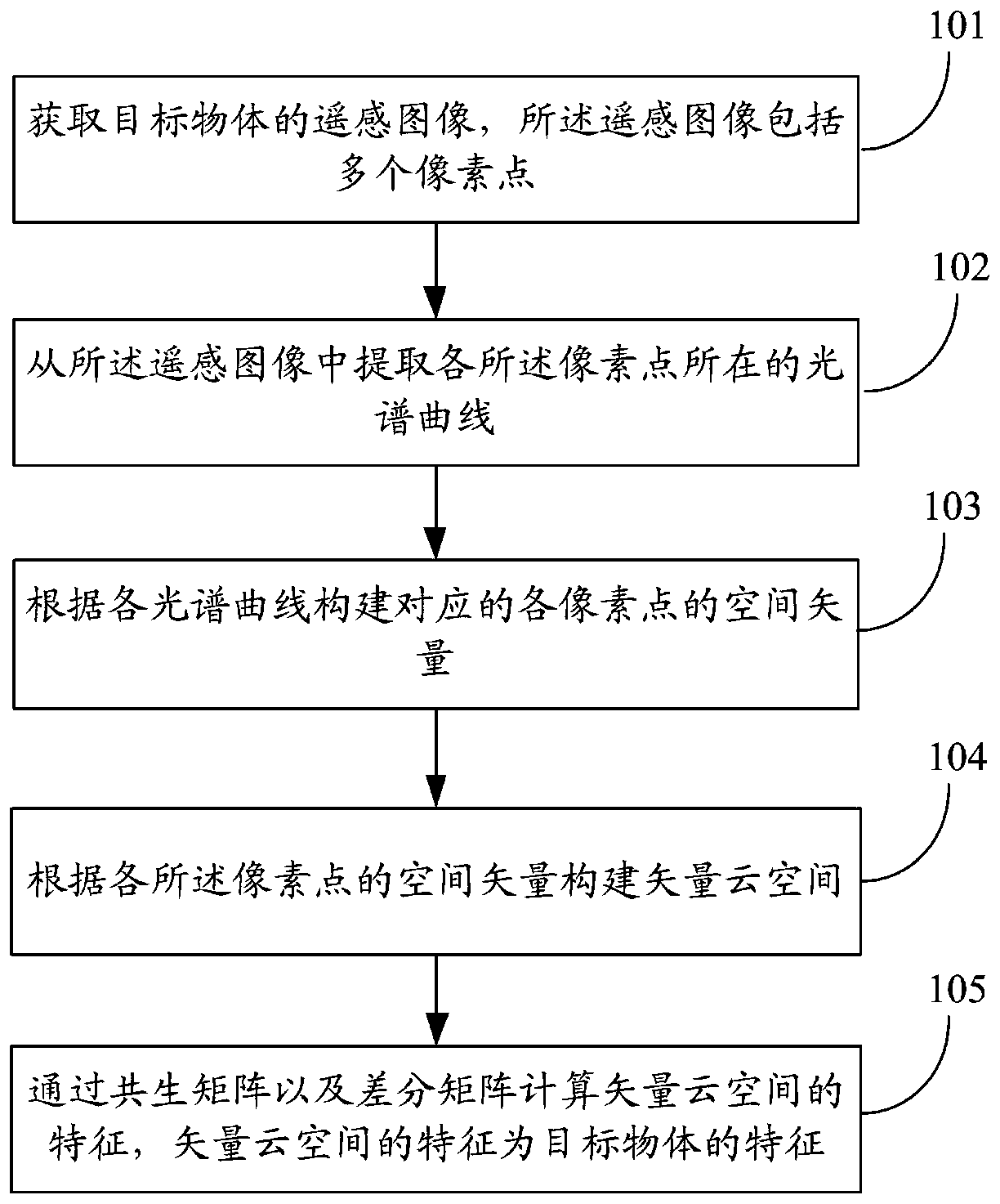
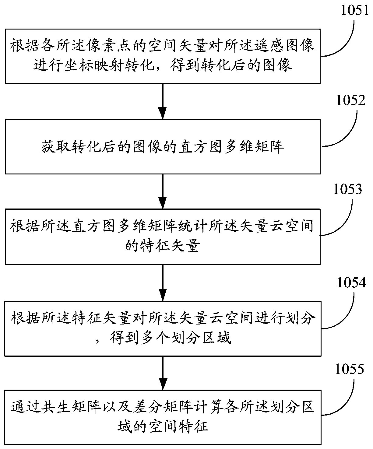
The invention discloses a spatial feature detection method and system. The method includes: acquiring a remote sensing image of a target object, the remote sensing image including a plurality of pixel points; extracting a spectral curve where each pixel point is located from the remote sensing image; the abscissa of the spectral curve represents the wavelength of the pixel point And the ordinate of the spectral curve represents the reflectivity of the pixel point; the corresponding space vector of each pixel point is constructed according to each spectral curve; the vector cloud space is constructed according to the space vector of each of the pixel points; calculated by the co-occurrence matrix and the difference matrix The feature of the vector cloud space, the feature of the vector cloud space is the feature of the target object. The present invention defines spatial features from two aspects of direction and linear features, so as to accurately extract the features of the target object.

Description

technical field [0001] The invention relates to the field of space detection, in particular to a space feature detection method and system. Background technique [0002] Spatial detection technology is often used in ground object classification, target detection and other aspects. Commonly used spatial detection technologies include neighborhood detection technology, linear feature extraction technology, etc. Existing spatial detection techniques only deal with the neighborhood problem of one reflectance value for each point in the image. Especially for the extraction of spatial linear features, for example, common feature extraction such as geological survey, highway detection, pipeline detection and other dangerous feature detection or texture classification is unsatisfactory. And because the geological structure is reflected in the remote sensing image in a polygonal form, for example, a large structure reflects a large linear structure width, while a small structure re...

Claims


Application Information

Patent Timeline
Patent Type & Authority Patents(China)
IPC IPC(8): G06K9/00G06K9/46G06K9/62
CPCG06V20/194G06V20/176G06V10/58G06V10/50G06V10/751
Inventor 姚佛军刘成林焦鹏程吴胜华耿新霞
Owner INST OF MINERAL RESOURCES CHINESE ACAD OF GEOLOGICAL SCI
Learn More