PPP-RTK positioning method based on low-orbit constellation navigation augmentation system

A PPP-RTK, low-orbit constellation technology, applied in the field of satellite navigation, can solve the problems of high station density requirements, low dynamic users, and difficulty in meeting high-precision real-time positioning requirements for ground-based monitoring networks.

Active Publication Date: 2018-08-17
BEIJING FUTURE NAVIGATION TECH CO LTD
View PDF6 Cites 42 Cited by
  • Summary
  • Abstract
  • Description
  • Claims
  • Application Information

AI Technical Summary

Problems solved by technology

[0003] In order to reduce the influence of atmospheric delay error on initialization, some scholars have proposed a PPP positioning method that takes into account atmospheric delay constraints, using the delay generated by the ionospheric model as observation constraint information to improve the calculation performance, and the initialization time can be further shortened to 15 minutes, but It is still difficult to meet the high-precision real-time positioning requirements
In order to reduce the convergence time, at present, the ground-based augmentation system broadcasts non-difference comprehensive correction information to correct the corresponding errors at the rover, so as to achieve the rapid separation of ambiguity parameters and position parameters, and the ambiguity parameters can be fixed within several epochs. However, the ground-based monitoring network has high requirements for station density, and is often suitable for low-dynamic users.

Method used


Image

  • PPP-RTK positioning method based on low-orbit constellation navigation augmentation system
  • PPP-RTK positioning method based on low-orbit constellation navigation augmentation system
  • PPP-RTK positioning method based on low-orbit constellation navigation augmentation system

Examples


Embodiment Construction

[0035] Exemplary embodiments of the present application will be described in more detail below with reference to the accompanying drawings. Although exemplary embodiments of the present disclosure are shown in the drawings, it should be understood that the present application may be embodied in various forms and should not be limited to the embodiments set forth herein. Rather, these embodiments are provided so that the present disclosure can be more thoroughly understood, and will fully convey the scope of the application to those skilled in the art.

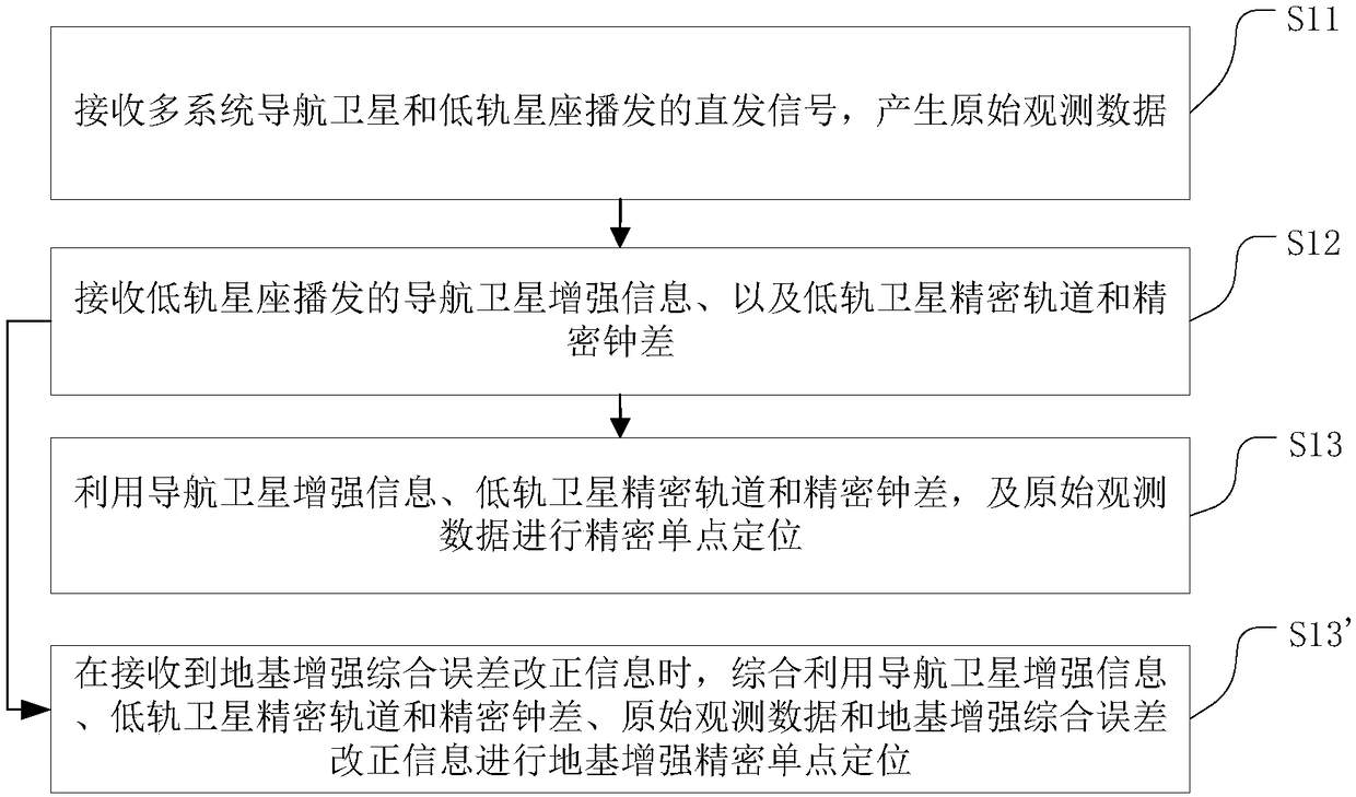
[0036] figure 1 A method flow chart of a PPP-RTK positioning method based on a low-orbit constellation navigation augmentation system according to an embodiment of the present invention is shown. see figure 1 The PPP-RTK positioning method based on the low-orbit constellation navigation enhancement system provided by the embodiment of the present invention specifically includes the following steps:

[0037] S11. Receive dire...


PUM


Abstract

The invention provides a PPP-RTK positioning method based on a low-orbit constellation navigation augmentation system. The method includes the steps that direct transmission signals broadcasted by multi-system navigation satellites and low-orbit constellations are received to generate original observation data; navigation satellite augmentation information broadcasted by the low-orbit constellations and low-orbit satellite precise orbits and precise clock difference are received; precise point positioning is conducted by utilizing the navigation satellite augmentation information, the low-orbit satellite precise orbits and precise clock differences and the original observation data; or, when ground-based augmentation comprehensive error correction information is received, ground-based augmentation precise point positioning is conducted by comprehensively utilizing the navigation satellite augmentation information, the low-orbit satellite precise orbits and precise clock difference, theoriginal observation data and the ground-based augmentation comprehensive error correction information. By means of the method, near-real-time precise positioning, velocity measuring and timing results can be obtained in the globe, real-time centimeter-level positioning, velocity measuring and timing results can be obtained in ground-based augmentation regions, and seamless switching between ground-based augmentation regions and non-ground-based augmentation regions of the global region can be achieved.

Description

technical field [0001] The invention relates to satellite navigation technology, in particular to a satellite navigation precision positioning, speed measurement and timing method. Background technique [0002] The initialization and re-initialization of navigation satellite precision point positioning (PPP) takes a long time (more than 30 minutes) which is the main factor limiting the application of this technology in the field of fast and real-time dynamic high precision. In order to shorten the initialization time and improve the positioning accuracy, the integer ambiguity fixing technology has been proposed and developed in recent years. The global monitoring network calculates and releases the satellite phase fractional deviation correction number in real time, and the user recovers the integer of the non-difference ambiguity by applying the deviation correction number characteristics, and then use the existing mature technology to fix the ambiguity of the whole circle....

Claims


Application Information

Patent Timeline
Patent Type & Authority Applications(China)
IPC IPC(8): G01S19/44G01S19/37
CPCG01S19/37G01S19/44G01S19/46G01S19/52G01S19/073G01S19/071G01S19/115G01S19/425G01S19/23
Inventor 穆旭成
Owner BEIJING FUTURE NAVIGATION TECH CO LTD
Why Eureka
Try Eureka