Automatic reconstruction method of multi-point statistical 3D geological model based on local search strategy

A three-dimensional geological and local search technology, applied in computing, 3D modeling, instruments, etc., can solve the problems of difficulty in ensuring the spatial continuity of reconstruction results, the limitation of calculation efficiency of multi-point statistical reconstruction methods, etc., and achieve the reduction of fixed search templates And the size should not be too large to ensure reliability and improve simulation efficiency

Active Publication Date: 2021-05-28
CHINA UNIV OF GEOSCIENCES (WUHAN)
View PDF4 Cites 0 Cited by
  • Summary
  • Abstract
  • Description
  • Claims
  • Application Information

AI Technical Summary

Problems solved by technology

Existing multi-point statistical reconstruction methods for global search and matching of all known data are also limited by their computational efficiency
However, it is difficult to ensure the spatial continuity of the reconstruction results in different directions in the whole space by using multi-point statistical techniques to simulate two-dimensional slices to gradually fill the three-dimensional space domain.

Method used


Image

  • Automatic reconstruction method of multi-point statistical 3D geological model based on local search strategy
  • Automatic reconstruction method of multi-point statistical 3D geological model based on local search strategy
  • Automatic reconstruction method of multi-point statistical 3D geological model based on local search strategy

Examples


Embodiment Construction

[0060] In order to make the purpose, technical solution and advantages of the present invention clearer, the embodiments of the present invention will be further described below in conjunction with the accompanying drawings.

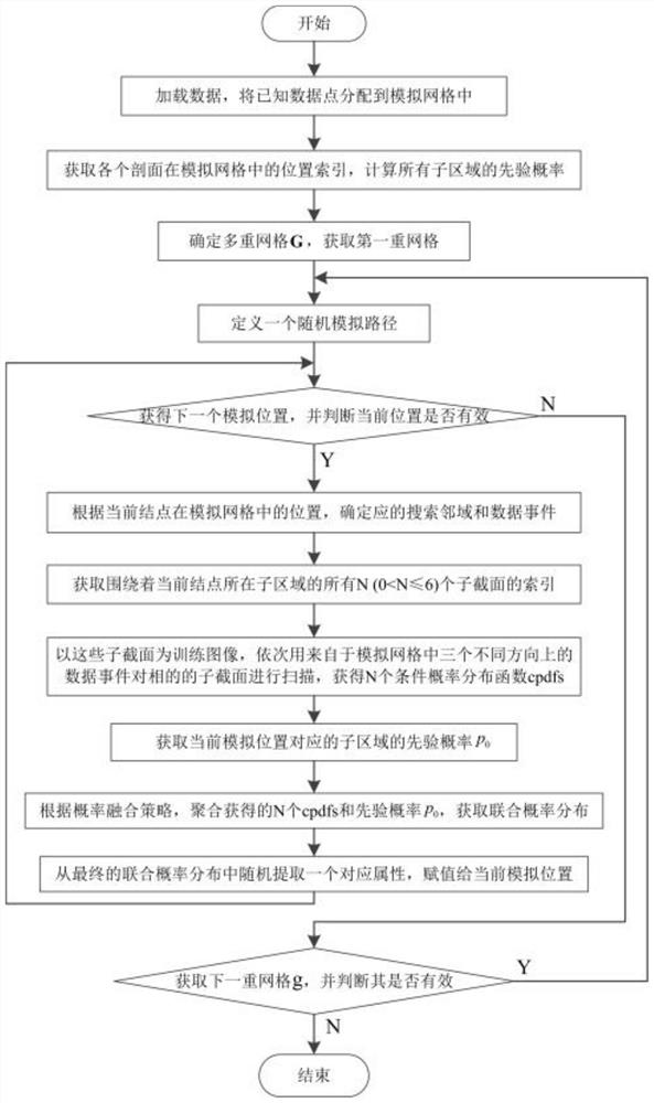
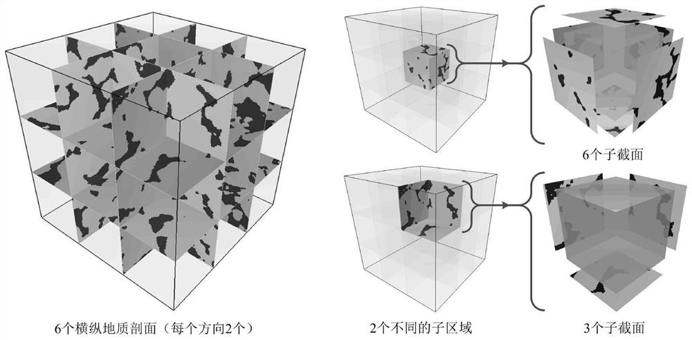
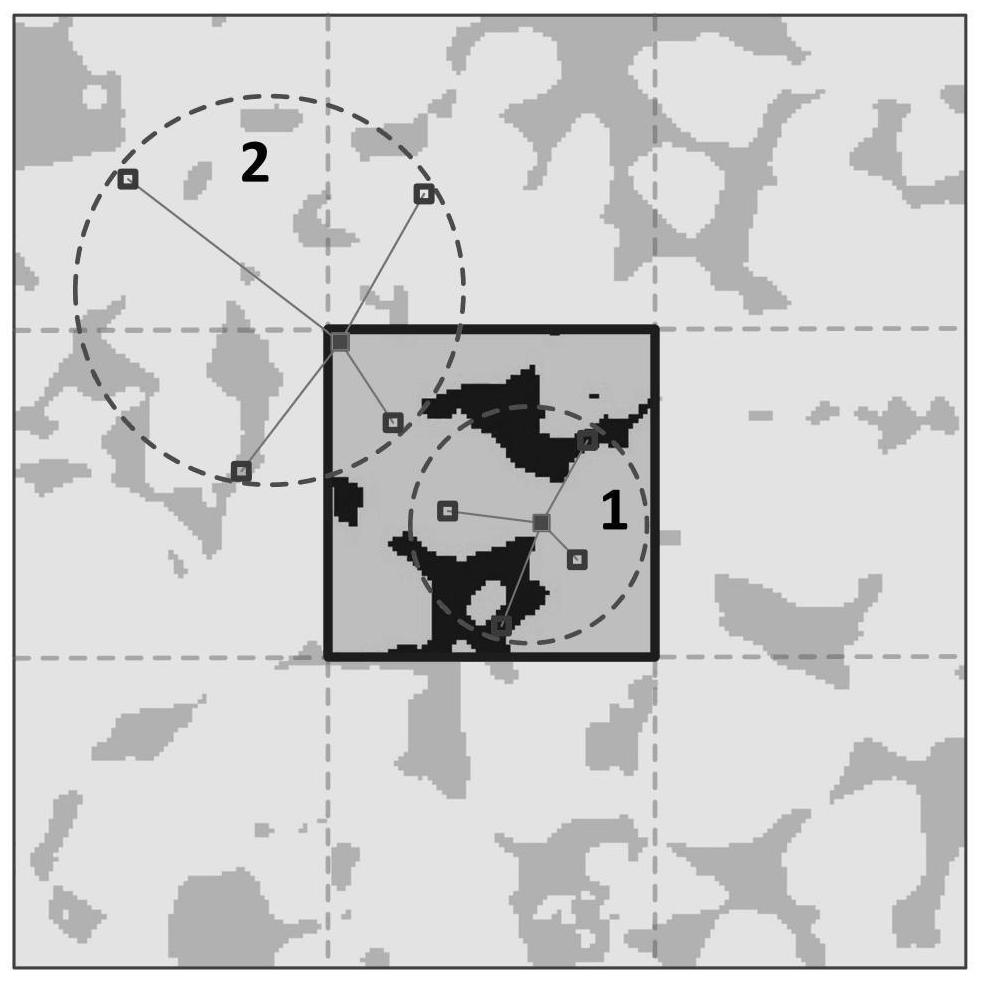
[0061] The embodiment of the present invention provides a multi-point statistical three-dimensional geological model automatic reconstruction method based on a local search strategy, which directly uses two-dimensional horizontal and vertical geological sections to reconstruct a three-dimensional geological structure model, and provides a local Search strategy; this strategy divides the 3D modeling space into several sub-areas according to the spatial interlacing relationship of the known sections, and each sub-area is surrounded by N (1≤N≤6) sub-sections; for each sub-area The unknown attribute position within , its multi-point statistical information is directly obtained from the N subsections surrounding the subregion: first obtain the surrounding N su...


PUM


Abstract

The invention discloses a multi-point statistical three-dimensional geological model automatic reconstruction method based on a local search strategy. The three-dimensional geological model is directly reconstructed by two-dimensional horizontal and vertical geological sections, and the three-dimensional modeling space is reconstructed according to the spatial interlacing relationship of the known sections. Divided into several sub-regions, each sub-region is surrounded by N (1≤N≤6) sub-sections; for the unknown attribute position distributed in each sub-region, first obtain the surrounding N sub-sections according to its position, and then according to the set Customize the data events in the X, Y, and Z directions with the specified neighborhood parameters and known data points, scan the sub-sections in the corresponding directions with the corresponding data events, and obtain N conditional probability density functions; then use a reasonable probability The fusion strategy obtains the joint probability density distribution, and finally obtains the attribute value of the location. The invention can be popularized and applied in various three-dimensional geological information systems, geographic information systems, geological modeling and simulation systems.

Description

technical field [0001] The invention relates to the fields of three-dimensional geological modeling and geological statistical simulation, in particular to a multi-point statistical three-dimensional geological model automatic reconstruction method based on a local search strategy. Background technique [0002] 3D geological modeling and visualization technology is one of the core technologies in the field of geospatial information science, and also the key and basic technology for the construction of 3D geographic and geological information systems. The three-dimensional visual representation of geological structure can provide a more realistic and intuitive description of underground geological phenomena and structures, and has played an important role in the quantitative evaluation of groundwater, oil and solid mineral resources. Spatial heterogeneity and connectivity of reservoirs play an important controlling role in subsurface fluid migration and accumulation, which is...

Claims


Application Information

Patent Timeline
Patent Type & Authority Patents(China)
IPC IPC(8): G06T17/05G06T17/20
CPCG06T17/05G06T17/20
Inventor 陈麒玉刘刚张志庭何珍文田宜平张夏林张继吟余文迪
Owner CHINA UNIV OF GEOSCIENCES (WUHAN)
Why Eureka
Try Eureka