Surveying and mapping geographic information quality management system

A technology for surveying and mapping geography and information quality, which is applied in geographic information databases, transmission systems, electronic digital data processing, etc. Effect

Inactive Publication Date: 2018-08-28
重庆市地理信息中心
View PDF3 Cites 7 Cited by
  • Summary
  • Abstract
  • Description
  • Claims
  • Application Information

AI Technical Summary

Problems solved by technology

[0003] However, these two types of systems do not combine the "acceptance of surveying and mapping product quality inspection business", "implementation of surveying and mapping product quality inspection" and "aided de

Method used


Image

  • Surveying and mapping geographic information quality management system
  • Surveying and mapping geographic information quality management system

Examples


Embodiment Construction

[0022] The specific implementation manner and working principle of the present invention will be further described in detail below in conjunction with the accompanying drawings.

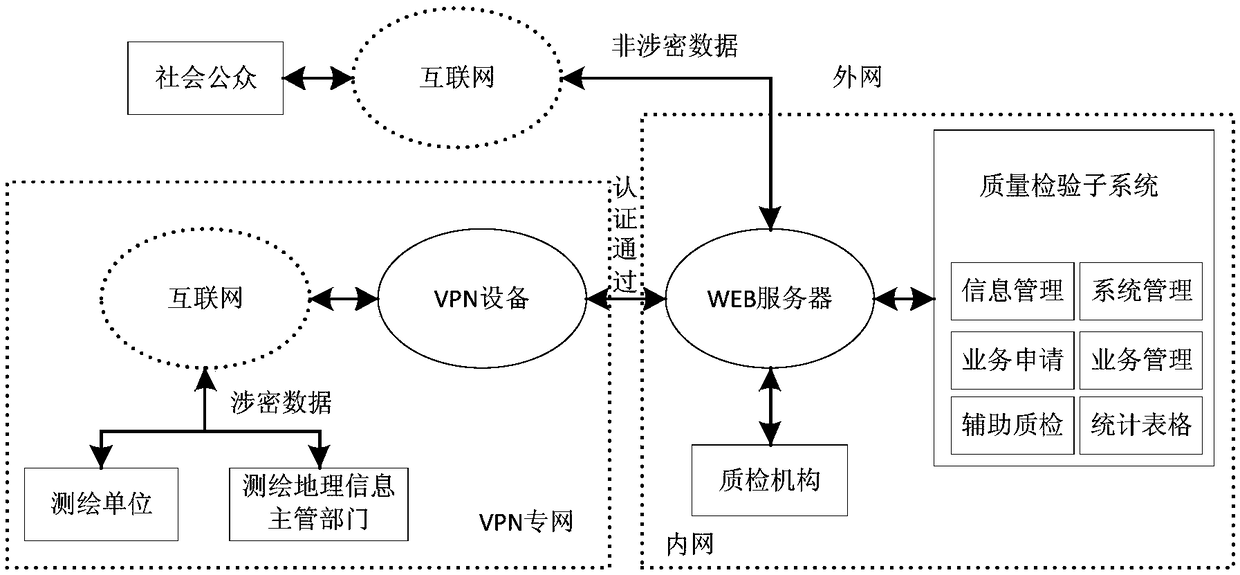
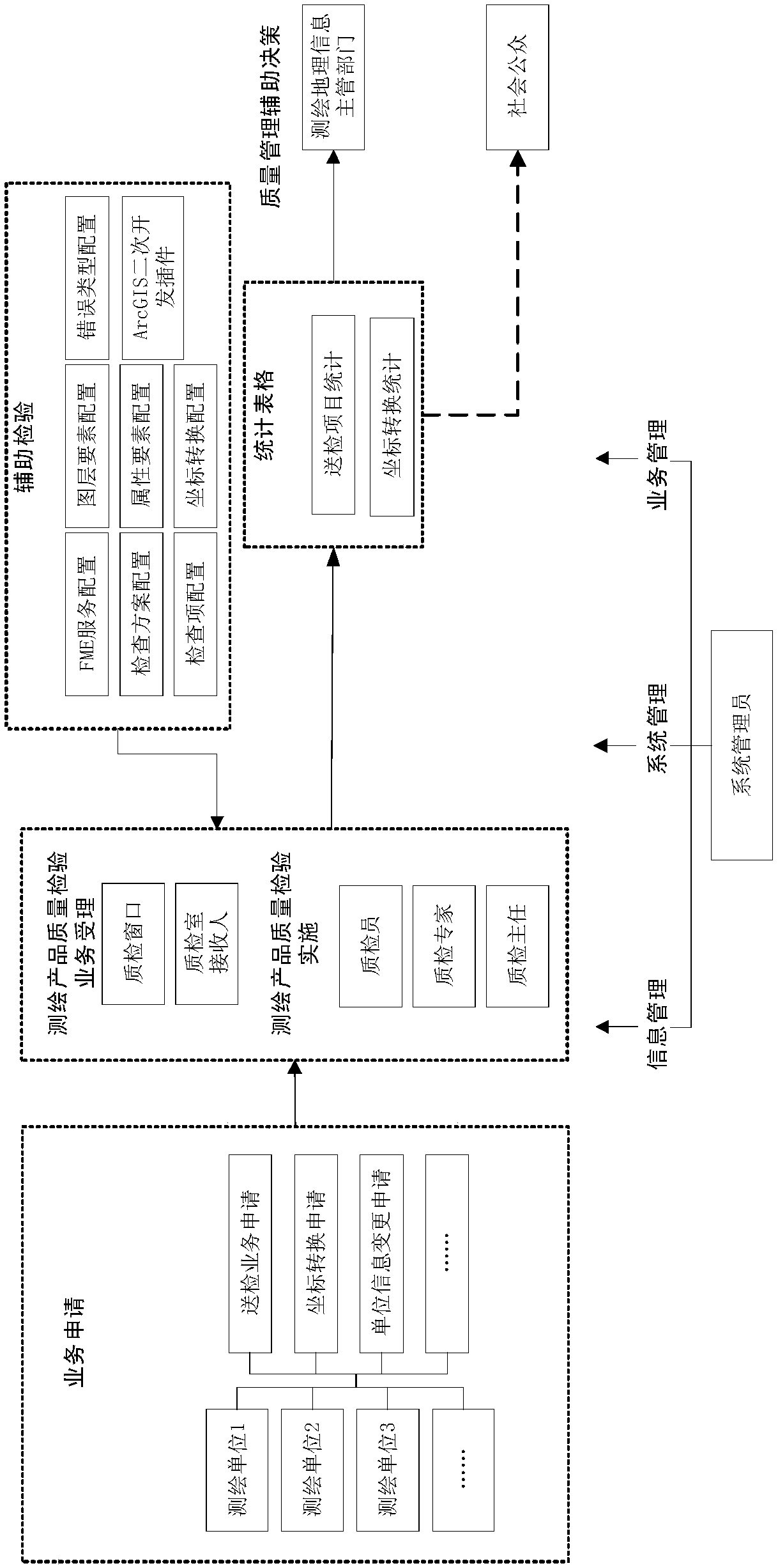
[0023] Such as figure 1 As shown, a surveying and mapping geographic information quality management system, including WEB server, VPN equipment and quality inspection subsystem,

[0024] The WEB server is composed of a computer server with a memory of 64G and a storage capacity of 2T and Internet services, and is used to accept surveying and mapping product quality inspection and CORS measurement data coordinate conversion business, and is used by users of surveying and mapping geographic information authorities, users of surveying and mapping units, and users of quality inspection institutions. Inquiry of statistical information provided by social public users;

[0025] The VPN device communicates with the WEB server to establish a VPN private network environment, and authorizes the surveying and m...


PUM


Abstract

The invention discloses a surveying and mapping geographic information quality management system. The system comprises a WEB server, a VPN device and a quality check subsystem, wherein the WEB serveris used for receiving surveying and mapping product quality check and CORS measurement data coordinate conversion businesses and providing statistical information query for users; the VPN device is incommunication connection with the WEB server and is used for creating a VPN private network environment and authorizing a surveying and mapping geographic information management department and a surveying and mapping unit to use a private network; and the quality check subsystem runs in the WEB server and is used for performing permission configuration on various users and allocating different information resources according to user types. The system has the remarkable effects that three links including ''surveying and mapping product quality check business handling'', ''surveying and mappingproduct quality check implementation'' and ''quality management aided decision making'' are organically integrated; surveying and mapping product quality check services and surveying and mapping quality management aided decision making are taken into account; and more convenient surveying and mapping geographic information quality management services can be provided for various users.

Description

technical field [0001] The invention relates to the technical field of geographic information surveying and mapping quality management, in particular to a surveying and mapping geographic information quality management system. Background technique [0002] The surveying and mapping geographic information quality management system is an information platform for the surveying, mapping, and geographic information authorities to supervise the quality of surveying, mapping, and geographic information products within their jurisdiction. At present, the National Bureau of Surveying, Mapping and Geographic Information and many provinces and cities across the country have established platforms for quality management or supervision of surveying and mapping geographic information. These platforms can be roughly divided into two categories according to their use characteristics: one is the quality supervision and inspection of surveying and mapping products in Sichuan The DLG quality in...

Claims


Application Information

Patent Timeline
IPC IPC(8): G06F17/30G06F17/50G06F21/31G06F21/60G06F21/62H04L29/06H04L29/08
CPCG06F16/2462G06F16/29G06F21/31G06F21/604G06F21/6218G06F30/20G06F2221/2113G06F2221/2141H04L63/0272H04L67/02H04L67/12
Inventor 唐辉张黎吴国梁张泽烈徐永书李静蒲德祥高翔刘邢巍王静张士勇夏定辉杨宁李胜吴寒袁烽迪田强
Owner 重庆市地理信息中心
Why Eureka
Try Eureka