A method, device, terminal and medium for displaying enlarged images of intersections
A technology for enlarging images and display methods of intersections, applied in the field of navigation, can solve the problem of lack of excellent navigation methods, etc., and achieve the effect of saving traffic
- Summary
- Abstract
- Description
- Claims
- Application Information
AI Technical Summary
Problems solved by technology
Method used
Image
Examples
Embodiment 1
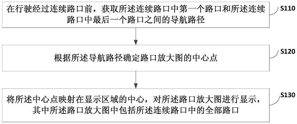
[0038] figure 1 It is a flow chart of a method for displaying an enlarged intersection map provided by Embodiment 1 of the present invention. This embodiment is applicable to the situation of navigating an upcoming intersection, and typically the intersection may be a continuous intersection. The method can be executed by a display device for an enlarged intersection map, and the device can be realized by software and / or hardware. Exemplarily, the device may be a vehicle navigation device, or other terminals (such as a mobile phone) with a navigation function. see figure 1 A method for displaying an enlarged intersection map provided in this embodiment includes:
[0039] S110. Acquire a navigation route between the first intersection in the continuous intersections and the last intersection in the continuous intersections before driving through the consecutive intersections.
[0040] Wherein, the consecutive intersections include at least two intersections, and the distanc...
Embodiment 2
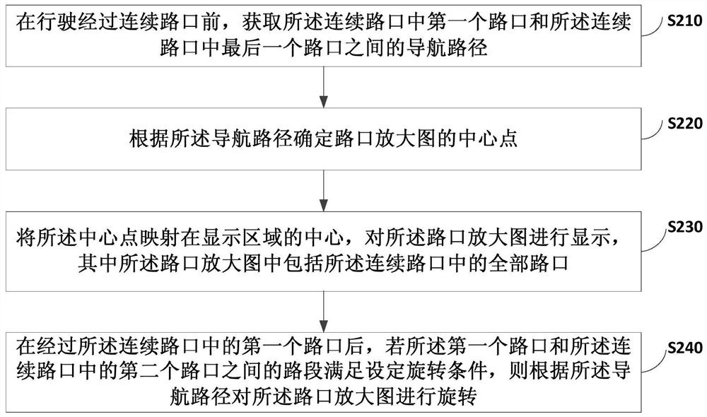
[0057] figure 2 It is a flow chart of a method for displaying an enlarged intersection map provided by Embodiment 2 of the present invention. This embodiment is an optional solution proposed on the basis of the foregoing embodiments. see figure 2 A method for displaying an enlarged intersection map provided in this embodiment includes:
[0058] S210. Acquire a navigation route between the first intersection in the continuous intersections and the last intersection in the continuous intersections before driving through the consecutive intersections.
[0059] S220. Determine the center point of the enlarged intersection map according to the navigation route.
[0060] S230. Map the center point to the center of the display area, and display the enlarged intersection map, wherein the enlarged intersection image includes all intersections in the continuous intersections.
[0061] S240. After passing through the first intersection of the continuous intersections, if the sectio...
Embodiment 3
[0070] Image 6 It is a flowchart of a method for displaying an enlarged intersection map provided by Embodiment 3 of the present invention. This embodiment is an optional solution proposed on the basis of the above embodiments. see Image 6 , the method for displaying the enlarged intersection map provided in this embodiment includes:
[0071] S310. During driving along the navigation route, if it is detected that the distance between the current location and the upcoming fork is smaller than the first distance threshold, then detect whether the fork belongs to a continuous intersection.
[0072] Wherein, the first distance threshold may be determined according to actual needs. A fork is an intersection where a change in direction of travel is required.
[0073] S320. If the distance between any two adjacent intersections among the at least two intersections including the bifurcation intersection in the navigation route is less than a second distance threshold, determine ...
PUM
 Abstract
Description
Claims
Application Information
 - R&D
- Intellectual Property
- Life Sciences
- Materials
- Tech Scout
- Unparalleled Data Quality
- Higher Quality Content
- 60% Fewer Hallucinations
Browse by: Latest US Patents, China's latest patents, Technical Efficacy Thesaurus, Application Domain, Technology Topic, Popular Technical Reports.
© 2025 PatSnap. All rights reserved.Legal|Privacy policy|Modern Slavery Act Transparency Statement|Sitemap|About US| Contact US: help@patsnap.com


