MapGIS-based three-dimensional visualization system for south sea combustible ice geologic models

A geological model and three-dimensional technology, applied in the three-dimensional field of geographic information system, can solve the problem that combustible ice has not been popularized by the public

Inactive Publication Date: 2018-09-21
CHINA UNIV OF GEOSCIENCES (WUHAN)
View PDF3 Cites 3 Cited by
  • Summary
  • Abstract
  • Description
  • Claims
  • Application Information

AI Technical Summary

Problems solved by technology

However, the knowledge of combustible ice has not yet been popularized by the public.

Method used


Image

  • MapGIS-based three-dimensional visualization system for south sea combustible ice geologic models

Examples


Embodiment Construction

[0022] In order to have a clearer understanding of the technical features, purposes and effects of the present invention, the specific implementation manners of the present invention will now be described in detail with reference to the accompanying drawings.

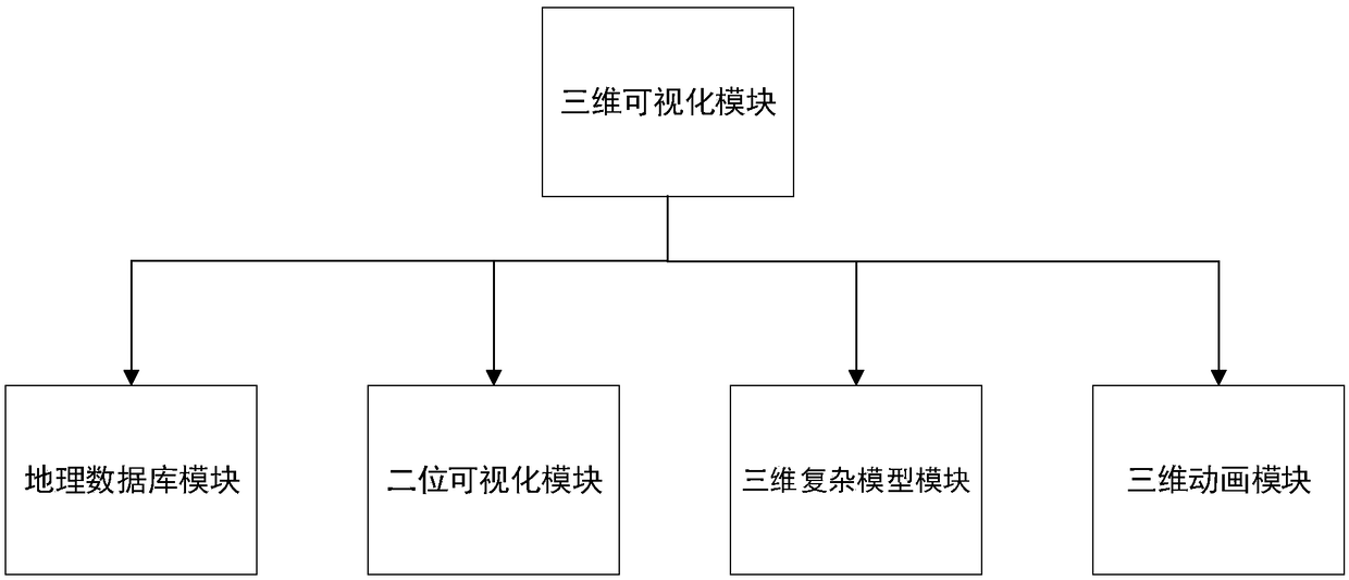
[0023] refer to figure 1 , a MapGIS-based three-dimensional visualization system for the South China Sea combustible ice geological model, including a three-dimensional visualization module, the three-dimensional visualization module includes a geographic database module, a two-dimensional visualization module, a three-dimensional complex model module and a three-dimensional animation process module.

[0024] The geographic database module is based on the geographic database of MapGIS, which can edit each geographic data type, add and delete layers, and add many attribute elements and their values ​​on the layers to realize the access of geographic data. Because MapGIS can integrate multi-source geographic information i...


PUM


Abstract

The invention discloses a MapGIS-based three-dimensional visualization system for south sea combustible ice geologic models. The system comprises a three-dimensional visualization module, wherein thethree-dimensional visualization module comprises a geographic database module, a two-dimensional visualization module, a three-dimensional complicated model module and a three-dimensional animation process module; the geographic database module is used for editing geographic data types, adding and deleting map layers, adding attribute elements and numerical values thereof on the map layers and accessing geographic data; the two-dimensional visualization module is used for carrying out two-dimensional visualization on geographic data in a geographic database; the three-dimensional complicated model module is used for visualizing three-dimensional models, adding self-defined annotations, checking object parameters and modifying attributes thereof; and the three-dimensional animation module is used for expressing the whole process of combustible ice forming in an animation form through a dynamic process of constructing three-dimensional complicated models. According to the system, detailed display of knowledges related to combustible ice can be realized, so that users can efficiently know the molecular models, energy advantages and forming processes of the combustible ice.

Description

technical field [0001] The invention belongs to the three-dimensional field of geographic information systems, and in particular relates to a three-dimensional visualization system of the South China Sea combustible ice geological model based on MapGIS. Background technique [0002] A person's intuitive overall understanding of things can often deepen people's understanding and mastery of things. A correct understanding and mastery of things can stimulate people's interest in and research on things. Unintuitive understanding will only make people have no clear thinking about things, and their thinking will be confused, thus weakening their interest in things. For example: because everyone's occupation is different, people also need to know some things that have nothing to do with their own occupation because of the future development trend, especially when it comes to more complicated things, people are not incapable of mastering one thing, but It is the lack of an intuiti...

Claims


Application Information

Patent Timeline
Patent Type & Authority Applications(China)
IPC IPC(8): G06F17/30G06T17/05G06T13/60
CPCG06T13/60G06T17/05
Inventor 孙斌梁晓涛
Owner CHINA UNIV OF GEOSCIENCES (WUHAN)
Why Eureka
Try Eureka