Road traffic marking detection method and system based on low-altitude aerial image of UAV

A road traffic and aerial image technology, applied in the traffic application field of traffic information technology and computer vision technology, can solve the problems of poor real-time performance and large amount of calculation, and achieve the goal of expanding the road shooting area, improving efficiency and reducing the amount of calculation. Effect

Active Publication Date: 2018-09-28
湖南鲲鹏智汇科技有限公司
View PDF8 Cites 12 Cited by
  • Summary
  • Abstract
  • Description
  • Claims
  • Application Information

AI Technical Summary

Problems solved by technology

This type of method is not suitable for marking detection of unstructured roads, and

Method used


Image

  • Road traffic marking detection method and system based on low-altitude aerial image of UAV
  • Road traffic marking detection method and system based on low-altitude aerial image of UAV
  • Road traffic marking detection method and system based on low-altitude aerial image of UAV

Examples


Embodiment Construction

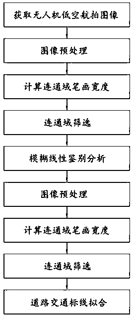
[0050] In order to facilitate the implementation of the present invention, a further description will be given below in conjunction with specific examples.

[0051] Such as figure 1 The shown road traffic marking detection method based on drone low-altitude aerial imagery, the specific steps include:

[0052] S1. Obtaining lane images of low-altitude aerial photography by drones

[0053] There is no shooting angle requirement for the acquired low-altitude aerial photography lane images of drones, but the shooting angle and height change within a certain range within a shooting operation, the shooting angle change does not exceed 20 degrees, and the shooting height does not exceed 15 Meters, the shooting height does not exceed 60 meters. The weather conditions of the shooting are subject to the road traffic markings in the image that human eyes can recognize. The lane image acquired in this step is called the original image in this embodiment.

[0054] S2, preprocess the acquired ori...


PUM


Abstract

The invention provides a road traffic marking detection method and system based on a low-altitude aerial image of an UAV, comprising the steps of acquiring a low-altitude aerial lane image of the UAV;pre-processing the acquired lane image; and calculating the stroke width of the pixel in each connected domain of the pre-processed lane image; screening the connected domains according to the strokewidth of the pixel for sorting the road traffic markings and the roads; and precisely determining the positions of the road traffic markings in the screened connected domains of the road traffic markings by a cubic B spline curve-fitting algorithm based on random sampling consistency. The influences of low-altitude shooting angle, height change, light intensity change, water mark, lane line damage and green belt and shadow on road traffic marking detection are reduced, and the lane lines, arrows, sidewalks, stop lines, etc. are detected. The UAV airborne real-time processing of road traffic marking detection is realized. The invention is applied to the field of traffic information technology and computer vision technology traffic application.

Description

Technical field [0001] The invention relates to the traffic application field of traffic information technology and computer vision technology, in particular to a road traffic marking detection method and system based on low-altitude aerial images of drones. Background technique [0002] Clear road traffic markings can help drivers make driving judgments and safe driving. During road administration inspections, damaged road traffic markings need to be detected and repaired in time. During traffic law enforcement inspections, it is also possible to monitor whether there are vehicles driving illegally by detecting road traffic markings. In the rapidly developing technologies such as intelligent driving and unmanned driving, the method of detecting lane lines is also widely used to assist vehicles in lane keeping. In addition, when making high-precision maps, it is also necessary to accurately extract the location and attributes of road traffic markings. [0003] Lane images taken b...

Claims


Application Information

Patent Timeline
IPC IPC(8): G06K9/00
CPCG06V20/588
Inventor 罗林燕谭鑫黄新景周哲蒋自成
Owner 湖南鲲鹏智汇科技有限公司
Why Eureka
Try Eureka