Three-dimensional reconstruction-based unmanned aerial vehicle image stitching method and system

An image stitching and three-dimensional reconstruction technology, which is applied in the field of remote sensing image stitching, can solve the problems of short stitching time and deformation of stitched images, and achieve the effect of improving stitching speed

Inactive Publication Date: 2018-11-06
INST OF REMOTE SENSING & DIGITAL EARTH CHINESE ACADEMY OF SCI
View PDF2 Cites 54 Cited by
  • Summary
  • Abstract
  • Description
  • Claims
  • Application Information

AI Technical Summary

Problems solved by technology

The stitching process of this method is simple, the stitching process does not require manual intervention, the stitching time is short, and no other geographical control information is required in the stitching, but the disadvantage of this method is that there is image distortion in the final stitched image, especially when the shooting area When the value is larger, the distortion of the spliced ​​image is more obvious

Method used


Image

  • Three-dimensional reconstruction-based unmanned aerial vehicle image stitching method and system
  • Three-dimensional reconstruction-based unmanned aerial vehicle image stitching method and system
  • Three-dimensional reconstruction-based unmanned aerial vehicle image stitching method and system

Examples


Embodiment 1

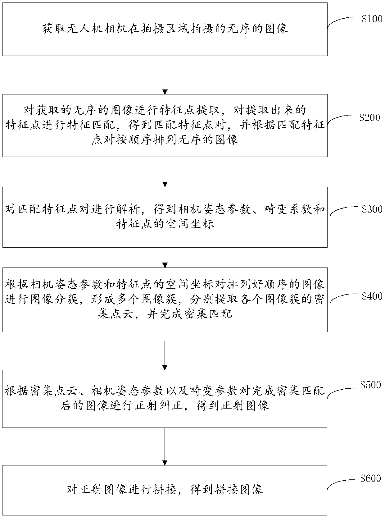
[0064] In a specific embodiment, a method for mosaicing UAV images based on 3D reconstruction is provided, such as figure 1 shown, including:

[0065] Step S100: Obtain unordered images captured by the drone camera in the shooting area.

[0066] Step S200: Extract feature points from the acquired disordered images, perform feature matching on the extracted feature points, obtain matching feature point pairs, and arrange disordered images in order according to the matching feature point pairs.

[0067] Scale-invariant feature transform (SIFT, Scale-invariant feature transform, SIFT) operator is used to extract feature points. Feature points include SIFT feature points themselves and SIFT feature vectors corresponding to SIFT feature points. Due to the large amount of image data acquired, The amount of calculation in the processing process is large, so using a graphics processing unit (GPU, Graphics Processing Unit) for SIFT operator extraction can greatly improve the running s...

Embodiment 2

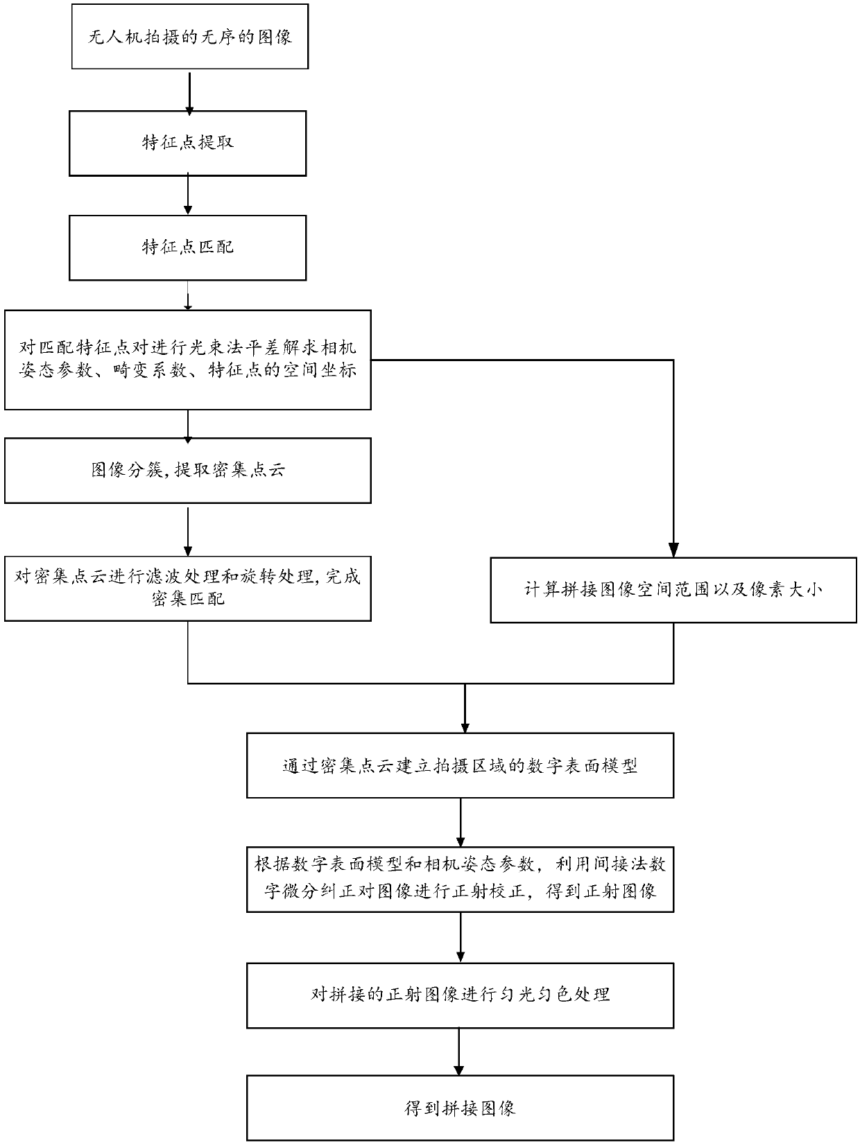
[0162] The present invention also provides a UAV image mosaic system based on three-dimensional reconstruction, including:

[0163] The image acquisition module 10 is used to acquire the unordered images taken by the unmanned aerial vehicle camera in the shooting area;

[0164] Image arranging module 20, is used for carrying out feature point extraction to the unordered image of acquisition, carries out feature matching to described feature point, obtains matching feature point pair, and arranges disordered image in order according to described matching feature point pair;

[0165] Feature point coordinate parsing module 30, is used for analyzing described matching feature point, obtains the space coordinate of camera attitude parameter, distortion parameter and described feature point;

[0166] The dense matching module 40 is used to perform image clustering on the images arranged in order according to the camera pose parameters and the spatial coordinates of the feature poin...


PUM


Abstract

The invention provides a three-dimensional reconstruction-based unmanned aerial vehicle image stitching method. The method comprises the following steps of: obtaining unordered images shot by an unmanned aerial vehicle camera in a shooting area; carrying out feature point extraction on the obtained unordered images, carrying out feature matching on the extracted feature points to obtain matched feature point pairs; and sorting the unordered images according to the matched feature points and a sequence; analyzing the matched feature points so as to obtain camera attitude parameters, distortionparameters and space coordinates of the feature points; carrying out image clustering on the arranged images according to the camera attitude parameters and the space coordinates of the feature pointsso as to form a plurality of image clusters, respectively extracting dense point clouds of the image clusters, and completing dense matching; and carrying out ortho-rectification on the dense matchedimages according to the dense point clouds, the camera attitude parameters and the distortion parameters, and stitching the ortho-rectified images to obtain a stitched image. According to the method,the stitching speed is improved and projection distortion is not caused. The invention furthermore provides an unmanned aerial vehicle image stitching system.

Description

technical field [0001] The present invention relates to the field of remote sensing image mosaic technology, in particular to a method for mosaicing images of drones based on three-dimensional reconstruction, and also to a system for mosaicing images of drones based on three-dimensional reconstruction. Background technique [0002] In modern society, remote sensing technology has become a necessary high-tech means for human beings to obtain information about the geographical environment and its changes. Compared with the costly space remote sensing system, UAV (Unmanned Aerial Vehicles, referred to as UAV), as a remote sensing platform for space photography and earth observation, has a huge advantage in cost. At the same time, the UAV remote sensing (Unmanned Aerial Vehicle Remote Sensing, referred to as UAVRS) system technology has irreplaceable advantages of other remote sensing technologies. It uses fixed-wing UAV, unmanned rotorcraft, and vertical take-off and landing U...

Claims


Application Information

Patent Timeline
Patent Type & Authority Applications(China)
IPC IPC(8): G06T3/40G06T7/10G06K9/46G06K9/62
CPCG06T3/4038G06T7/10G06T2207/10032G06T2207/10012G06V10/462G06V10/759G06F18/22
Inventor 唐娉邹松胡昌苗单小军唐吉文郑柯
Owner INST OF REMOTE SENSING & DIGITAL EARTH CHINESE ACADEMY OF SCI
Why Eureka
Try Eureka