A method of flight plan safety judgment and early warning based on four-dimensional trajectory operation
A safety and flight technology, applied in the field of flight planning safety judgment, can solve the problems of increased workload of controllers and pilots, ineffective use of airspace, and low level of air traffic safety. The effect of flight safety level and balanced utilization rate
- Summary
- Abstract
- Description
- Claims
- Application Information
AI Technical Summary
Problems solved by technology
Method used
Image
Examples
specific Embodiment approach 1
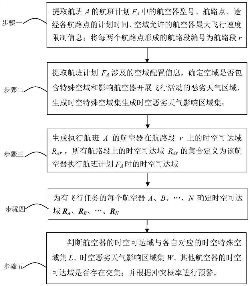
[0054] Specific implementation mode one: combine figure 1 To describe this embodiment,
[0055] A method for judging and early warning of flight plan safety based on four-dimensional track operation, comprising the following steps:
[0056] Step 1: 2 hours before the flight, retrieve the flight plan F of flight A A aircraft type, waypoints, planned time passing through each waypoint, and the maximum flight speed limit information of the aircraft allowed in the airspace; the route segment formed by every two way points is numbered as route segment r, r=1, 2, 3, ...,k;
[0057] Step 2: Extract flight plan F A Involved airspace configuration information (including airspace name, attribute, boundary, opening time), determine whether the airspace contains special airspace (including prohibited airspace, restricted airspace, dangerous airspace); generate time-space Special airspace set L;
[0058] Extract flight plan F A Involved airspace meteorological information to determin...
specific Embodiment approach 2
[0065] In the second step of the present embodiment, the process of generating the space-time special airspace set L is as follows:
[0066] First, take the plane where the route segment r is located as the x-y plane, and use time as the z-axis to establish a three-dimensional coordinate system, representing the space-time space (equivalent to all the space of the route segment during cruising);
[0067] Secondly, select appropriate discretization parameters to discretize the space-time space into several discretization units; determine the attributes of each discretization unit according to the location, boundary, and opening time information of the special airspace: mark the discretization unit corresponding to the ordinary airspace as 0, the discretization unit corresponding to the special airspace is marked as 1, and the spatiotemporal special airspace set L is generated.
[0068] Other steps and parameters are the same as those in the first embodiment.
specific Embodiment approach 3
[0070] In Step 2 of this embodiment, the process of generating the spatiotemporal severe weather affected area set W is as follows:
[0071] Consider the moving center of severe weather as its moving center of mass, and generate the space-time path of severe weather according to the predicted movement trajectory; and use the expected spread range as the radius to determine the influence range of severe weather in time and space; discrete in the space-time and space On the basis of normalization, the discretization unit corresponding to the ordinary airspace is marked as 0, and the discretization unit corresponding to the spatio-temporal severe weather affected area is marked as 1, so as to generate the spatio-temporal severe weather affected area set L.
[0072] Other steps and parameters are the same as those in Embodiment 1 or 2.
PUM
 Abstract
Description
Claims
Application Information
 - R&D
- Intellectual Property
- Life Sciences
- Materials
- Tech Scout
- Unparalleled Data Quality
- Higher Quality Content
- 60% Fewer Hallucinations
Browse by: Latest US Patents, China's latest patents, Technical Efficacy Thesaurus, Application Domain, Technology Topic, Popular Technical Reports.
© 2025 PatSnap. All rights reserved.Legal|Privacy policy|Modern Slavery Act Transparency Statement|Sitemap|About US| Contact US: help@patsnap.com


