Air Navigation Aid Method and System Making it Possible to Maintain Vertical Margins

a navigation aid and vertical margin technology, applied in vehicle position/course/altitude control, process and machine control, instruments, etc., can solve the problems of not allowing the difference relative to this threshold to be calculated or represented, and the device cannot take into account the instantaneous vertical climb capability of the aircraft, so as to improve the flight safety

Active Publication Date: 2010-01-07
THALES SA
View PDF5 Cites 28 Cited by
  • Summary
  • Abstract
  • Description
  • Claims
  • Application Information

AI Technical Summary

Benefits of technology

[0009]The objective of the invention is to improve flight safety in situations requiring small vertical separations to be maintained in relation to the relief or to artificial obstacles by presenting to the crew all the synthetic digital information generated and by proposing these values to an automatic piloting system to automate their servo-control if necessary.
[0014]selection of the flight setpoints making it possible to maintain the aircraft as close as possible to the obstruction profile while maintaining between the aircraft and the obstruction profile at least the vertical safety margin,
[0016]The invention is advantageous in that it makes it possible to provide the crew with a navigation aid that systematically offers it a presentation of the remaining margins, altitude and vertical speed for example. The crew has an idea of the piloting margins with respect to potential threats. The presentation of the information has the advantage of being synthetic, simply displaying the remaining difference before approaching a risky area. This information enables the crew to avoid leading the aircraft into risky situations or situations generating alerts in the sense of a TAWS for example, and reduces the surprise effect when an alert appears.
[0017]The method also has the advantage of selecting and presenting the flight setpoints of the trajectory making it possible to direct the aircraft as close as possible to the relief and the obstacles while maintaining an adequate safety margin. The vertical safety trajectories can include a point of contact with the obstruction profile increased by the vertical safety margin. The vertical safety trajectories are calculated all along the flight, include their starting points at the same position, that is, from the instantaneous position of the aircraft, and are climb, descent and levelling-off trajectories. The safety trajectory setpoints are instantaneous flight setpoints making it possible to rejoin the safety trajectories at the instantaneous moment. These safety trajectories are predefined in the system. Their function is to calculate the flight setpoints at the instantaneous moment enabling the pilot to approach the obstruction profile as closely as possible while keeping a safety margin. In addition, the display of these flight setpoints in relation to the current flight parameters enables the display device to represent the vertical flight margin on the navigation indicators. Said flight margin represents the difference between the current flight setpoints and the setpoints that make it possible to approach the obstruction profile while remaining in a safe situation. In the rescue intervention case, the crew thus has a piloting indication to bring the aircraft and maintain it as close as possible to the observation or intervention area and to carry out the intervention in the best conditions.

Problems solved by technology

The functions handled by a terrain anti-collision device show limitations.
Moreover, the safety and operational objectives of such equipment do not destine them to fulfil navigation aid functions.
It does not allow the difference relative to this threshold to be calculated or represented.
However, these devices have the drawback of not taking into account the instantaneous vertical climb capabilities of the aircraft, but use default climb rates, a climb angle of 6° for example.
Consequently, the proposed avoidance manoeuvre is not guaranteed according to the actual weight or the local temperature.
Such an approach is incompatible with the integrity objectives of navigation systems.
The FMS cannot be used as a navigation aid system in the face of obstacles because, for the creation of a flight plan, the system does not check the intersection of the proposed trajectory with the relief and does not have a digital terrain model available with which to perform the calculations to maintain separation from the predicted trajectory with the relief.

Method used


Image

  • Air Navigation Aid Method and System Making it Possible to Maintain Vertical Margins
  • Air Navigation Aid Method and System Making it Possible to Maintain Vertical Margins
  • Air Navigation Aid Method and System Making it Possible to Maintain Vertical Margins

Examples


Embodiment Construction

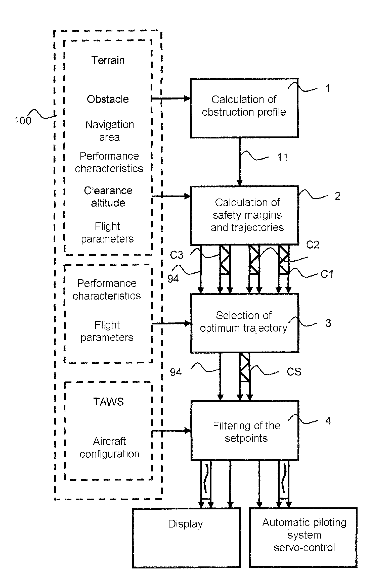
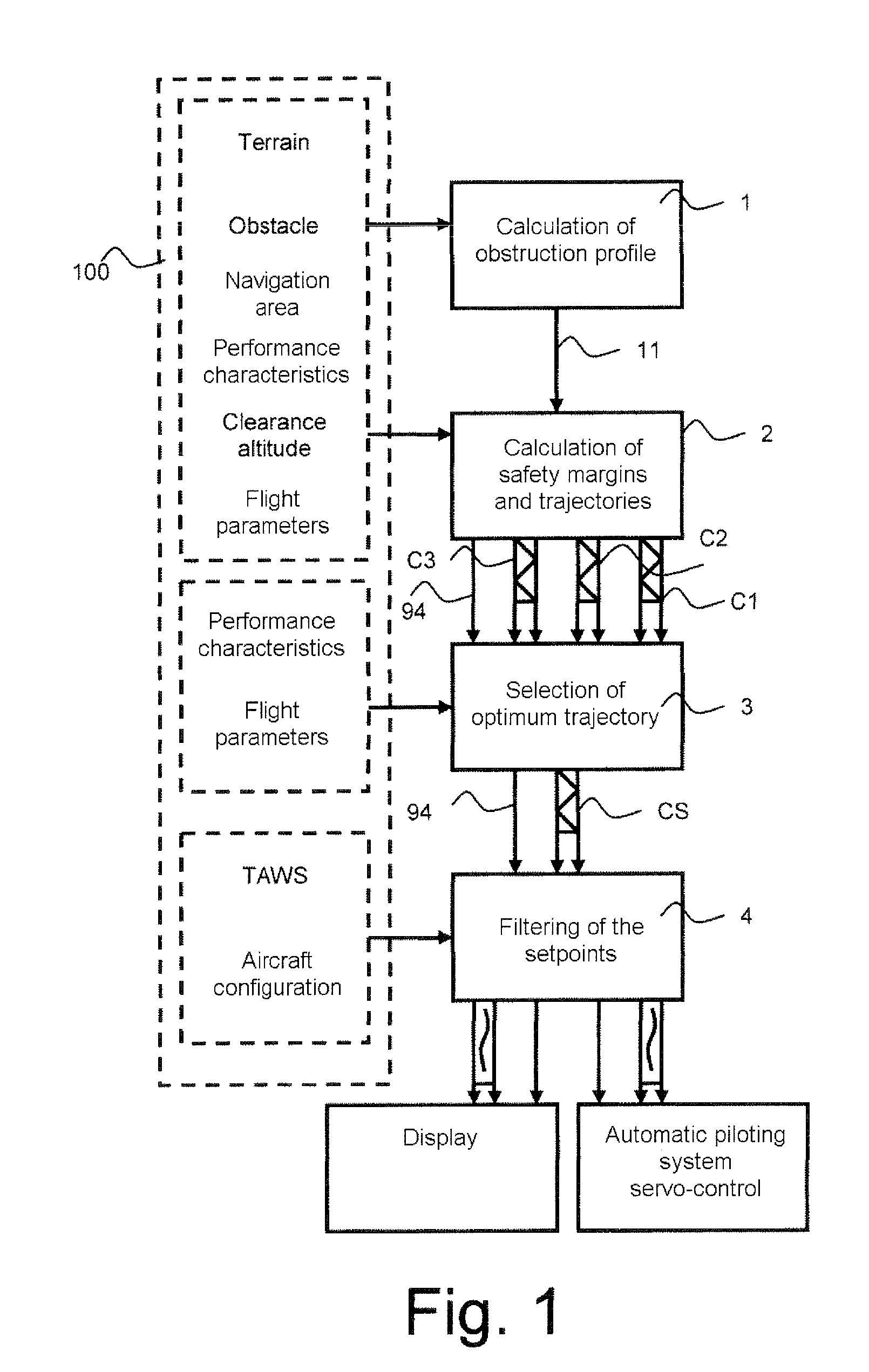
[0033]The aim of the invention is to enhance the flight safety in situations requiring small vertical separations to be maintained with respect to the relief or artificial obstacles. To achieve this objective, the method implements a succession of steps represented by FIG. 1. A first step for calculating a vertical obstruction profile 92, a second step for calculating a vertical safety margin 94, safety trajectories 801, 802, 803 and associated setpoints C1, C2 and C3, the essential characteristic of which is to include a single point of contact with the vertical obstruction profile 92 increased by the vertical safety margin 94, a third step for selecting the safety trajectory CS making it possible to keep an optimum safety margin with respect to the obstruction profile, a fourth step for filtering the setpoints in order for the piloting indication that has to be displayed not to show high variations over a short duration, and finally, a fifth step for displaying the flight setpoint...


PUM


Abstract

The invention relates to a calculation method for an aircraft navigation aid system making it possible to maintain a vertical safety margin with an obstruction profile, the aircraft comprising a navigation system, an automatic piloting system, a database system and a display device, characterized in that the method comprises the following steps: calculation of an obstruction altitude profile, calculation of a vertical safety margin with respect to the obstruction profile, of a plurality of vertical safety trajectories and of the respective flight setpoints for the aircraft to execute the trajectories, selection of the flight setpoints making it possible to maintain the aircraft as close as possible to the obstruction profile while maintaining between the aircraft and the obstruction profile at least the vertical safety margin, filtering of the flight set point values so that the variation of the values of the setpoints does not exceed a variation difference in a duration predefined in the system.

Description

PRIORITY CLAIM[0001]This application claims priority to French Patent Application Number 08 03462, entitled Air Navigation Aid Method and System Making it Possible to Maintain Vertical Margins, filed on Jun. 20, 2008.FIELD OF THE INVENTION[0002]The invention relates to the field of air navigation aids for the prevention of accidents in which the aircraft, still maneuverable, comes into collision with an obstacle. The term “obstacle” hereinafter designates any non-natural obstruction present in the environment of the aircraft, notably human constructions such as buildings or bridges. Moreover, the term “relief” or “terrain” designates the obstructions relating to the natural environment such as mountainous areas and, more generally, the ground.[0003]Because of the type of missions carried out, landing and taking off in areas that are difficult to access, sometimes unprepared, or flying at low altitude, the helicopter, for example, is a craft that is very greatly exposed to the risk o...

Claims


Application Information

Patent Timeline
Patent Type & Authority Applications(United States)
IPC IPC(8): G05D1/06G05D1/00G05D3/00
CPCG05D1/0646
Inventor FLOTTE, LAURENTMARTY, NICOLASSALLIER, AURELIE
Owner THALES SA
Why Eureka
Try Eureka