Method, device and medium for building facade mapping on large scale topographic map of unmanned aerial vehicle

A facade and scale technology, applied in the field of architectural surveying and mapping, can solve problems such as insufficient accuracy of housing surveying and mapping, large selection deviation, and inability to perform surveying and mapping, and achieve the effect of improving the accuracy and efficiency of surveying and mapping

Inactive Publication Date: 2018-12-21
GUANGZHOU URBAN PLANNING & DESIGN SURVEY RES INST
View PDF5 Cites 6 Cited by
  • Summary
  • Abstract
  • Description
  • Claims
  • Application Information

AI Technical Summary

Problems solved by technology

However, when manually drawing the edge of a house directly on a stereo image, a large selection error is likely to occur due to the sharp corners of the linear target in the view; Feature locations such as corner points cannot be directly displayed on the image, making it impossible to perform surveying and mapping
The above-mentioned problems lead to insufficient precision and low efficiency of house surveying and mapping, and to a large extent limit the promotion and application of large-scale topographic maps measured by drones

Method used


Image

  • Method, device and medium for building facade mapping on large scale topographic map of unmanned aerial vehicle
  • Method, device and medium for building facade mapping on large scale topographic map of unmanned aerial vehicle
  • Method, device and medium for building facade mapping on large scale topographic map of unmanned aerial vehicle

Examples


Embodiment Construction

[0041] The technical solutions in the embodiments of the present invention will be clearly and completely described below in conjunction with the accompanying drawings in the embodiments of the present invention. Obviously, the described embodiments are only a part of the embodiments of the present invention, rather than all the embodiments. Based on the embodiments of the present invention, all other embodiments obtained by those of ordinary skill in the art without creative work shall fall within the protection scope of the present invention.

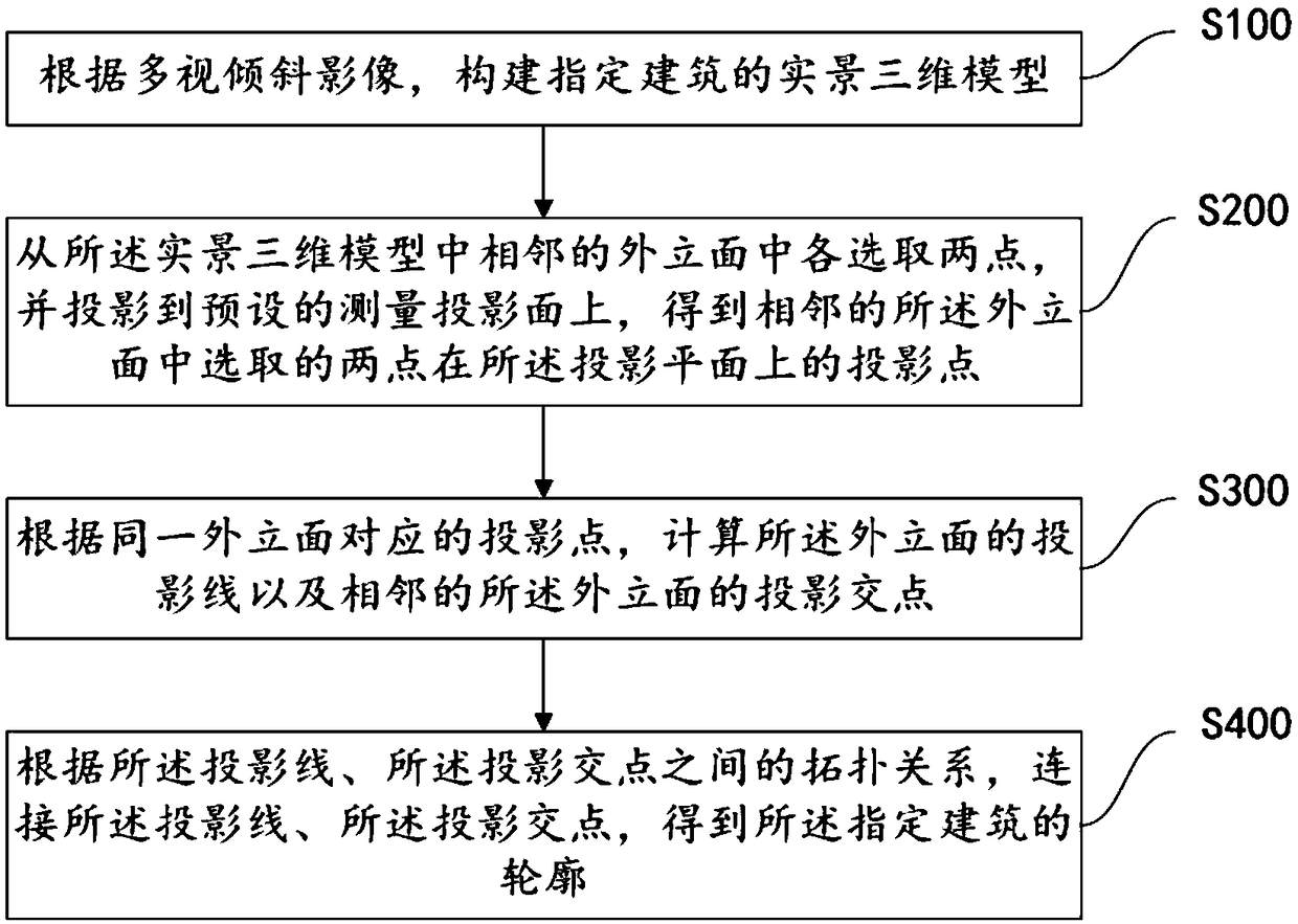
[0042] See figure 1 , Which is a flow chart of a method for surveying and mapping the facade of a house on a large-scale topographic map of a drone provided by an embodiment of the present invention. The method for surveying and mapping the facade of a house on a large-scale topographic map of the drone includes:

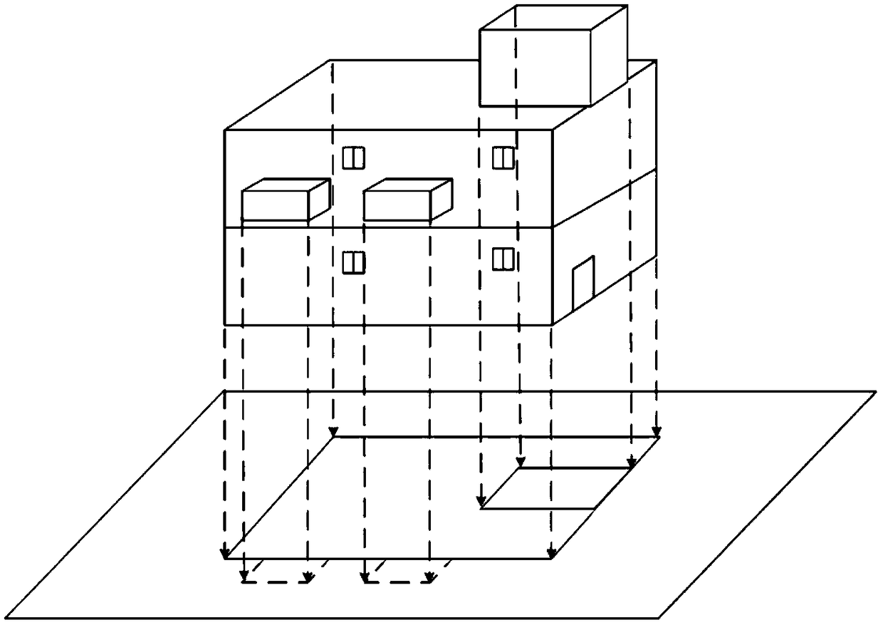
[0043] S100: Construct a real-world 3D model of the designated building based on the multi-view oblique image;
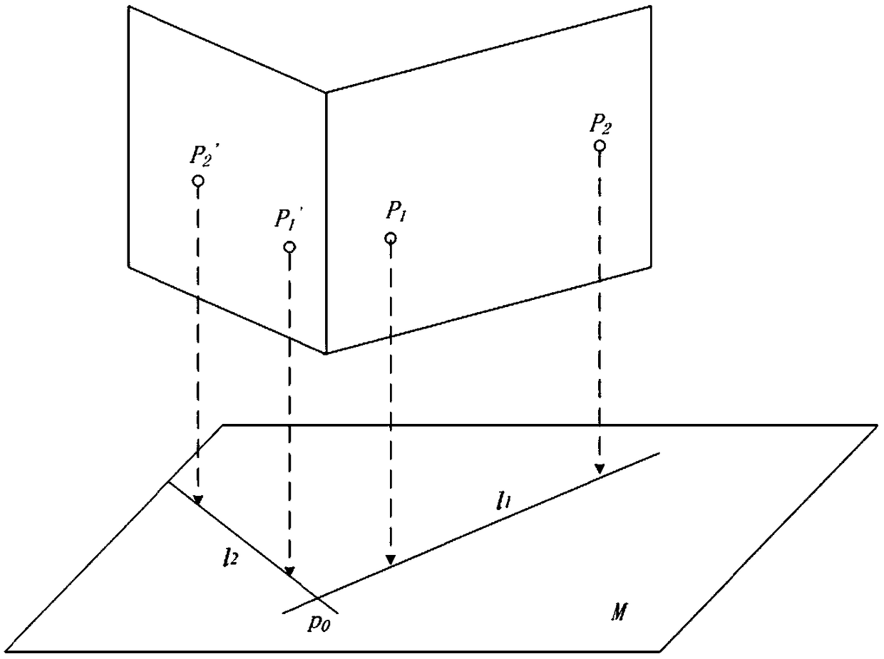
[0044] S200: Se...


PUM


Abstract

The invention discloses a method, a device and a medium for building facade mapping on a large scale topographic map of an unmanned aerial vehicle. The method comprises the following steps: constructing a real three-dimensional model of a designated building based on a multi-view tilt image; selecting two points from adjacent facades in the real three-dimensional model, and projecting the two points onto a preset measuring projection surface to obtain the projection points of the two points selected from the adjacent facades on a projection plane; calculating the projection lines of the facades and the projection intersection points of the adjacent facades according to the projection points corresponding to the same fa ade; and connecting the projection lines and the projection intersection points according to the topological relationship between the projection lines and the projection intersection points to obtain the outline of the designated building. Through adoption of the method,the outlines of buildings can be accurately extracted according to multi-view tilt images, and the surveying and mapping accuracy and efficiency of buildings are improved.

Description

Technical field [0001] The invention relates to the technical field of architectural surveying and mapping, in particular to a method, device and medium for surveying and mapping the facade of a large-scale topographic map of a drone. Background technique [0002] Topographic map is an important universal map, which is the projection of the location and shape of features and topography on a specific horizontal plane. Specifically, it is to project the features and landforms on the ground onto the projection surface along the vertical line, and draw them according to a certain scale. As an important feature, a house is a key element in various topographic maps. The convenience and accuracy of its surveying and mapping are very important to topographic maps. [0003] In recent years, the use of unmanned aerial vehicles to conduct large-scale topographic map surveying with a scale of 1:2000 or even 1:500 has become a hot research topic in the global surveying field. Compared with tr...

Claims


Application Information

Patent Timeline
Patent Type & Authority Applications(China)
IPC IPC(8): G01C11/00
CPCG01C11/00
Inventor 杨光张荣林鸿
Owner GUANGZHOU URBAN PLANNING & DESIGN SURVEY RES INST
Why Eureka
Try Eureka