Joint topographic mapping method based on space-borne SAR image and optical image

A technology of optical images and topographic maps, applied in the field of surveying and mapping, to achieve the effects of improving the accuracy of surveying and mapping, significant social benefits, and huge economic benefits

Active Publication Date: 2018-12-28
国家测绘地理信息局第三航测遥感院
View PDF5 Cites 9 Cited by
  • Summary
  • Abstract
  • Description
  • Claims
  • Application Information

AI Technical Summary

Problems solved by technology

[0004] In recent years, many scholars at home and abroad have carried out research on spaceborne SAR technology. The commonly used data include spaceborne SAR data of COSMO-SKYMED an

Method used


Image

  • Joint topographic mapping method based on space-borne SAR image and optical image
  • Joint topographic mapping method based on space-borne SAR image and optical image
  • Joint topographic mapping method based on space-borne SAR image and optical image

Examples


Embodiment 1

[0083] like figure 1 As shown, a topographic map joint mapping method based on spaceborne SAR image and optical image includes:

[0084] S1, build a SAR positioning model to achieve high-precision positioning of SAR images;

[0085] S2, building a spaceborne SAR stereo model, and collecting topographic map elements based on the stereo model;

[0086] S3, establishing a registration model between the SAR image and the relatively low-resolution optical image, and realizing the pixel-level matching between the optical image and the SAR image after positioning in step S1;

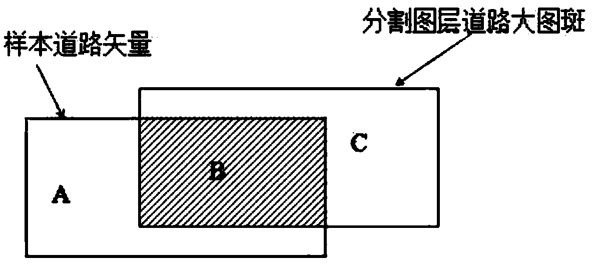
[0087] S4. Based on the registered low-resolution optical image and SAR image, the automatic extraction of ground objects is carried out, and the extracted element vector is fused with the SAR stereo model-based acquisition element vector, and integrated into a digital line drawing result.

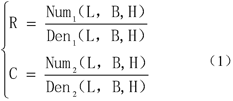
[0088] (1) Solving RPC parameters of foreign spaceborne SAR images

[0089] There are two ways to solve the RPC model ...


PUM


Abstract

The invention discloses a joint topographic mapping method based on a space-borne SAR image and an optical image. The method comprises the following steps: constructing a SAR positioning model to realize high-precision positioning of the SAR image; constructing a space-borne SAR stereo model, and acquiring topographic map elements based on the stereo model; establishing a registration model of theSAR image and the optical image with relatively low resolution to realize matching of the optical image with the pixel level of the SAR image positioned in the step S1; and jointly performing automatic extraction of a ground object target based on the low-resolution optical image and the SAR image after registration, and fusing an extracted element vector with the acquired element vector of the SAR stereo model to integrate a digital line drawing result. The method can be applied to domestic high-resolution No.3 SAR images and foreign SAR images, reduce the cost of production using airborne SAR image mapping, promotes domestic SAR satellite application, improves mapping accuracy, and has important theoretical significance and application popularization value.

Description

technical field [0001] The present invention relates to the technical field of surveying and mapping, and more specifically, relates to a combined topographic map surveying method based on spaceborne SAR images and optical images. Background technique [0002] The "National Basic Surveying and Mapping Mid- and Long-term Planning Outline (2015-2030)" points out that it is necessary to "focus on promoting laser and radar data acquisition" and "expand the coverage of high-precision basic geographic information". Due to the long-term limitation of climate conditions and the level of surveying and mapping technology and equipment, it is very difficult to obtain optical images in our province, which seriously restricts the development of basic surveying and mapping work in our province. Sichuan provincial 1:10,000 topographic map still has 35% of the area not covered, and it is one of the few provinces (districts) in the country that does not cover the whole area. Therefore, "Sich...

Claims


Application Information

Patent Timeline
IPC IPC(8): G01S13/90
CPCG01S13/9005G01S13/904G01S13/9094G01S13/9041G01S13/9027
Inventor 张艳梅蒙印郭文王萍蒋红兵张荞
Owner 国家测绘地理信息局第三航测遥感院
Why Eureka
Try Eureka