A system and method for estimating urban vegetation coverage based on low-altitude remote sensing measurement technology

A technology of vegetation coverage and measurement technology, which is applied in the system field of estimating urban vegetation coverage based on low-altitude remote sensing measurement technology, can solve problems such as difficulty in ensuring measurement accuracy and reliability, complicated operation, and long operation time, and achieve improvement Estimated accuracy and estimated efficiency, and the effect of simplifying the operation process

Active Publication Date: 2021-07-30
颜俊君
View PDF3 Cites 0 Cited by
  • Summary
  • Abstract
  • Description
  • Claims
  • Application Information

AI Technical Summary

Problems solved by technology

The visual method mainly selects sample squares on the ground and estimates based on human experience. This method is difficult to guarantee the accuracy and reliability of the measurement.
The sampling method performs statistical measurement through sampling auxiliary tools in the sample square, but the disadvantage is that the operation is too complicated and takes a long time
Instrumental measurement methods mainly include spatial quantitative measurement method, mobile light meter method and digital camera photogrammetry method. The disadvantage is that it requires people to take pictures on the spot and takes a long time to operate.
In addition, it also includes the traditional aerial remote sensing measurement method. The traditional satellite and aircraft-based data acquisition methods have been widely used, but they are greatly affected by the weather and it is difficult to capture high-resolution images that meet the requirements.

Method used


Image

  • A system and method for estimating urban vegetation coverage based on low-altitude remote sensing measurement technology
  • A system and method for estimating urban vegetation coverage based on low-altitude remote sensing measurement technology

Examples


Embodiment Construction

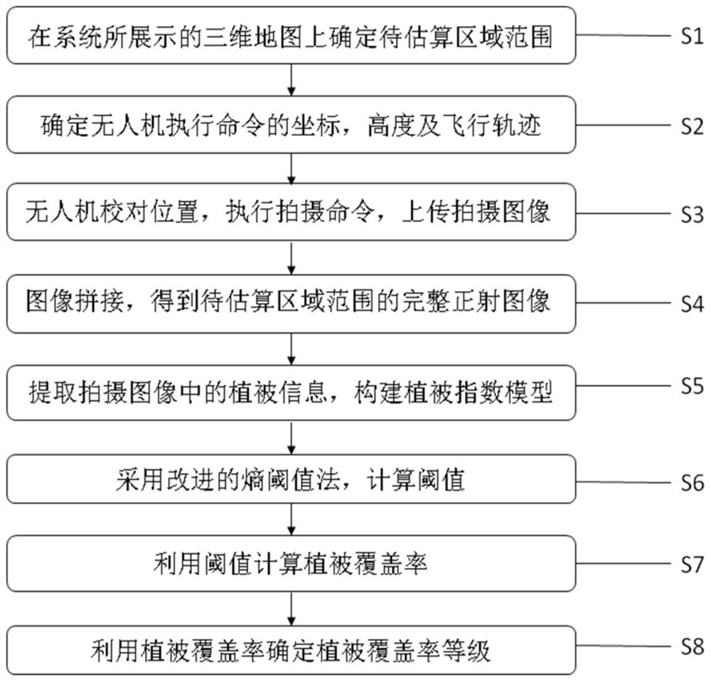
[0036] The present invention will be further described below in conjunction with accompanying drawing:

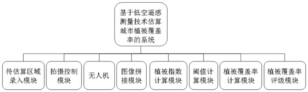
[0037] refer to figure 1 As shown, the embodiment of the present invention provides a system for estimating urban vegetation coverage based on low-altitude remote sensing measurement technology, including:

[0038] The area to be estimated input module is used to determine the area to be estimated on the three-dimensional map displayed by the system. The system calculates the coordinates at the boundary of the area to be estimated according to the entered area to be estimated. The coordinates are global longitude and latitude coordinates. The system determines the coordinates and image features of important buildings within the area to be estimated;

[0039] The shooting control module is used to determine all the coordinate positions where one or more drones need to execute the shooting command, the shooting height and flight trajectory of the drone according to the range...


PUM


Abstract

This application provides a system and method for estimating urban vegetation coverage based on low-altitude remote sensing measurement technology, including: S1. Determine the range of the area to be estimated on the three-dimensional map displayed by the system; S2. Determine the coordinates and height of the UAV to execute the command and flight trajectory; S3, the UAV checks the position, executes the shooting command, and uploads the shooting image; S4, image stitching, obtains a complete ortho image of the area to be estimated; S5, extracts the vegetation information in the shooting image, and builds a vegetation index model ; S6, using the improved entropy threshold method to calculate the threshold; S7, using the threshold to calculate the vegetation coverage; S8 using the vegetation coverage to determine the vegetation coverage level. By improving the estimation process, the application effectively improves the estimation accuracy and estimation efficiency of urban vegetation coverage while simplifying the operation process.

Description

technical field [0001] The invention relates to the field of urban vegetation coverage measurement and estimation, in particular to a system and method for estimating urban vegetation coverage based on low-altitude remote sensing measurement technology. Background technique [0002] Cities are the most concentrated areas of human activities, and exploring the unique properties of urban vegetation has important practical significance for urban planning and urban environmental protection. Urban vegetation is the living plants that cover cities. It includes the sum of all plants such as forests, shrubs, hedges, flower beds, grasslands, trees, crops, etc. owned by parks, campuses, temples, squares, stadiums, hospitals, streets, farmland, and vacant land in the city. [0003] Urban vegetation coverage is usually used to indicate urban greening planning goals or achieved greening achievement indicators. Since the 20th century, cities have developed faster and faster, and the pop...

Claims


Application Information

Patent Timeline
Patent Type & Authority Patents(China)
IPC IPC(8): G06K9/00G06K9/20G06K9/34
CPCG06V20/188G06V10/143G06V10/267
Inventor 颜俊君李诣韩建乐周亚光卫华鹏万小强王小玉朱双燕
Owner 颜俊君
Why Eureka
Try Eureka