Terrain-based unmanned aerial vehicle oblique photography method and system

A technology of oblique photography and unmanned aerial vehicles, which is applied in photogrammetry/video surveying, aircraft parts, measuring devices, etc. high precision effect

Active Publication Date: 2019-01-18
武汉大势智慧科技有限公司
View PDF12 Cites 23 Cited by
  • Summary
  • Abstract
  • Description
  • Claims
  • Application Information

AI Technical Summary

Problems solved by technology

Therefore, this way of working will inevitably lead to a certain amount of redundancy in the amount of photos

Method used


Image

  • Terrain-based unmanned aerial vehicle oblique photography method and system
  • Terrain-based unmanned aerial vehicle oblique photography method and system

Examples


Embodiment

[0028] 1. UAV oblique photography method taking into account the terrain

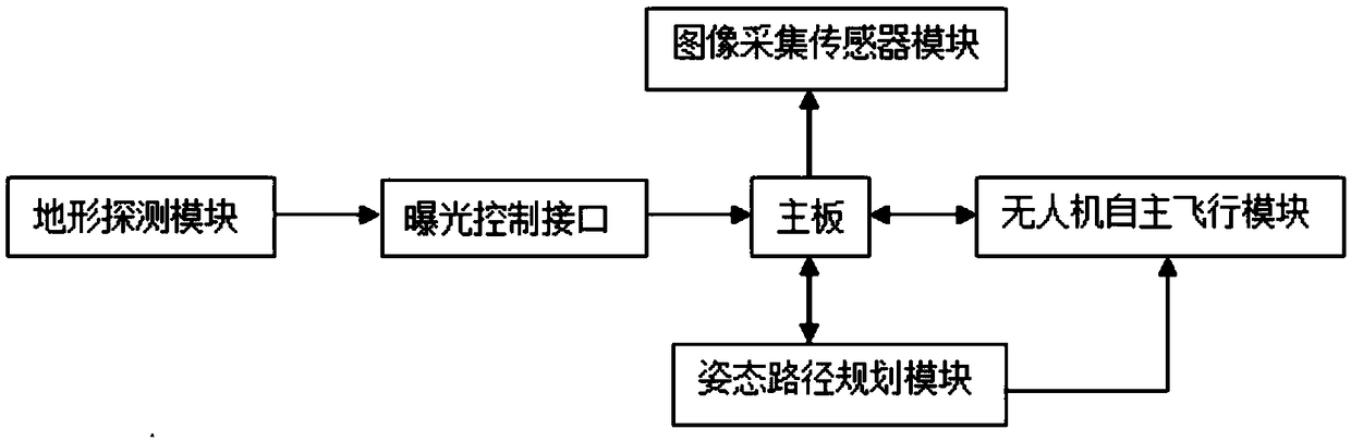
[0029] The data acquisition of the PTZ system requires a certain degree of heading overlap and side overlap between images, which is conducive to 3D reconstruction and image stitching. In the traditional way of taking pictures with pan / tilts, the photo interval, overlapping degree and speed are all constant, which inevitably leads to a certain amount of redundancy in the number of photos. In this embodiment, a method for oblique photography of a UAV that takes terrain into account, the method obtains terrain information and flight height information in real time during the flight process, and according to the real-time terrain information, flight height information, heading overlap rate, lens focal length and Photo interval information, dynamically calculate the current optimal flight speed and exposure interval, and control the UAV to perform aerial photography operations according to this optimal flig...


PUM


Abstract

The invention belongs to the technical field of image acquisition devices, and particularly relates to a terrain-based unmanned aerial vehicle oblique photography method and system. According to the method, terrain information and flight height information are acquired in real time in a flight process; according to the real-time terrain information, the flight height information, the course overlapping rate, the lens focal length and photography interval information, current optimal flight speed and exposure interval are dynamically calculated; and an unmanned aerial vehicle is controlled to carry out aerial photography operation according to the optimal flight speed. The photography system comprises an image acquisition sensor module arranged on an unmanned aerial vehicle main body, and further comprises a terrain detection module, an attitude path planning module and an unmanned aerial vehicle autonomous flight module which are arranged on the unmanned aerial vehicle main body and are sequentially connected. The photography method and the photography system can obtain the real-time distance information of a terrain in the aerial photography process of the unmanned aerial vehicle,and dynamically calculate the optimal flight speed of the unmanned aerial vehicle according to the fluctuation of the terrain, so that the terrain complexity is self-adapted, and the number of redundant photos is reduced.

Description

technical field [0001] The invention belongs to the technical field of image acquisition devices, and in particular relates to an unmanned aerial vehicle oblique photography method and a photography system thereof in consideration of terrain. Background technique [0002] With the advantages of fast, efficient, flexible, and low cost, UAV tilt photography technology is slowly overturning the traditional surveying and mapping operation methods, and has become the "new favorite" of the surveying and mapping industry. Applying tilt photography technology to drones is actually doing A three-dimensional model, and the established model is more real, more intuitive, and more realistic. [0003] Ordinary surveying and mapping are mostly orthophotos and two-dimensional acquisitions, while UAV oblique photography technology can more truly reflect the actual situation of ground features, allowing users to observe ground features from multiple angles. At the same time, measurements in...

Claims


Application Information

Patent Timeline
Patent Type & Authority Applications(China)
IPC IPC(8): G01C11/02G01C11/00B64D47/08
CPCB64D47/08G01C11/00G01C11/02
Inventor 黄先锋张帆刘湘泉
Owner 武汉大势智慧科技有限公司
Why Eureka
Try Eureka