A green mine location selection method based on remote sensing data and geographic information system

A technology of geographic information system and remote sensing data, applied in the field of green mine site selection

Active Publication Date: 2019-01-25
INST OF MINERAL RESOURCES CHINESE ACAD OF GEOLOGICAL SCI
View PDF3 Cites 10 Cited by
  • Summary
  • Abstract
  • Description
  • Claims
  • Application Information

AI Technical Summary

Problems solved by technology

At present, the site selection research using remote sensing technology is mainly used for tunnels, landfills, dams, farms, airports, shopping malls and ATM machines, etc., while the site selection research for green mines is basically blank

Method used


Image

  • A green mine location selection method based on remote sensing data and geographic information system
  • A green mine location selection method based on remote sensing data and geographic information system
  • A green mine location selection method based on remote sensing data and geographic information system

Examples


Embodiment Construction

[0055]In order to illustrate the present invention more clearly, the present invention will be further described below in conjunction with preferred embodiments and accompanying drawings. Similar parts in the figures are denoted by the same reference numerals. Those skilled in the art should understand that the content specifically described below is illustrative rather than restrictive, and should not limit the protection scope of the present invention.

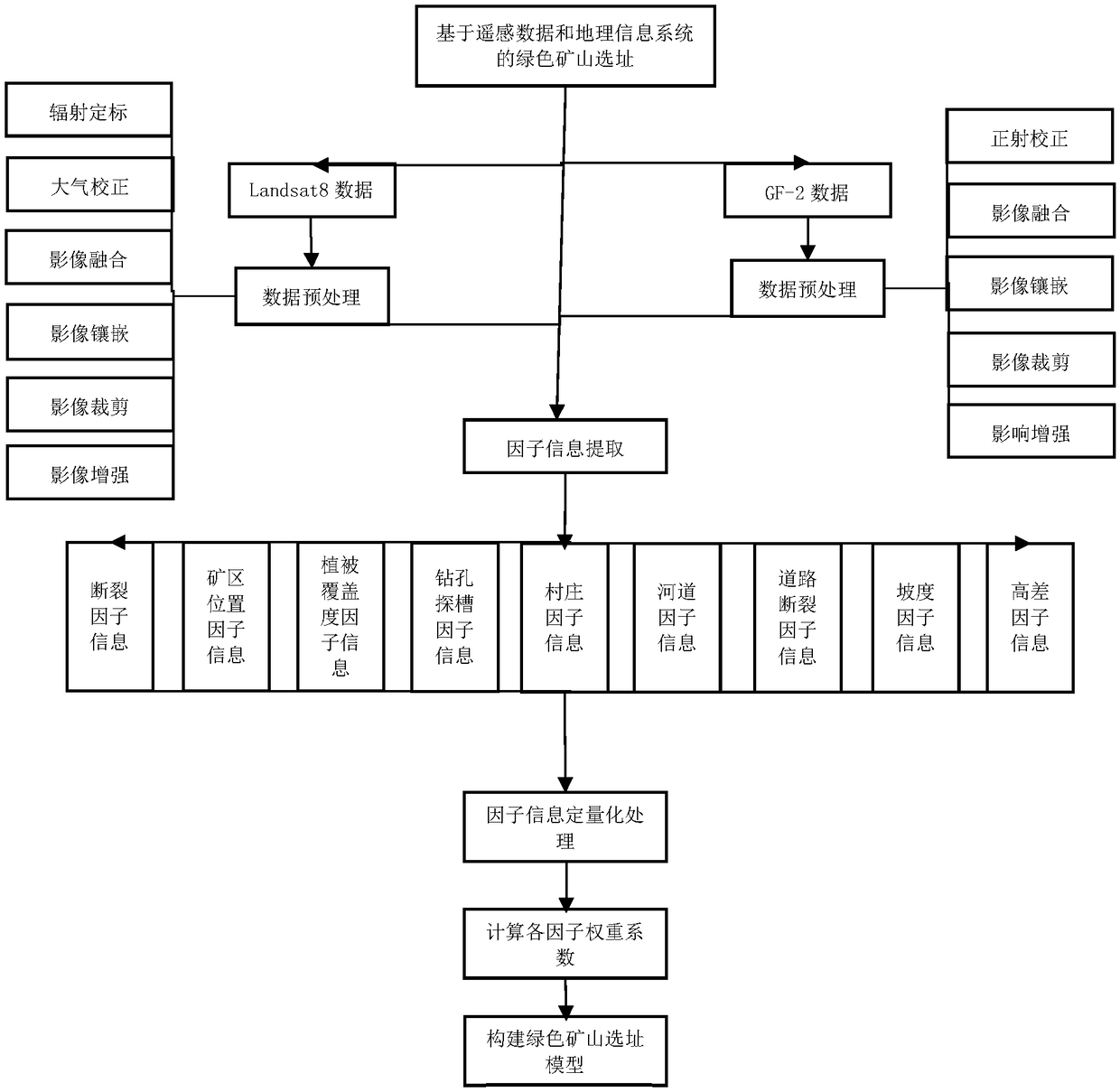
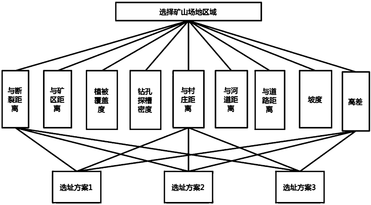
[0056] According to a preferred embodiment of the present invention, a kind of green mine site selection method based on remote sensing data and geographic information system is provided, such as figure 1 shown, including the following steps:

[0057] Obtain and preprocess the remote sensing image data of the area to be studied;

[0058] Extract the factor information of the preprocessed remote sensing image data;

[0059] Quantitatively process the extracted factor information;

[0060] Calculate the weight coefficient ...


PUM


Abstract

The invention discloses a green mine location selection method based on remote sensing data and geographic information system. The method comprises the following steps: obtaining remote sensing imagedata of an area to be studied and performing pretreatment; extracting factor information of the preprocessed remote sensing image data; quantitatively processing the extracted factor information; calculating the weight coefficients of quantified factor information and constructing the linear model of mine site selection. Wherein the factor information is selected from the group consisting of faultstructures, mining area locations, vegetation coverage, boreholes and grooves, villages, rivers, roads, gradients and height differences. The invention provides a green mine site selection method based on remote sensing data and geographic information system, which enables remote sensing data to play an important role in green mine construction by utilizing remote sensing information extraction technology, combining powerful spatial analysis functions of GIS such as spatial superposition, buffer analysis and the like, and providing assistance for green mine site selection.

Description

technical field [0001] The invention relates to the technical field of geological survey. More specifically, it relates to a green mine site selection method based on remote sensing data and geographic information system. Background technique [0002] Mineral resources are an important material basis for human survival, construction and development. The large-scale development and utilization of minerals has greatly promoted the development of human economy and society, and has also brought about a series of negative effects such as environmental pollution, landmark subsidence, mine earthquakes, etc. Mineral development and environmental maintenance are major issues facing the world today. Reasonable, orderly and safe development of mineral resources is the guarantee for maintaining economic growth and maintaining the ecological environment. [0003] Although some mining areas are rich in resource reserves, due to their special location, high altitude, severe cold and drou...

Claims


Application Information

Patent Timeline
Patent Type & Authority Applications(China)
IPC IPC(8): G06Q10/06G06Q50/02G06T7/00
Inventor 代晶晶
Owner INST OF MINERAL RESOURCES CHINESE ACAD OF GEOLOGICAL SCI
Why Eureka
Try Eureka