Building map construction method and platform oriented to catastrophe insurance

A technology of map construction and housing, applied in the field of building information processing, can solve problems such as large differences in classification types and difficult classification applicability to meet needs

Active Publication Date: 2019-01-29
INST OF GEOPHYSICS CHINA EARTHQUAKE ADMINISTRATION
View PDF6 Cites 1 Cited by
  • Summary
  • Abstract
  • Description
  • Claims
  • Application Information

AI Technical Summary

Problems solved by technology

[0003] Currently there are various national standards, such as "GB/T 19428-2013 Technical Specifications for Earthquake Disaster Prediction and Information Management System", "GB/T 18208 Earthquake Field Work" (Part 2/3/4), "GB/T 50011-2010 Code for Seismic Design of Buildings and GB 50352-2005 General Rules for Design of Civil Buildings, etc., all involve the classification of building types. T

Method used


Image

  • Building map construction method and platform oriented to catastrophe insurance
  • Building map construction method and platform oriented to catastrophe insurance
  • Building map construction method and platform oriented to catastrophe insurance

Examples


Embodiment 1

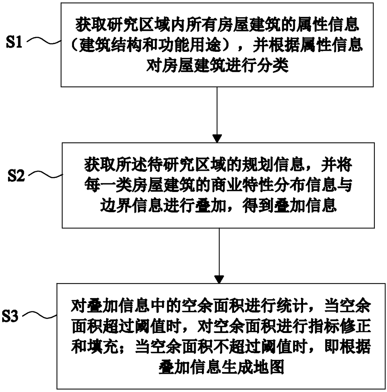
[0055] Such as figure 1 As shown, Embodiment 1 of the present invention provides a method for building a house map for catastrophe insurance, including the following steps:

[0056] S1: Obtain the attribute information of all buildings in the area to be studied, the attribute information includes the building structure and functional use of the buildings, and classify the buildings according to the attribute information;

[0057] Architectural structures include frame structures, brick-concrete structures, stone-wood structures, civil-wood structures, etc. Functional uses include commercial, educational, industrial, residential, medical, etc. The structural types and uses of all buildings that appear in the research area can be counted in The above information can be obtained by means of web crawler technology (for example, obtained from a network map), big data mining technology, etc., so as to comprehensively and systematically classify houses and buildings according to attr...

Embodiment 2

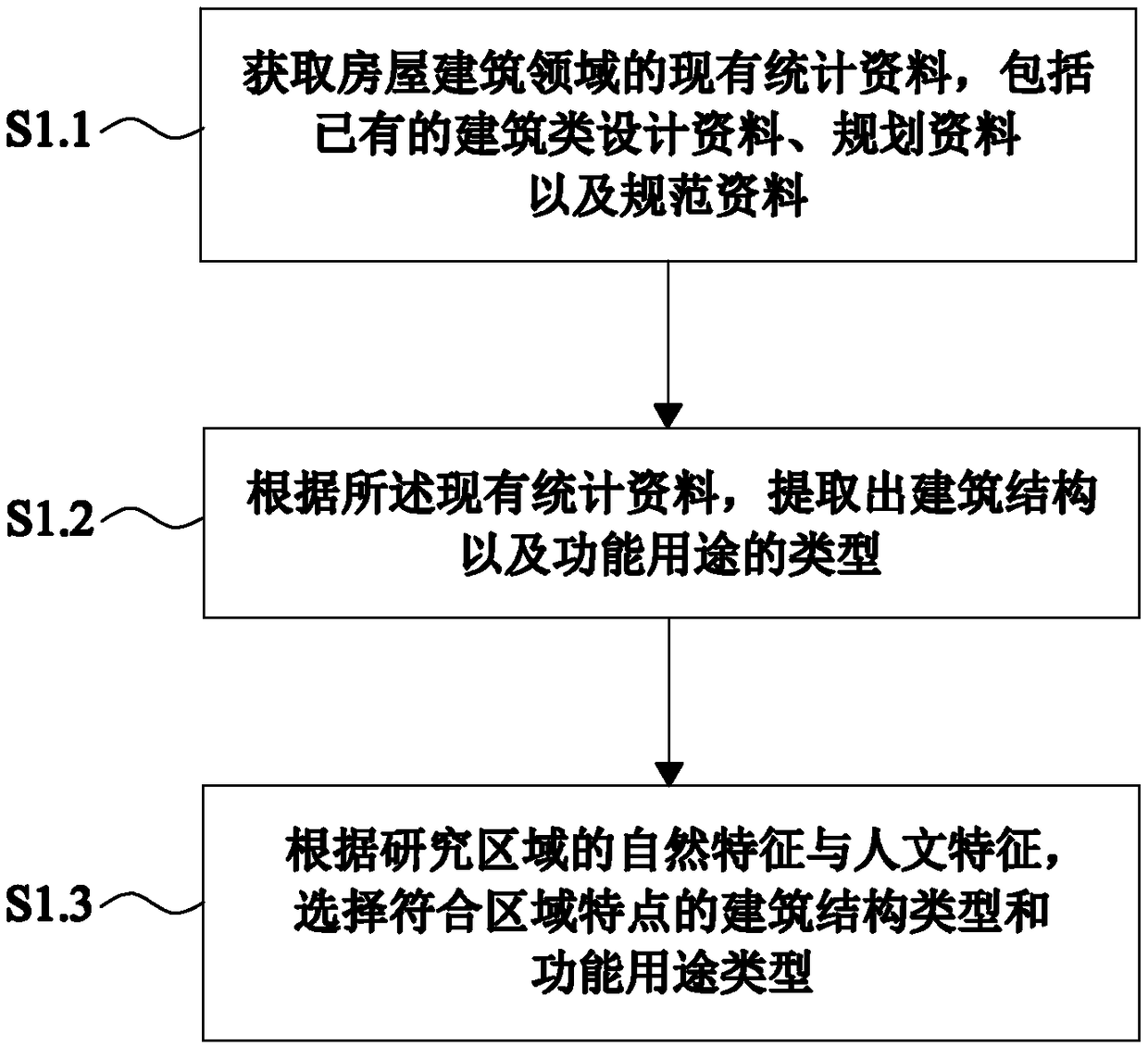
[0063] Such as figure 2 As shown, this embodiment 2 provides a catastrophe insurance-oriented building map construction method on the basis of embodiment 1, and this embodiment 2 further defines the specific method of step S1 as follows:

[0064] S1.1: Obtain the existing statistical data in the field of housing construction. The existing statistical data include existing architectural design data (building structure characteristics data in the United States, Japan and other countries or regions), planning data (planning and design data in various places) Drawings, written materials, etc.) and normative materials (various laws and regulations related to the construction industry, design standards, operating specifications, etc.);

[0065] S1.2: According to the existing statistical data, extract the type of the building structure and the functional use;

[0066] Obtaining the building structure and functional use from existing data can directly use the naming methods and cla...

Embodiment 3

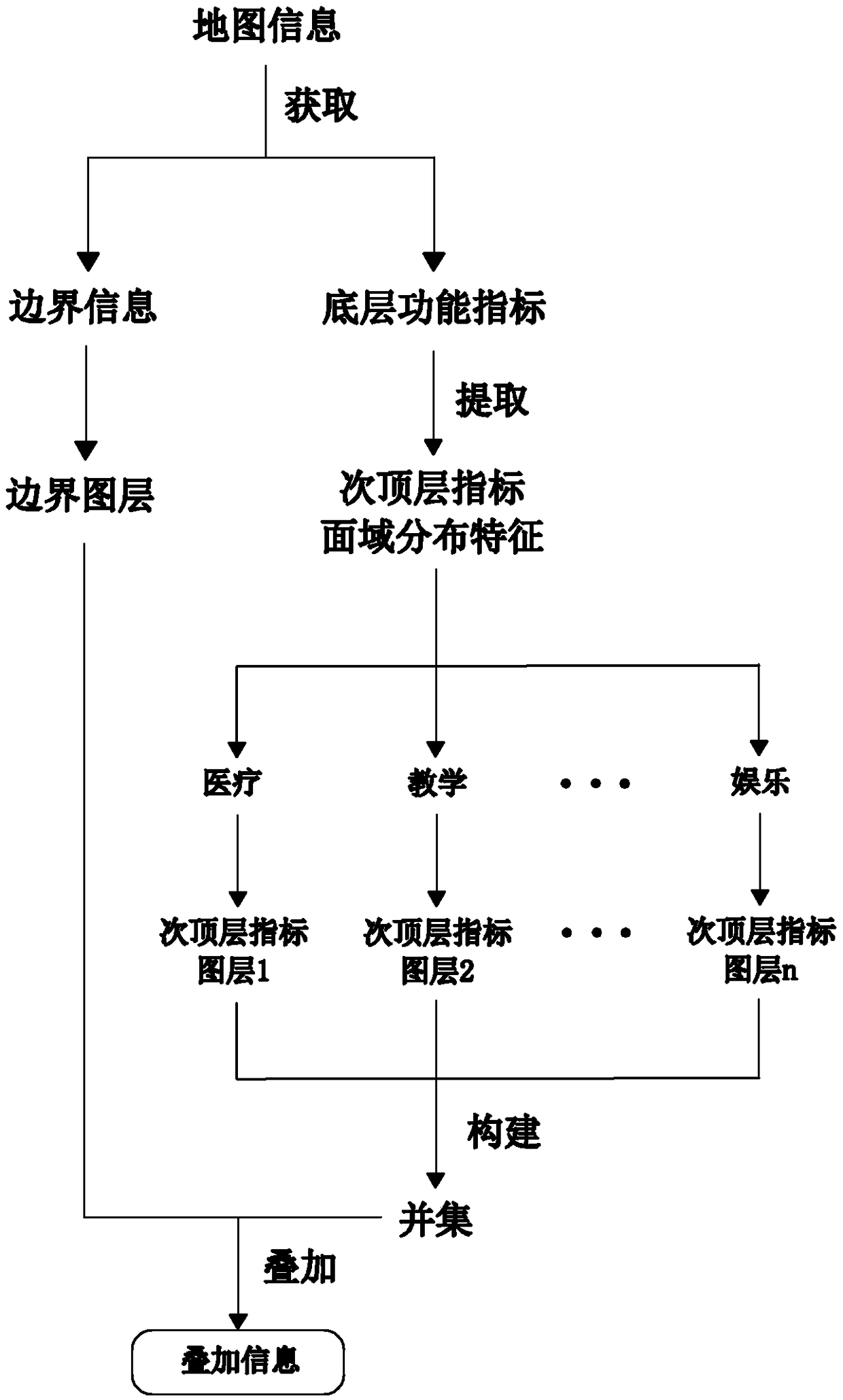
[0074] Such as Figure 5 As shown, on the basis of embodiment 1, this embodiment 3 provides a building map construction method for catastrophe insurance, and this embodiment 3 further defines the specific method of step S3 as follows:

[0075] S3.1: Make statistics on the vacant area in the superimposed information, and compare it with the total boundary area of ​​the area to be studied, and calculate the vacant area ratio;

[0076] S3.2: When the free area ratio is <10%, generate a thematic map directly according to the superimposed information;

[0077] S3.3: When the vacant area ratio is ≥10%, perform secondary collection on the spatial distribution information of the underlying functional indicators, and perform index correction on the commercial characteristic distribution information of the building according to the information collected twice , to fill the vacant area, so as to generate new superimposed information; until the vacant area ratio falls below 10%, then gen...


PUM


Abstract

The invention provides a building map construction method oriented to catastrophe insurance, which fully considers the demand of earthquake catastrophe insurance, and comprehensively and systematically classifies the buildings of our country from the viewpoint of structure and function. Geographic information system (GIS) technology, Web crawler technology and big data mining technology are utilized in combination with the specific house distribution and attribute data of the target city (or region), a building classification system with regional characteristics is coupled, and the building information query and analysis platform of typical urban districts of important cities in China is formed, and the regional map which can reflect the building classification and distribution of a specific region is completed. This method classifies and counts the buildings in local area and builds a map, obtains the real house attribute information of city or region through multi-source data and presents it, which can provide effective reference for the following disaster research, architectural design and insurance rule making and so on.

Description

technical field [0001] The invention belongs to the technical field of building information processing, and in particular relates to a building map construction method and platform for catastrophe insurance. Background technique [0002] Our country has a vast territory and diverse terrain, so natural disasters occur frequently. Especially because my country is located between the two major seismic belts in the world - the circum-Pacific seismic belt and the Eurasian seismic belt, the earthquakes in my country have the characteristics of high frequency, high intensity, shallow focus and wide distribution. Frequent natural disasters (especially earthquakes) have caused very serious damage to buildings, not only produced huge economic losses, but also caused many extremely serious social problems. In the past, most of the compensation funds for earthquake disasters in my country were provided by the government. The coverage was small and the efficiency was not high, and it ca...

Claims


Application Information

Patent Timeline
IPC IPC(8): G06F16/29G06Q40/08G06Q50/08
CPCG06Q40/08G06Q50/08
Inventor 戴志军李小军陈苏熊政辉周越高爽郑经纬
Owner INST OF GEOPHYSICS CHINA EARTHQUAKE ADMINISTRATION
Why Eureka
Try Eureka