A Deblurring Method of Remote Sensing Image Based on Dark Channel

A remote sensing image and deblurring technology, applied in the field of image processing, can solve the problems of not considering the characteristics of remote sensing imaging, inaccurate estimation of the PSF kernel value of the non-blind processing transition deblurring method, etc., and achieve the effect of a high degree of automatic processing.

Active Publication Date: 2021-09-07
BEIJING RES INST OF SPATIAL MECHANICAL & ELECTRICAL TECH
View PDF5 Cites 0 Cited by
  • Summary
  • Abstract
  • Description
  • Claims
  • Application Information

AI Technical Summary

Problems solved by technology

[0009] The technical problem solved by the present invention is: in the current prior art, in the process of repairing large-scale fuzzy remote sensing images combined with imaging parameter conditions, non-blind processing transitions that are prone to occur, and the PSF kernel value estimation of the deblurring method is not accurate and relies too much on Conditions do not consider the characteristics of remote sensing imaging, and propose a remote sensing image deblurring method based on dark channels

Method used


Image

  • A Deblurring Method of Remote Sensing Image Based on Dark Channel
  • A Deblurring Method of Remote Sensing Image Based on Dark Channel
  • A Deblurring Method of Remote Sensing Image Based on Dark Channel

Examples


Embodiment Construction

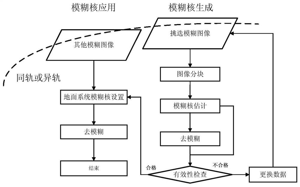
[0046] A remote sensing image deblurring method based on dark channel, such as figure 1 As shown, the specific steps are as follows:

[0047] (1) Select a fuzzy image I with a certain surface object from the satellite image data of the in-orbit image fuzzy phenomenon blur As the image to be processed, the fuzzy image I with certain features is selected blur The weather in the selected area must be sunny, and the atmospheric transmittance should not be lower than 0.6;

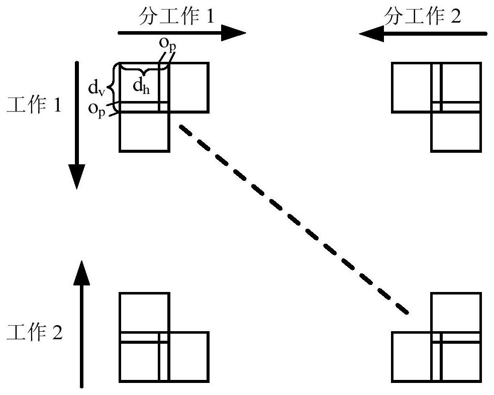
[0048] (2) Set the upper limit k of the fuzzy kernel of the remote sensing satellite image max is a fixed value, and at the same time for the blurred image I blur Carry out image block, to fuzzy image I blur The specific method for image segmentation is as follows:

[0049] For blurred images I blur Perform image block processing from bottom to top, from top to bottom, from left to right, and from right to left, where the size of the block processing is set to d h × d v ,Such as figure 2 As shown, the ...


PUM


Abstract

A dark channel-based remote sensing image deblurring method, for large-scale fuzzy remote sensing images, combined with imaging parameter conditions, corrects the prior use defects of existing dark channel methods on remote sensing images, and proposes a non-blind restoration that guarantees image details It overcomes the difficulties of blur kernel estimation and result smoothing, and does not depend on specific image features. At the same time, the deblurring result maintains the geometric structure information in the image, improves the level of visual understanding, and takes into account the production requirements of remote sensing images. The processing of size remote sensing images is stable and reliable.

Description

technical field [0001] The invention relates to a dark channel-based remote sensing image deblurring method, which belongs to the field of image processing. Background technique [0002] Due to atmospheric effects, platform jitter and / or the mismatch between integration time and satellite flight speed, the images acquired by remote sensing cameras are blurred to varying degrees, especially when the imaging system reaches the end of periodic calibration. obvious. Blurring effects can degrade the image quality, greatly affecting the user's visual interpretation ability and expert interpretation results. The image results after deblurring can support the restoration of observation information in the case of poor weather or bad viewing angles, and can be used in special imaging occasions such as major disaster observations. Therefore, how to remove image blur has become the focus of research in the past few decades. [0003] For a long time, researchers have attributed the pr...

Claims


Application Information

Patent Timeline
Patent Type & Authority Patents(China)
IPC IPC(8): G06T5/00G06T7/10G06T3/40
CPCG06T3/4038G06T5/003G06T2207/10032G06T2207/20021G06T7/10
Inventor 曹世翔谭伟邢坤何红艳
Owner BEIJING RES INST OF SPATIAL MECHANICAL & ELECTRICAL TECH
Why Eureka
Try Eureka