Route planning method, device, equipment and storage medium in work area
A technology for operating area and route planning, applied in vehicle position/route/height control, three-dimensional position/channel control, non-electric variable control, etc., can solve problems such as low operating efficiency and increased labor costs
- Summary
- Abstract
- Description
- Claims
- Application Information
AI Technical Summary
Problems solved by technology
Method used
Image
Examples
Embodiment 1
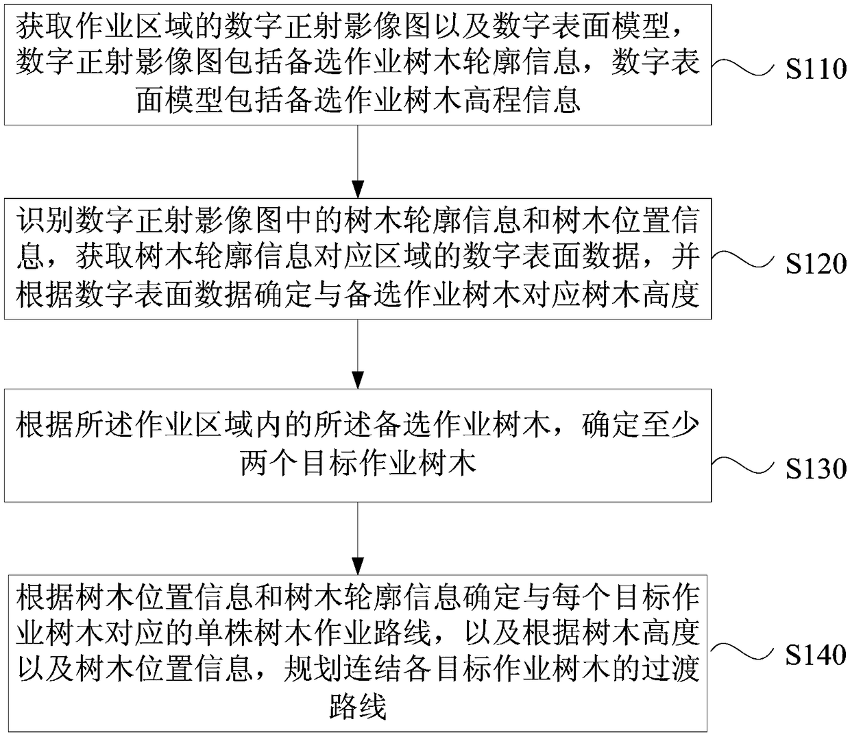
[0106] figure 1 It is a flowchart of a route planning method in an operation area provided by Embodiment 1 of the present invention. This embodiment can be applied to intelligently obtain the tree position information and tree height of the target operation tree in the operation area, and plan the route planning method in the operation area. In the case of the operation route for the target operation tree in the area, the method can be executed by the route planning device in the operation area, which can be implemented by software and / or hardware, and can generally be integrated into a server or terminal device In the middle, it is used in conjunction with the operation drone. Correspondingly, such as figure 1 As shown, the method includes the following operations:
[0107] S110. Acquire a digital orthophoto image and a digital surface model of the operation area, the digital orthophoto image includes outline information of candidate operating trees, and the digital surface...
Embodiment 2
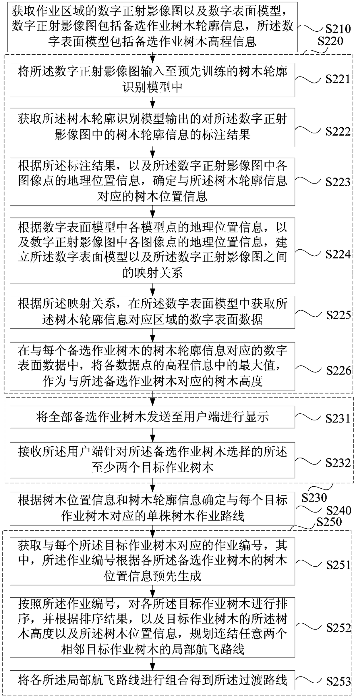
[0132] Figure 2a It is a flow chart of a route planning method in an operation area provided by Embodiment 2 of the present invention. This embodiment is embodied on the basis of the above-mentioned embodiments. In this embodiment, the method for identifying the digital orthophoto The tree outline information and tree position information in the figure, the digital surface model data of the area corresponding to the tree outline information is obtained in the digital surface model, and the tree corresponding to each candidate operation tree is determined according to the digital surface model data The tree height, and according to the tree height and the tree position information, a specific implementation method of planning a transition route connecting each of the target operation trees. Correspondingly, such as Figure 2a As shown, the method of this embodiment may include:
[0133] S210. Acquire a digital orthophoto image and a digital surface model of the operation are...
Embodiment 3
[0177] Figure 3a It is a flowchart of a route planning method in an operation area provided by Embodiment 3 of the present invention. This embodiment is embodied on the basis of the above embodiments. The tree height and the tree position information of the tree plan a specific implementation of a local flight route connecting any two adjacent target operation trees. Correspondingly, such as Figure 3a As shown, the method of this embodiment may include:
[0178] S310. Acquire a digital orthophoto image and a digital surface model of the operation area, the digital orthophoto image includes outline information of candidate operating trees, and the digital surface model includes elevation information of candidate operating trees.
[0179] S320. Identify the tree outline information and tree position information in the digital orthophoto image, acquire the digital surface model data of the area corresponding to the tree outline information in the digital surface model, and de...
PUM
 Abstract
Description
Claims
Application Information
 - R&D
- Intellectual Property
- Life Sciences
- Materials
- Tech Scout
- Unparalleled Data Quality
- Higher Quality Content
- 60% Fewer Hallucinations
Browse by: Latest US Patents, China's latest patents, Technical Efficacy Thesaurus, Application Domain, Technology Topic, Popular Technical Reports.
© 2025 PatSnap. All rights reserved.Legal|Privacy policy|Modern Slavery Act Transparency Statement|Sitemap|About US| Contact US: help@patsnap.com


