A comprehensive monitoring method for regional road traffic system of cross-scale space-based platform

A road traffic and system integration technology, applied in the field of aerial surveillance, can solve the problems of long shooting distance and small targets of vehicles and pedestrians, and achieve the effect of reducing installation and maintenance costs and manpower input

Active Publication Date: 2020-03-06
BEIHANG UNIV
View PDF15 Cites 0 Cited by
  • Summary
  • Abstract
  • Description
  • Claims
  • Application Information

AI Technical Summary

Problems solved by technology

[0005] However, the space-based platform surveillance methods for regional road traffic systems face many challenges: First, most of the space-based platform surveillance methods use unmanned aerial vehicles or airships with cameras, and the shooting distance is generally long. Vehicles and pedestrians in the video Targets are relatively small, placing high demands on the accuracy of surveillance methods

Method used


Image

  • A comprehensive monitoring method for regional road traffic system of cross-scale space-based platform
  • A comprehensive monitoring method for regional road traffic system of cross-scale space-based platform

Examples


Embodiment Construction

[0039] The present invention will be further described in detail with reference to the accompanying drawings and embodiments.

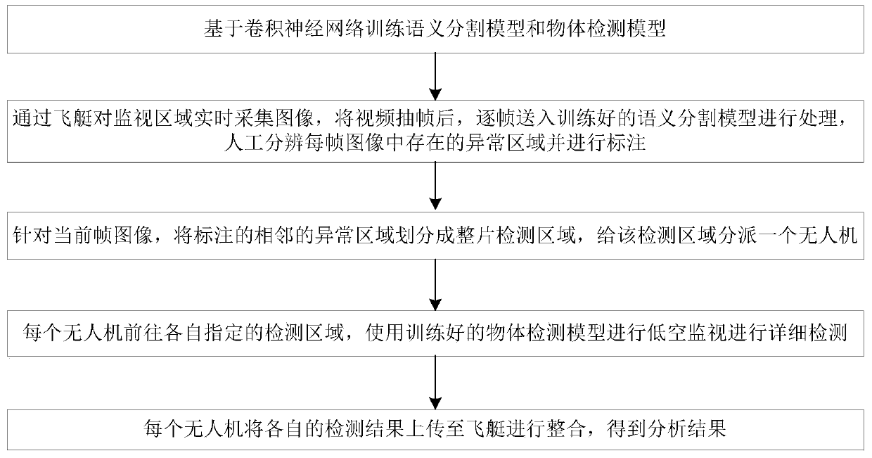
[0040] The invention provides a realization method of a cross-scale space-based platform integrated monitoring system oriented to regional road traffic systems. The normal operation of regional road traffic systems requires sufficient monitoring, such as early warning and dredging of road congestion, traffic accident alarms, and tracking of hit and run, etc. Wait. The traditional roadbed monitoring method has many disadvantages. First, the location of the monitoring equipment is fixed; the monitoring cost is high, a large number of equipment needs to be installed, and it cannot achieve full coverage of the monitoring area, such as traffic cameras. Therefore, in view of the above drawbacks, the present invention conducts rough and detailed monitoring of the monitoring area through the cooperation of the airship and the unmanned aerial vehicle, thereby ...


PUM


Abstract

The invention discloses a comprehensive monitoring method for a regional road traffic system in a cross-scale aerial platform and belongs to the field of aviation monitoring. The method specifically comprises steps that firstly, a semantic segmentation model and an object detection model are trained based on the convolutional neural network; images are acquired by an airship in real time in the monitoring area, a video after frame extracting is sent to the semantic segmentation model frame by frame for processing, and abnormal regions existing in each frame image are manually distinguished andlabeled; secondly, for a current frame image, the labeled adjacent abnormal regions are merged into a whole piece detection region, and a drone is assigned to the detection area; each drone goes to adesignated detection area, and the object detection model is utilized to perform detailed detection of low-altitude monitoring; and lastly, the abnormal position is determined, messages are uploadedand returned back to the airship, and corresponding warning or processing is performed. The method is advantaged in that through a cooperative work mode of the airship and the drone, the monitoring area is monitored roughly and in details, and complete coverage of the monitoring area is realized through relatively small cost.

Description

technical field [0001] The invention belongs to the field of aviation surveillance, and in particular relates to a method for comprehensive surveillance of a cross-scale space-based platform regional road traffic system. Background technique [0002] Road monitoring is mainly based on fast dome monitoring. The monitoring points are distributed at road intersections and key road sections where traffic and people flow are relatively concentrated. Regional road conditions in order to adjust the flow of vehicles at each intersection to ensure smooth traffic. In addition, it can detect and arrange to deal with road traffic accidents in a timely manner for monitoring violations of road vehicles, provide technical support for the detection of various cases such as traffic and public security, and greatly improve the level and efficiency of public security organs in law enforcement and case handling. [0003] Traditional road traffic monitoring is mostly roadbed monitoring, by plac...

Claims


Application Information

Patent Timeline
Patent Type & Authority Patents(China)
IPC IPC(8): G08G1/01H04N7/18
CPCG08G1/0125G08G1/0137G08G1/0145H04N7/181
Inventor 曹先彬甄先通李岩王昊臣胡宇韬
Owner BEIHANG UNIV
Why Eureka
Try Eureka