Image and radio frequency communication data fused parcel map automatic generation method

A technology of radio frequency communication and data fusion, applied in photogrammetry/video metrology, surveying and navigation, measuring devices, etc., can solve problems such as low efficiency, manual identification of boundaries, and data collection errors, so as to improve accuracy and efficiency , the effect of reducing registration costs

Active Publication Date: 2019-05-17
SOUTHEAST UNIV
View PDF4 Cites 6 Cited by
  • Summary
  • Abstract
  • Description
  • Claims
  • Application Information

AI Technical Summary

Problems solved by technology

[0006] The technical problem to be solved by the present invention is to overcome the problems of data acquisition errors and low efficiency in the existing rural homestead registration work, and provide a method for automatically generating parcel maps by fusion of image and radio frequency communication data, and automatically matching drones The met

Method used


Image

  • Image and radio frequency communication data fused parcel map automatic generation method
  • Image and radio frequency communication data fused parcel map automatic generation method

Examples


Embodiment Construction

[0023] Embodiments of the present invention will be described below in conjunction with the accompanying drawings.

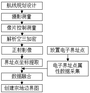
[0024] The present invention designs a method for automatically generating parcel maps by fusion of images and radio frequency communication data. The method takes rural homestead map drawing as an example, as figure 1 As shown, the method specifically includes the following steps:

[0025] Step 1. First, assign several electronic boundary points to each resident, and each household resident carries out independent and continuous numbering on the allocated electronic boundary points, and obtains the serial number of the parcel and the serial number of the boundary point of the resident and stores them in each Electronic boundary point; the electronic boundary point allocated to each household is numbered independently, denoted as Jx 1 , Jx 2 ,…Jx N , where X is the serial number of the exclusive parcel of residents that is different from other households, one...


PUM


Abstract

The invention discloses an image and radio frequency communication data fused parcel map automatic generation method. The image and radio frequency communication data fused parcel map automatic generation method comprises the steps that a plurality of electrical boundary points are allocated to all households, and serial numbers of the electrical boundary points and land attribute information of all households are written in the electrical boundary points; the electrical boundary points are placed in order according to the land scopes of all households, and radio frequency communication signals are controlled to be transmitted; ortho-photo images are acquired through aerial photo of an unmanned aerial vehicle and treatment, and location coordinates of the electrical boundary points are extracted; the radio frequency communication signals transmitted by the electrical boundary points are received; according to the location coordinates of the electrical boundary points in the ortho-photoimages mapping to the radio frequency communication signals, an SURF algorithm is used for matching the placing order of the electrical boundary points and the land attribute information of all households, connecting is conducted according to the order of the serial numbers, and a panel is formed by boundary points wiring, and thus parcel maps of all households are acquired. According to the image and radio frequency communication data fused parcel map automatic generation method, the workload of household-entry boundary identifying carrying out of house site authentic right can be reduced, and accuracy and high efficiency of confirmation of land right are achieved.

Description

technical field [0001] The invention relates to a method for automatically generating parcel maps for fusion of image and radio frequency communication data, and belongs to the technical field of fusion of multi-source data. Background technique [0002] Land is the foundation of a country and is of great significance to the construction of the national economy and the harmonious development of society. With the steady advancement and development of social construction in our country, the problem of unclear property rights of rural homesteads needs to be resolved urgently. Through the confirmation and registration of rural homesteads, a series of disputes caused by ownership issues can be effectively avoided. How to fill in the area of ​​the homestead when registering the homestead is an important aspect of the ownership review. There is an urgent need for an accurate and efficient technical means to complete the collection and mapping of homestead information. [0003] At ...

Claims


Application Information

Patent Timeline
IPC IPC(8): G01C11/00
Inventor 王庆韩冷阳媛吴向阳
Owner SOUTHEAST UNIV
Why Eureka
Try Eureka