A cesium-based network three-dimensional electronic map construction method

An electronic map and construction method technology, applied in 3D modeling, image data processing, instruments, etc., can solve problems such as poor fluency and rough model, and achieve the effect of improving intuitive feeling, maintaining consistency, and improving user experience

Inactive Publication Date: 2021-04-20
NANJING UNIV OF TECH +1
View PDF10 Cites 0 Cited by
  • Summary
  • Abstract
  • Description
  • Claims
  • Application Information

AI Technical Summary

Problems solved by technology

[0004] The purpose of the present invention is to provide a Cesium-based network three-dimensional electronic map construction method to solve the problem that WebGIS is limited to two-dimensional object display and the traditi

Method used


Image

  • A cesium-based network three-dimensional electronic map construction method

Examples


Embodiment 1

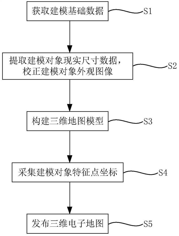
[0029] like figure 1 As shown, a Cesium-based network three-dimensional electronic map construction method includes the following steps:

[0030] Step S1: Collect and obtain basic modeling data

[0031] The basic modeling data includes the construction drawings of the modeling object, the appearance image of the modeling object and the topographic map of the modeling area. The construction drawing of the model object is the basis of modeling. Model construction is carried out by extracting key information from the drawing, which has an important impact on the fineness of the model. In order to ensure the quality of the data, it can be compared with the field measurement data of the modeling object; the appearance image of the modeling object The quality of the model determines the quality of the texture of the model; the topographic map of the modeling area determines the quality of model integration and the creation of the regional environment. In order to ensure the quality...


PUM


Abstract

The present invention provides a Cesium-based network three-dimensional electronic map construction method, comprising the following steps: collecting and obtaining modeling basic data; Correct the image; build a 3D map model; collect the coordinates of the feature points of the modeling object; publish a 3D electronic map. The network three-dimensional electronic map constructed based on Cesium in the present invention can overcome the limitation that WebGIS is limited to two-dimensional feature display, and can express layered features such as elevated roads; further, Cesium performs hardware acceleration through WebGL, and its hardware requirements are low. And because Cesium open source and custom-made browsing special effects can guarantee the fluency in the browsing process, improve user experience; Furthermore, the three-dimensional map model in the present invention is based on the construction drawing of the modeling object, the appearance image of the modeling object and the topography of the modeling area The actual data of the map is constructed, so the complete solid model of the 3D map formed is more accurate.

Description

technical field [0001] The invention relates to the technical field of three-dimensional map construction, in particular to a Cesium-based network three-dimensional electronic map construction method. Background technique [0002] With the improvement of living standards, location-based services have become an indispensable part of people's daily life. As the cornerstone of location-based services, electronic maps provide intuitive location information for the public. With the development of GIS, the expansion of GIS through the Internet, that is, WebGIS (Web Geographic Information System), has become a convenient tool for the public to obtain location services. There are many limitations in the existing WebGIS. Most WebGIS mainly deal with two-dimensional data models, which are difficult to meet people's needs for comprehensive cognition of ground objects and grasping spatial positions. However, there are models in the use of traditional network three-dimensional electronic...

Claims


Application Information

Patent Timeline
IPC IPC(8): G06T17/05
Inventor 李明峰赵黎晨檀丁王婷婷黄吴浩刘雯雯陈小翠
Owner NANJING UNIV OF TECH
Why Eureka
Try Eureka