
Vehicle positioning method

A vehicle positioning and vehicle technology, applied in satellite radio beacon positioning systems, measuring devices, instruments, etc., can solve the problems of feature matching process influence, influence positioning accuracy, image blurring, etc., achieve high adaptability, improve positioning accuracy, The effect of improving reliability and positioning accuracy

Active Publication Date: 2019-05-28
BEIJING UNIV OF POSTS & TELECOMM
View PDF6 Cites 12 Cited by
  • Summary
  • Abstract
  • Description
  • Claims
  • Application Information

AI Technical Summary

Problems solved by technology

[0005] In addition, there is a more common limiting factor in map-based vehicle location technology
During the driving process of the vehicle, due to factors such as camera shake and insufficient lighting, the collected images will be blurred to a certain extent, which will have some impact on the feature matching process, thereby affecting the positioning accuracy

Method used


Image

  • Vehicle positioning method
  • Vehicle positioning method
  • Vehicle positioning method

Examples


Embodiment Construction

[0018] In order to make the object, technical solution, and advantages of the present invention clearer, the present invention will be further described in detail below with reference to the accompanying drawings and examples.

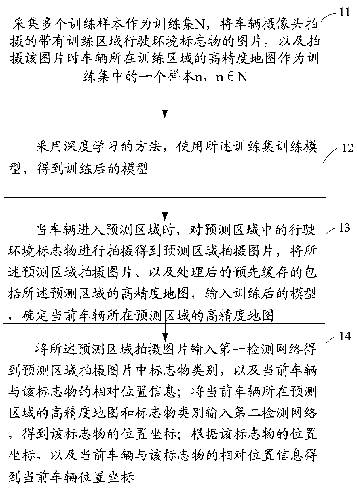
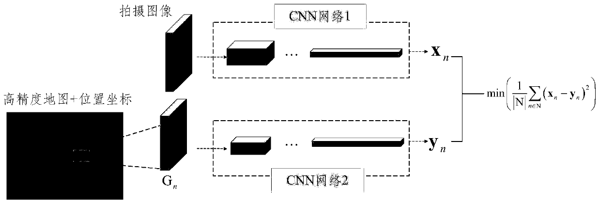
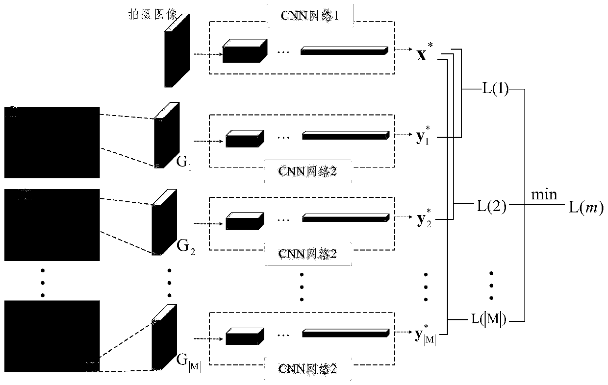
[0019] The invention proposes a vehicle positioning scheme based on machine learning and predicting location information based on images collected by cameras and high-precision maps. The positioning process does not completely depend on satellite signals, and vehicle positioning can be realized in environments where signals cannot be received. Utilize the self-learning, self-organizing and self-adaptive characteristics of the neural network, and at the same time solve the problems that the blurred image affects the positioning accuracy and the cumulative error generated during the positioning process. The scheme is divided into two stages: in the first stage, the vehicle downloads the high-precision map of the nearby area from the adjacent roadside unit...


PUM


Abstract

The invention discloses a vehicle positioning method which comprises the following steps: collecting a plurality of training samples as a training set N, and taking a picture with a training area driving environment marker shot by a vehicle camera and a high-precision map of a training area where a vehicle is located when the picture is shot as a sample n in the training set, wherein n belongs toN; adopting a deep learning method, the training set is used for training a model, and a trained model is obtained; when the vehicle enters the prediction area; shooting the driving environment markerin the prediction area to obtain a picture shot in the prediction area, inputting the picture shot in the prediction area and the processed high-precision map which is cached in advance and comprisesthe prediction area into the trained model, and determining the high-precision map of the prediction area where the current vehicle is located; And the current vehicle position coordinate is determined. By the adoption of the method and device, vehicle positioning in the environment where the positioning process does not completely depend on satellite signals and cannot receive the signals can beachieved.

Description

technical field [0001] The invention relates to the technical field of positioning, in particular to a vehicle positioning method. Background technique [0002] Vehicle positioning technology is an important technology in the field of intelligent autonomous driving, and the demand for high-precision and high-reliability vehicle positioning is increasing day by day. At present, the most widely used and most mature positioning technology is the Global Positioning System (GPS, Global Positioning System), which has the characteristics of high cost performance, simple deployment, and global coverage. On this basis, there are many improved enhancement technologies, such as real-time dynamic differential positioning, visual odometer, inertial navigation positioning, dead reckoning positioning, etc., which improve the positioning accuracy and positioning update frequency of the satellite positioning system to a certain extent. Today's GPS systems can provide very accurate position ...

Claims


Application Information

Patent Timeline
Patent Type & Authority Applications(China)
IPC IPC(8): G06F16/29G06K9/62G06K9/00G01S19/14G01S19/48
Inventor 赵龙刘杰关东郑侃
Owner BEIJING UNIV OF POSTS & TELECOMM
Learn More