Regional flood disaster risk evaluation and estimation method coupling GIS algorithm and GBDT algorithm

A flood disaster and risk assessment technology, applied in the direction of reservation, calculation, instrument, etc., can solve the problem of uneven time and space

Active Publication Date: 2019-06-07
HOHAI UNIV
View PDF5 Cites 36 Cited by
  • Summary
  • Abstract
  • Description
  • Claims
  • Application Information

AI Technical Summary

Problems solved by technology

Since the formation conditions of flood disasters in changing environments have the characteristics of temporal and spatial inhomogeneity and nonlinearity, the uncertainties in the flood disaster risk assessment index system and flood disaster risk assessment and prediction models have brought great challenges to the accurate assessment of regional flood disaster risk. big challenge

Method used


Image

  • Regional flood disaster risk evaluation and estimation method coupling GIS algorithm and GBDT algorithm
  • Regional flood disaster risk evaluation and estimation method coupling GIS algorithm and GBDT algorithm
  • Regional flood disaster risk evaluation and estimation method coupling GIS algorithm and GBDT algorithm

Examples


Embodiment Construction

[0044] The technical solutions of the present invention will be further specifically described below through the embodiments and in conjunction with the accompanying drawings.

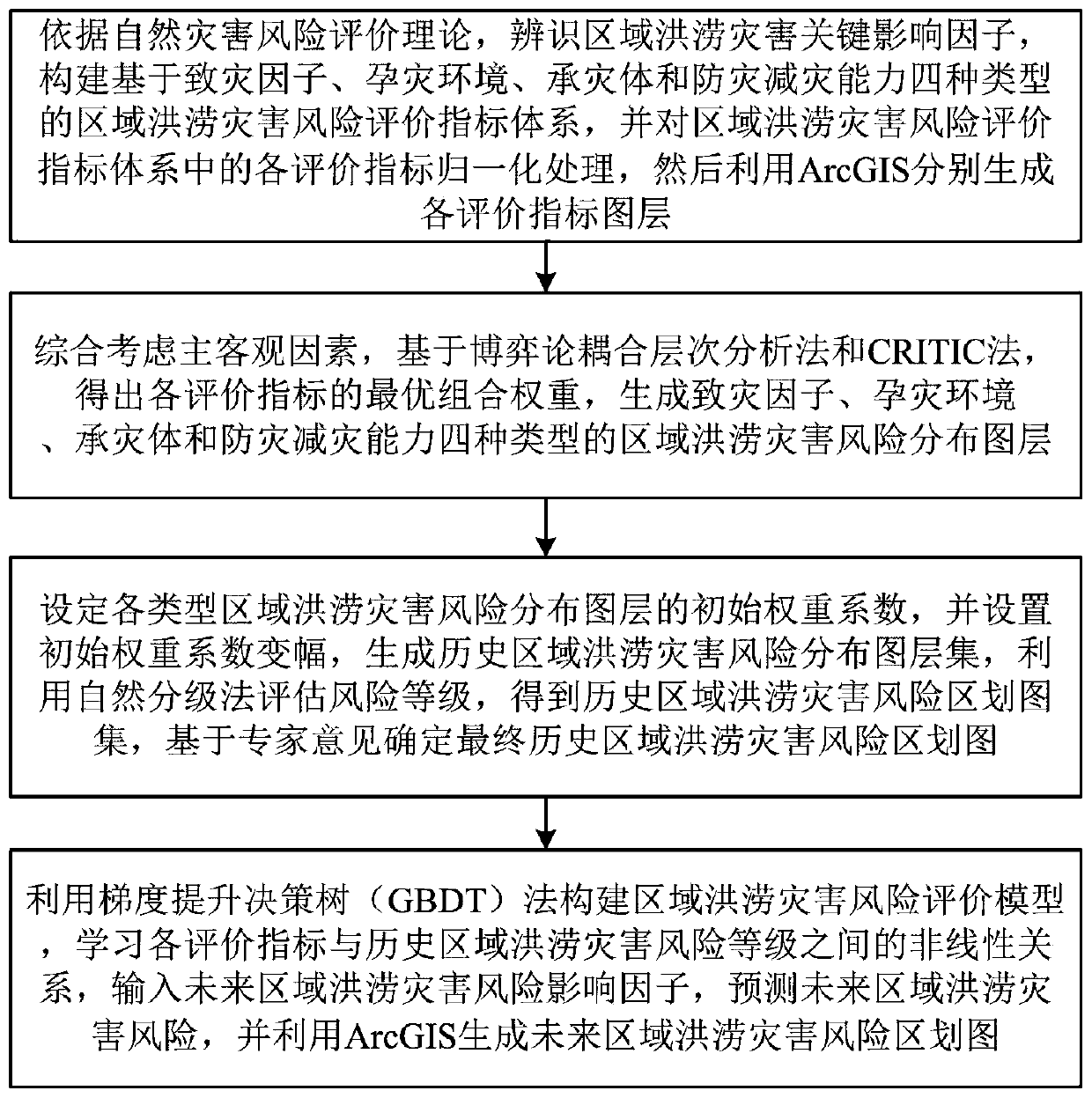
[0045] Such as figure 1 As shown, a regional flood disaster risk assessment and prediction method coupled with GIS (Geographic Information System) and GBDT (Gradient Boosting Decision Tree) algorithm includes the following steps:

[0046] Step 1: Based on the natural disaster risk assessment theory, identify the key factors affecting regional flood disasters, construct a regional flood disaster risk assessment index matrix based on four types of disaster-causing factors, disaster-forming environment, disaster-affected bodies, and disaster prevention and mitigation capabilities, and analyze the Each evaluation index in the regional flood disaster risk evaluation index system is normalized, and then ArcGIS (integrated GIS development tool) is used to generate each evaluation index layer respectively.

...


PUM


Abstract

The invention discloses a regional flood disaster risk evaluation and estimation method coupling a GIS algorithm and a GBDT algorithm. The method comprises the following steps: constructing a regionalflood disaster risk evaluation index system based on four types of disaster-causing factors, disaster-pregnant environments, disaster-bearing bodies and disaster prevention and reduction capacities,and normalizing the regional flood disaster risk evaluation index system to generate evaluation index layers; obtaining the optimal combination weight of each evaluation index, and generating four types of regional flood disaster risk distribution map layers; determining a final historical region flood disaster risk division map based on expert opinions; and constructing a regional flood disasterrisk evaluation model, predicting a future regional flood disaster risk, and generating a future regional flood disaster risk division map by using ArcGIS. The method has superiority for multivariatebig data processing, is suitable for basin or regional flood risk assessment and prediction, and can remarkably improve the calculation precision and the reliability of assessment and decision making.

Description

technical field [0001] The invention belongs to the field of water resources planning and management, and specifically relates to flood disaster risk assessment and management, in particular to a regional flood disaster risk assessment and prediction method coupled with GIS and GBDT algorithm. Background technique [0002] Flood disasters are sudden, frequent, and destructive natural disasters. Due to the dual impacts of climate change and human activities, their occurrence intensity and frequency have increased to varying degrees. Flood disaster risk assessment is a comprehensive evaluation of the natural and social attributes of regional flood disasters, and its purpose is to more accurately grasp the spatial distribution and internal mechanism of flood disaster risks. Since flood disaster risk assessment is affected by many factors such as nature, socio-economics, and engineering technology, the assessment process involves multiple assessment indicators. Existing methods ...

Claims


Application Information

Patent Timeline
Patent Type & Authority Applications(China)
IPC IPC(8): G06Q10/02G06Q50/26
CPCY02A10/40
Inventor 钟平安杨敏芝李洁玉刘为锋陈娟朱非林张宇付吉斯高益辉姚超宇李映辉
Owner HOHAI UNIV
Why Eureka
Try Eureka