County and country territory space planning optimization method and system

A space planning and optimization method technology, applied in the direction of instruments, data processing applications, forecasting, etc., can solve the problems that affect the sustainable development of coastal resources, do not meet other plans, regional arrangements, etc., to achieve intensive and efficient use The effect of reasonable and sustainable development

Inactive Publication Date: 2019-06-21
辽宁省国土资源调查规划局
View PDF4 Cites 8 Cited by
  • Summary
  • Abstract
  • Description
  • Claims
  • Application Information

AI Technical Summary

Problems solved by technology

[0002] At present, due to various reasons, land, planning, forestry and ocean management departments are not well connected in management, resulting in relatively large conflicts in land planning, urban planning, ecological and environmental protection planning, marine zoning and other related industry planning along the coastline. Each plan arranges different uses for the same area, resulting in some projects only conforming to one plan and not conforming to several other plans. In this case, it is necessary to modify the plans that do not comply. Effectiveness is seriously challenged
[0003] In addition, due to the different planning objectives, responsibilities and division of labor of various professional departments when prep

Method used


Image

  • County and country territory space planning optimization method and system
  • County and country territory space planning optimization method and system
  • County and country territory space planning optimization method and system

Examples


Embodiment Construction

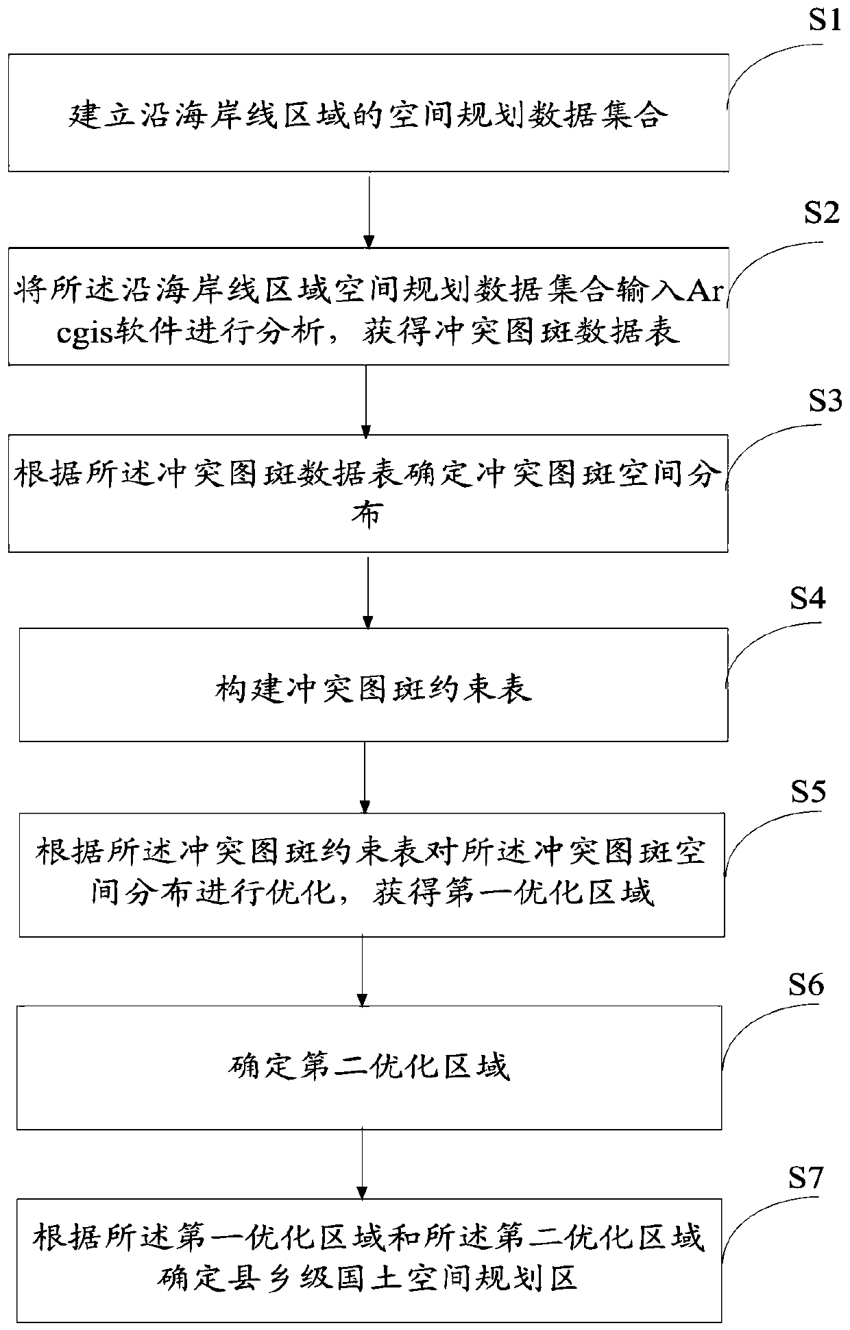
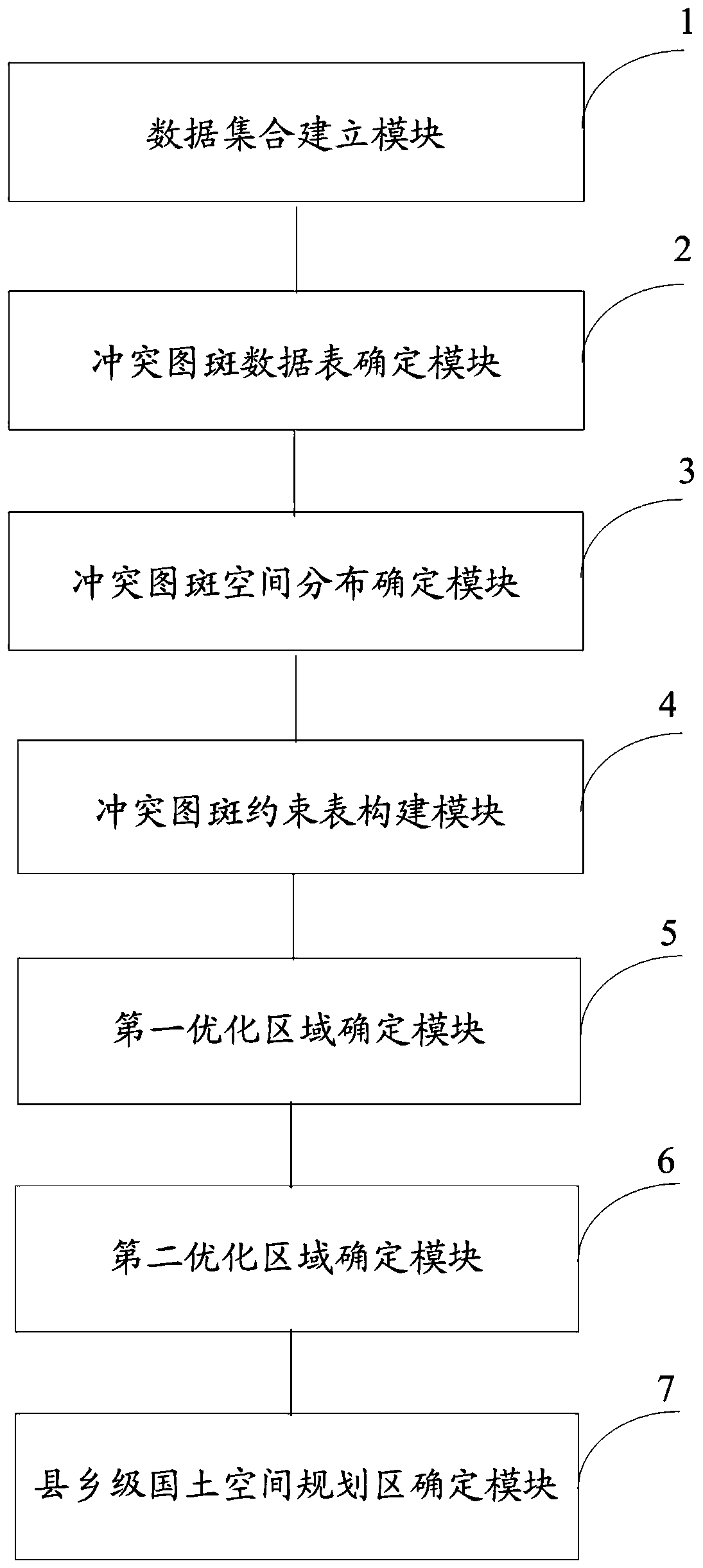
[0074] The following will clearly and completely describe the technical solutions in the embodiments of the present invention with reference to the accompanying drawings in the embodiments of the present invention. Obviously, the described embodiments are only some, not all, embodiments of the present invention. Based on the embodiments of the present invention, all other embodiments obtained by persons of ordinary skill in the art without making creative efforts belong to the protection scope of the present invention.

[0075] The purpose of the present invention is to provide a method and system for optimizing land space planning at the county and township level, so as to realize reasonable planning of land space at the county and township level and promote sustainable, healthy and reasonable utilization of the region.

[0076] In order to make the above objects, features and advantages of the present invention more comprehensible, the present invention will be further descri...


PUM


Abstract

The invention discloses a county and country territory space planning optimization method and system. The method comprises the steps that firstly,establishing a space planning data set along a coastline area; inputting the coastline area space planning data set into Arcgis software for analysis to obtain a conflict pattern spot data table; determining conflict pattern spot spatial distribution according to the conflict pattern spot data table; secondly, constructing a conflict graph spot constraint table; optimizing the spatial distribution of the conflict pattern spots according to the conflict pattern spot constraint table to obtain a first optimization area; determining a second optimization area; and finally, determining county and country territory space planning application areas according to the first optimization area and the second optimization area. The situation that due to the fact that all departments are lack of deep connection, area arrangement is considered, and finallythe utilization space layout along the coastline is unreasonable is avoided, and intensive and efficient utilization and reasonable and sustainable development of coastline resources are influenced.

Description

technical field [0001] The invention relates to the technical field of land space planning, in particular to a method and system for optimizing land space planning at county and township levels. Background technique [0002] At present, due to various reasons, land, planning, forestry and ocean management departments are not well connected in management, resulting in relatively large conflicts in land planning, urban planning, ecological and environmental protection planning, marine zoning and other related industry planning along the coastline. Each plan arranges different uses for the same area, resulting in some projects only conforming to one plan and not conforming to several other plans. In this case, it is necessary to modify the plans that do not comply. Efficacy has been seriously challenged. [0003] In addition, due to the different planning objectives, responsibilities and division of labor of various professional departments when preparing the plans of various ...

Claims


Application Information

Patent Timeline
IPC IPC(8): G06Q10/04G06Q50/26
Inventor 李洪兴石水莲王思琢李铁钢曲玮张春花崔伟关鹏闫雪松陈丹杨忠臣彭兵根甄实王国申潘锦华姜欢欢申娜荀秋扬闫长满
Owner 辽宁省国土资源调查规划局
Why Eureka
Try Eureka