Large-scale fire situation analysis system based on spatial positioning

A space positioning and analysis system technology, applied to services based on specific environments, used in forest fire alarms, transmission systems, etc., can solve the problems of not giving real-time monitoring and analysis of fires, and achieve low fire situation analysis and monitoring, The effect of low cost, real-time performance and accuracy

Active Publication Date: 2019-07-02
HEFEI UNIV OF TECH
View PDF10 Cites 10 Cited by
  • Summary
  • Abstract
  • Description
  • Claims
  • Application Information

AI Technical Summary

Problems solved by technology

Compared with the present invention, the application scenarios of these patents are only limited to forest fires, and there is no real-time monitoring and analysis scheme for the situation after the fire occurs

Method used


Image

  • Large-scale fire situation analysis system based on spatial positioning
  • Large-scale fire situation analysis system based on spatial positioning
  • Large-scale fire situation analysis system based on spatial positioning

Examples


Embodiment Construction

[0045] The present invention will be further described below in conjunction with drawings and embodiments. It should be understood that the specific embodiments described here are only used to explain the present invention, but not to limit the present invention. In addition, it should be noted that, for the convenience of description, only parts related to the present invention are shown in the drawings but not all content.

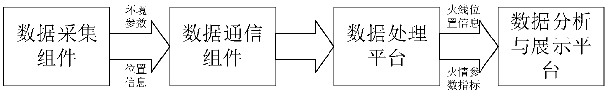
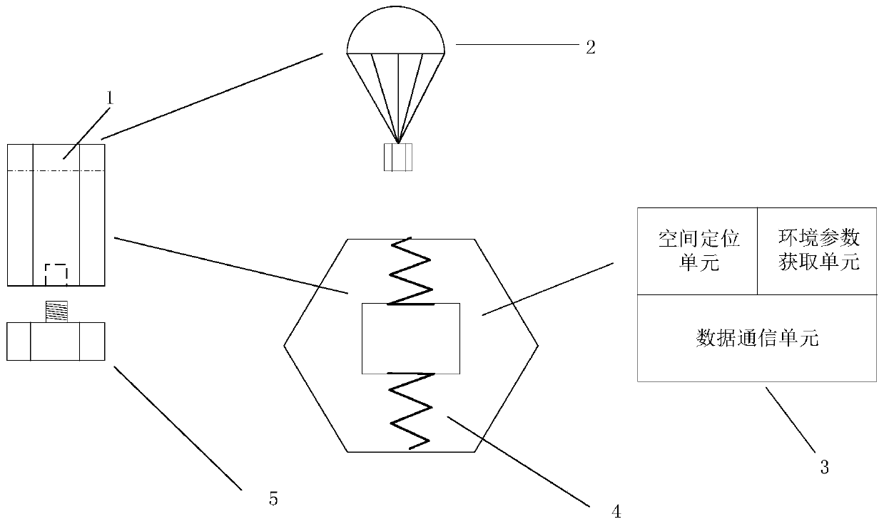
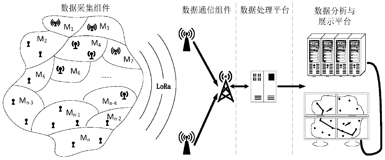
[0046] Such as figure 1 As shown, a large-scale fire situation analysis system based on spatial positioning includes data acquisition components, data communication components, data processing platforms, data analysis and display platforms. There are multiple data acquisition components, which are placed in areas that may be affected by fires. In each sub-area divided in , each data acquisition component is connected to the data communication component by wireless communication, the data communication component is connected to the data processing platfo...


PUM


Abstract

The invention discloses a large-scale fire situation analysis system based on spatial positioning. The system comprises data acquisition assemblies, a data communication assembly, a data processing platform, and a data analysis and display platform. The data acquisition assemblies are capable of carrying out spatial positioning and acquiring ambient environment parameters. The data acquisition assemblies collect ambient environment parameters and send the collected data and position information externally regularly by a wireless transmitting module. The data communication assembly receives data sent by the data acquisition assemblies, filters the data, and forwards the filtered data to the data processing platform. The data processing platform receives the data sent by the data communication assembly and processes the data to obtain situation information being able to reflect the fire situation. The data analysis and display platform is used for displaying the processed fire situationdata in real time and carrying out fire situation analysis and evaluation based on the fire situation. Therefore, the development trend of the fire can be sensed in real time and the fire situation isdisplayed at the data analysis and display platform, so that the disaster level is evaluated.

Description

technical field [0001] The invention relates to the field of fire spatial positioning systems, in particular to a large-scale fire situation analysis system based on spatial positioning. Background technique [0002] Fire, as a disaster, refers to a catastrophic burning phenomenon in which the fire source spreads out of control and causes losses to people's lives and property. Among various disasters, fire is one of the main disasters that most frequently and commonly threaten public safety and social development. Fire can burn away the material wealth created by human beings through hard work, and turn factories, warehouses, towns, villages and a large number of production and living materials into ashes, which affects the development of social economy and people's normal life to a certain extent. The fire also pollutes the atmosphere and destroys the ecological environment. The fire not only puts some people in trouble, but also kills many people, taking away many people...

Claims


Application Information

Patent Timeline
Patent Type & Authority Applications(China)
IPC IPC(8): G08B17/00H04L29/08H04W4/38
CPCG08B17/005H04W4/38H04L65/40
Inventor 曹力李琳王宇昆徐源廷刘晓平
Owner HEFEI UNIV OF TECH
Why Eureka
Try Eureka