Method and system for generating 3D point cloud map based on one-line lidar

A technology of laser radar and three-dimensional point cloud, which is applied in the direction of radio wave measurement system, electromagnetic wave re-radiation, instruments, etc., can solve the problems of time discount for drawing maps, very high motor precision requirements, and raise the threshold of technology, etc.

Active Publication Date: 2021-02-02
北京云迹科技股份有限公司
View PDF5 Cites 0 Cited by
  • Summary
  • Abstract
  • Description
  • Claims
  • Application Information

AI Technical Summary

Problems solved by technology

[0003] However, if a robot equipped with multi-line lidar is to be deployed in the same scene with a robot equipped with only one-line lidar at the same time, there will be the following problems: First, because the point cloud data obtained by its sensor is three-dimensional, resulting in expensive The sensor cannot give full play to its value and role in the two-dimensional map; in addition, there is currently no effective algorithm that can fuse the data of multi-line lidar and one-line lidar to uniformly draw a map that meets the positioning requirements. The two maps independently established by the two lidar algorithms cannot be well registered together
However, the map created by this technology cannot be used by indoor robots equipped with only one-line lidar, that is, this technology cannot directly generate a two-dimensional grid map
In addition, this technology requires very high motor precision, so the technical threshold is raised
Finally, the algorithm used in this technology has high requirements on the performance of the computer, which greatly reduces the time it takes to draw the map

Method used


Image

  • Method and system for generating 3D point cloud map based on one-line lidar
  • Method and system for generating 3D point cloud map based on one-line lidar
  • Method and system for generating 3D point cloud map based on one-line lidar

Examples


Embodiment Construction

[0041] The following will clearly and completely describe the technical solutions in the embodiments of the present invention with reference to the drawings in the embodiments of the present invention.

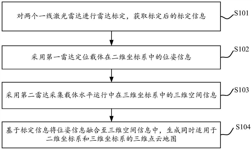
[0042] The 3D point cloud map generation method based on the one-line lidar provided by the embodiment of the present invention can be applied to the application scenario of generating a map for the navigation and positioning of a robot equipped with different sensors, taking into account the price cost and technical cost.

[0043] It should be noted that the terms "comprising" and "having" in the specification and claims of the present application and the above-mentioned drawings, as well as any variations thereof, are intended to cover non-exclusive inclusion, for example, including a series of steps or units A process, method, system, product or device is not necessarily limited to those steps or elements explicitly listed, but may include other steps or elements not explici...


PUM


Abstract

Embodiments of the present invention disclose a method and system for generating a three-dimensional point cloud map based on a one-line laser radar, wherein the method includes the following steps: performing radar calibration on two one-line laser radars, and obtaining calibrated calibration information, wherein the two one-line laser radars are The radars are a first radar installed horizontally and a second radar installed vertically. The first radar is used to locate the position and attitude information of the carrier in the two-dimensional coordinate system, and the second radar is used to collect the three-dimensional coordinates of the carrier in the three-dimensional coordinate system during horizontal operation. Spatial information, based on the calibration information, the pose information is fused into the three-dimensional spatial information, and a three-dimensional point cloud map suitable for both the two-dimensional coordinate system and the three-dimensional coordinate system is generated. The invention can generate a three-dimensional point cloud map while drawing a two-dimensional grid map, and can ensure that the two maps are in a unified coordinate system, so that robots equipped with different laser radars in the same scene can be unified in the same scene. Navigation location on the map.

Description

technical field [0001] The present invention relates to the technical field of map construction, in particular to a method and system for generating a three-dimensional point cloud map based on one-line laser radar. Background technique [0002] The navigation and positioning map is one of the foundations and key points for the normal operation of indoor robots. Due to cost issues, the current mainstream indoor robots are not equipped with multi-line lidar, but use one-line lidar to draw maps and navigate. Since the first-line lidar has only one beam of scanning measurement data, the map drawn by the sensor is limited to two-dimensional space, that is, there is only one plane. [0003] However, if a robot equipped with multi-line lidar is to be deployed in the same scene with a robot equipped with only one-line lidar at the same time, there will be the following problems: First, because the point cloud data obtained by its sensor is three-dimensional, resulting in expensive...

Claims


Application Information

Patent Timeline
Patent Type & Authority Patents(China)
IPC IPC(8): G01S17/89G01C21/20
CPCG01C21/206G01S17/89
Inventor 李全印安吉斯
Owner 北京云迹科技股份有限公司
Why Eureka
Try Eureka