Power transmission line forest fire monitoring method and device based on high-orbit and low-orbit satellite data

A technology of transmission lines and low-orbit satellites, which is applied in the direction of measuring devices, satellite radio beacon positioning systems, radio wave measurement systems, etc., to improve accuracy and timeliness, accurately monitor wildfires, and meet the requirements of time and space resolution required effect

Active Publication Date: 2019-10-15
YUNNAN POWER GRID CO LTD ELECTRIC POWER RES INST
View PDF6 Cites 4 Cited by
  • Summary
  • Abstract
  • Description
  • Claims
  • Application Information

AI Technical Summary

Problems solved by technology

[0006] This application provides a transmission line mountain fire monitoring method and device based on high-orbit and low

Method used


Image

  • Power transmission line forest fire monitoring method and device based on high-orbit and low-orbit satellite data
  • Power transmission line forest fire monitoring method and device based on high-orbit and low-orbit satellite data

Examples


Embodiment Construction

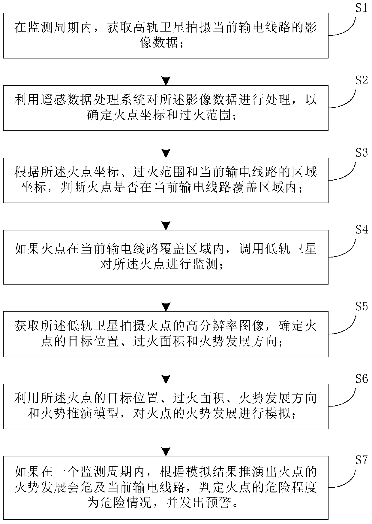
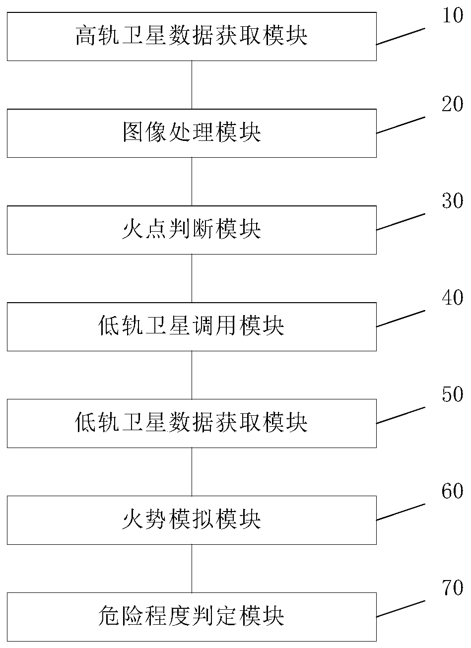
[0041] figure 1 It is a flowchart of a method for monitoring mountain fires on power transmission lines based on high-orbit and low-orbit satellite data provided by an embodiment of the present invention.

[0042] The embodiment of the present invention provides a transmission line mountain fire monitoring method based on high-orbit and low-orbit satellite data. Based on satellite remote sensing mountain fire monitoring and early warning, it can be used for forest fire prevention, fires around power transmission corridors, and oil pipelines. early warning. Specifically, according to the comprehensive analysis and comparison of high-orbit satellites and low-orbit satellites in terms of technical characteristics, business capabilities, and development trends, the two are used in combination to overcome or reduce the time when the same orbit satellites are used alone for monitoring. disadvantage. When locating the actual needs of users, combined with the advantages of large obs...


PUM


Abstract

The invention discloses a power transmission line forest fire monitoring method and device based on high-orbit and low-orbit satellite data. The method comprises the following steps of determining coordinates and the fire range of a fire point according to image data shot by a high-orbit satellite in a monitoring period; when the fire point is in the coverage area of a current power transmission line, calling a low-orbit satellite to monitor the fire point, and determining a target position, the fire area and a fire development direction of the fire point; and when the fire development of thefire point is deduced to endanger the current power transmission line by utilizing a simulation result of a fire deduction model, judging the danger level of the fire point as a dangerous situation, and giving out early warning. Therefore, the method and the device provided by the invention have the advantages that the time resolution of the high-orbit satellite and the spatial resolution of the low-orbit satellite are considered, so that fire monitoring and early warning of the power transmission line can be realized through fusion of the high-orbit satellite data and the low-orbit satellitedata, the requirements for the time resolution and the spatial resolution of fire monitoring of the power transmission line can be met at the same time, and forest fire monitoring can be carried out timely and accurately.

Description

technical field [0001] The present application relates to the technical field of status monitoring of power transmission equipment, in particular to a method and device for monitoring mountain fires in power transmission lines based on high-orbit and low-orbit satellite data. Background technique [0002] Forest fire is a major natural disaster in the ecological environment. There are hundreds of thousands of forest fires in the world every year, which brings serious harm to the forest ecosystem and human beings. In order to reduce the loss of forest fires, countries around the world attach great importance to forest fire monitoring. and early warning. At present, satellite remote sensing is an important method for forest fire monitoring. Satellite remote sensing technology is used to monitor the occurrence and dynamic changes of forest fires, and carry out accurate early warning and fire fighting. [0003] Satellites can be divided into sun-synchronous orbit satellites (lo...

Claims


Application Information

Patent Timeline
IPC IPC(8): G01S19/01G01S19/42G01N21/84
CPCG01S19/01G01S19/42G01N21/84Y02A40/28
Inventor 黄然周仿荣马仪沈志方明聂鼎金晶黄双得
Owner YUNNAN POWER GRID CO LTD ELECTRIC POWER RES INST
Why Eureka
Try Eureka