Road center line and double-line extraction method based on convolutional neural network regression

A convolutional neural network and extraction method technology, which is applied in the field of automatic extraction of remote sensing image information, can solve the problems of lack of road network topology information, neglect of connectivity, and impact on road accuracy in segmentation results, and achieve good generalization ability and generalization ability. Strong, geometrically accurate effects

Active Publication Date: 2019-10-18
CHONGQING GEOMATICS & REMOTE SENSING CENT +1
View PDF11 Cites 5 Cited by
  • Summary
  • Abstract
  • Description
  • Claims
  • Application Information

AI Technical Summary

Problems solved by technology

However, this strategy has several disadvantages: (1) a large number of burrs are likely to be generated near the road centerline and sidelines, which greatly affects the accuracy of road extrac

Method used


Image

  • Road center line and double-line extraction method based on convolutional neural network regression
  • Road center line and double-line extraction method based on convolutional neural network regression
  • Road center line and double-line extraction method based on convolutional neural network regression

Examples


Example Embodiment

[0046] The specific embodiments and working principles of the present invention will be described in further detail below with reference to the accompanying drawings.

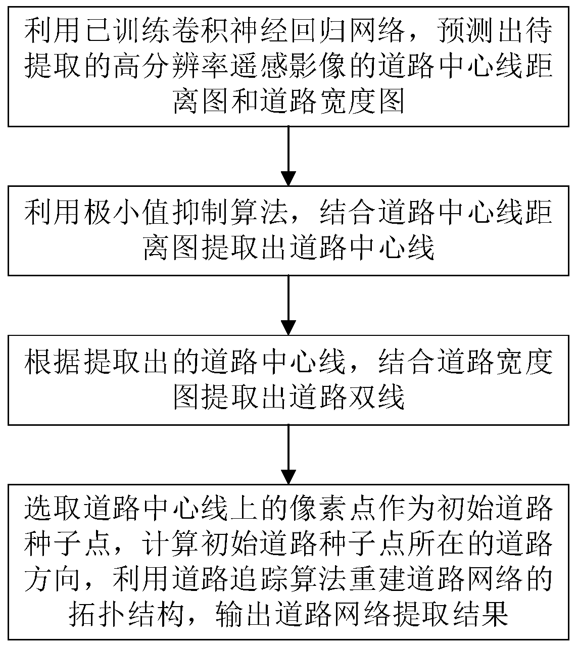
[0047] Such as figure 1 As shown, a road centerline and double-line extraction method based on convolutional neural network regression, the specific steps are as follows:
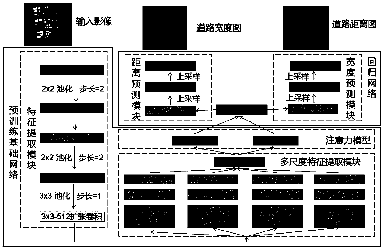
[0048] Step 1: Using the trained convolutional neural network, using multi-scale high-order semantic features and underlying features, to predict the distance between each pixel in the high-resolution remote sensing image to be extracted and the center line of the road and the road where the road pixel is located Width, predict the road centerline distance map and road width map of the high-resolution remote sensing image to be extracted;

[0049] Regarding the training process of the trained convolutional neural network:

[0050] Step A1: First, build a convolutional neural network to be trained. The entire network structure is as follows figure ...


PUM


Abstract

The invention discloses a road center line and double-line extraction method based on convolutional neural network regression, and the method comprises the following steps: predicting a road center line distance map and a road width map of a to-be-extracted high-resolution remote sensing image through employing a trained convolutional neural network; extracting a road center line by using a non-minimum suppression algorithm in combination with the road center line distance map; according to the extracted road center line, extracting road double lines in combination with a road width map; and selecting pixel points on the road center line as initial road seed points, calculating the road direction of the initial road seed points, reconstructing the topological structure of the road networkby using a road tracking algorithm, and outputting a road network extraction result. According to the method, through end-to-end training, the features easy to classify are directly learned from the training data, no post-processing is needed to extract the road centerline and sideline, the generalization ability is stronger, the road extraction precision is high, and the fine road extraction effect is better.

Description

technical field [0001] The invention relates to the technical field of automatic extraction of remote sensing image information, in particular to a method for extracting road centerlines and double lines based on convolutional neural network regression. Background technique [0002] Road extraction from high-resolution remote sensing images is an important task in the field of remote sensing. It has a wide range of applications in many fields, such as automatic driving, vehicle navigation, urban planning, digital line drawing, etc. Therefore, road extraction has important research value. [0003] Although many methods have been proposed in recent years. Road extraction is always a challenging task. This is due to the huge difference in road shape, color and context information in different scenes. In addition, the proportion of roads in remote sensing images is small, and the road width only occupies a few pixels, which is very easy to be blocked by trees, cars and shado...

Claims


Application Information

Patent Timeline
IPC IPC(8): G06K9/00G06K9/62
CPCG06V20/182G06F18/214
Inventor 丁忆李朋龙胡翔云曾安明张泽烈胡艳徐永书魏域君李晓龙张觅罗鼎陈静郑中刘朝晖王亚林范文武王小攀连蓉林熙谭攀
Owner CHONGQING GEOMATICS & REMOTE SENSING CENT
Why Eureka
Try Eureka