
A method for detecting changes in land cover types based on time series polsar images

A time-series, land-cover technology, applied in instrumentation, calculation, character and pattern recognition, etc., can solve the problems of difficulty in making full use of the time dimension information of time-series images and a large number of each image, so as to reduce costs and improve efficiency.

Active Publication Date: 2020-11-17
WUHAN UNIV
View PDF7 Cites 0 Cited by
  • Summary
  • Abstract
  • Description
  • Claims
  • Application Information

AI Technical Summary

Problems solved by technology

[0004] The purpose of the present invention is to solve the problems that the land cover supervision change detection method based on time series PolSAR images is difficult to make full use of the time dimension information between time series images, and usually requires a large number of high-quality training samples for each image.

Method used


Image

  • A method for detecting changes in land cover types based on time series polsar images
  • A method for detecting changes in land cover types based on time series polsar images
  • A method for detecting changes in land cover types based on time series polsar images

Examples


Embodiment Construction

[0043] The technical solution of the present invention will be described in detail below in conjunction with the drawings and embodiments.

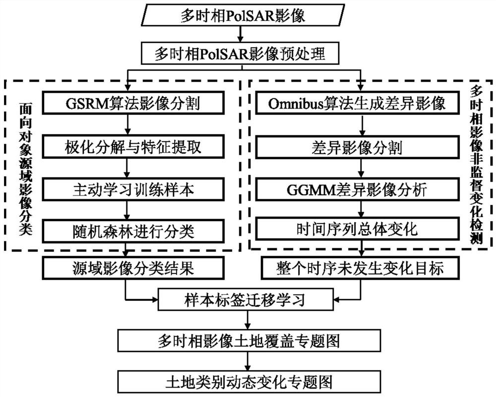
[0044] The technical scheme of the present invention can adopt computer technology to realize automatic operation, such asfigure 1 As shown, the process of the embodiment of the present invention includes the following steps:

[0045] Step 1: Time series PolSAR image preprocessing.

[0046] Before the detection of changes in land cover supervision, the present invention needs to preprocess the time series PolSAR images, use PolSARpro software and NEST software to perform radiation correction and geometric correction on the time series PolSAR images; select 7×7 Lee Sigma filter to suppress coherent speckle noise The impact on the change detection results; using ENVI software to register the time series PolSAR images.

[0047] Step 2: Classify the reference image using an object-oriented supervised classification method based on active lea...


PUM


Abstract

The present invention provides a land cover type change detection method based on time series PolSAR images. The purpose is to solve the problem that the current change detection method is difficult to make full use of the time dimension information between time series images, and usually requires a large number of high-quality training for each image. sample etc. The invention uses the Omnibus hypothesis test likelihood ratio algorithm to fully mine the time dimension information of the historically accumulated time series PolSAR images, and combines the marked category labels, classification thematic maps and other rich prior knowledge, and uses active learning and associated knowledge transfer learning And other machine learning algorithms to automatically label the category labels of each scene image, obtain reliable training samples, and then realize high-precision extraction of dynamic change information of land cover categories.

Description

technical field [0001] The invention belongs to the field of polarimetric synthetic aperture radar image interpretation, and is a new method for dynamically changing land cover types by using time-series polarimetric SAR (Polarimetric Synthetic Aperture Radar, PolSAR) images. Background technique [0002] With the continuous and rapid development of the global economy and the transformation of the natural environment by humans, the types of surface land cover are changing frequently. Among them, land cover change detection based on remote sensing images is an important means to study regional and even global land cover type changes. Because optical remote sensing images have the advantages of wide coverage, short revisit period, and easy image acquisition, land cover change detection methods based on remote sensing images have been widely used in various fields. However, optical remote sensing sensors are easily affected by factors such as weather and light, which greatly l...

Claims


Application Information

Patent Timeline
Patent Type & Authority Patents(China)
IPC IPC(8): G06K9/62
CPCG06F18/211G06F18/22G06F18/24323G06F18/214
Inventor 杨杰刘文宋李平湘赵金奇时洪涛
Owner WUHAN UNIV
Learn More