Vector grid model-based remote sensing image information extraction method and system

A remote sensing image and information extraction technology, applied in the field of remote sensing, can solve the problem of weak interactive editing ability of raster, and achieve the effect of saving time-consuming conversion.

Pending Publication Date: 2019-11-19
BEIJING GEOWAY INFORMATION TECH
View PDF9 Cites 4 Cited by
  • Summary
  • Abstract
  • Description
  • Claims
  • Application Information

AI Technical Summary

Problems solved by technology

[0005] Aiming at the above-mentioned technical problems in the related art, the present invention proposes a method and system for extracting remote sensing image information based on a vector raster model, which can not only avoid

Method used


Image

  • Vector grid model-based remote sensing image information extraction method and system
  • Vector grid model-based remote sensing image information extraction method and system
  • Vector grid model-based remote sensing image information extraction method and system

Examples


Embodiment Construction

[0056] The following will clearly and completely describe the technical solutions in the embodiments of the present invention with reference to the accompanying drawings in the embodiments of the present invention. Obviously, the described embodiments are only some, not all, embodiments of the present invention. All other embodiments obtained by persons of ordinary skill in the art based on the embodiments of the present invention belong to the protection scope of the present invention.

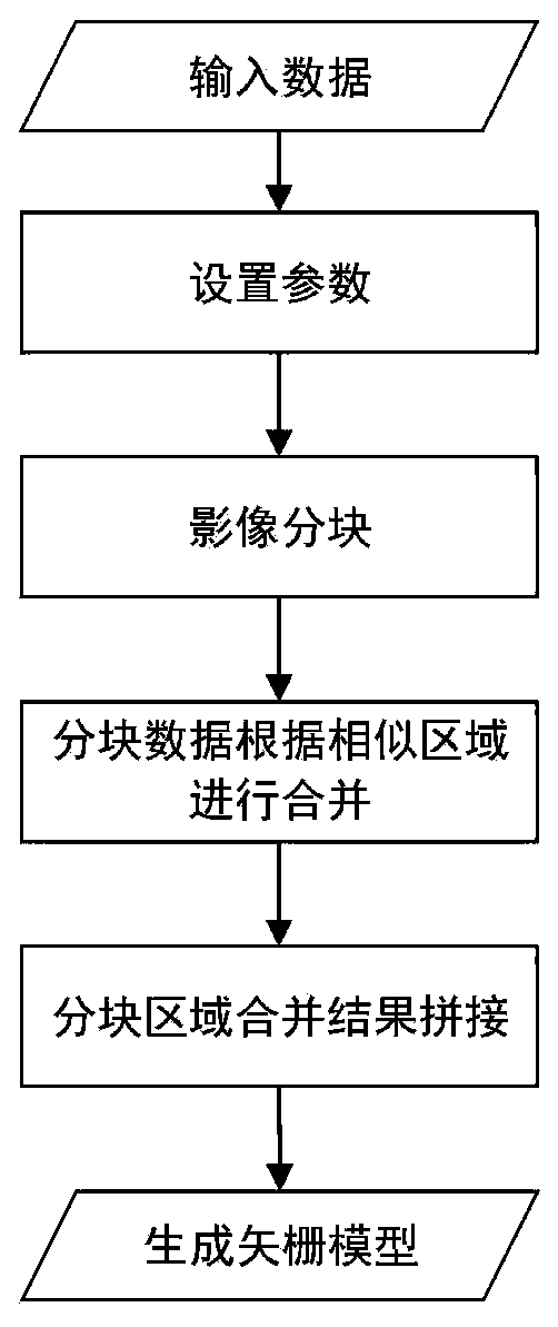
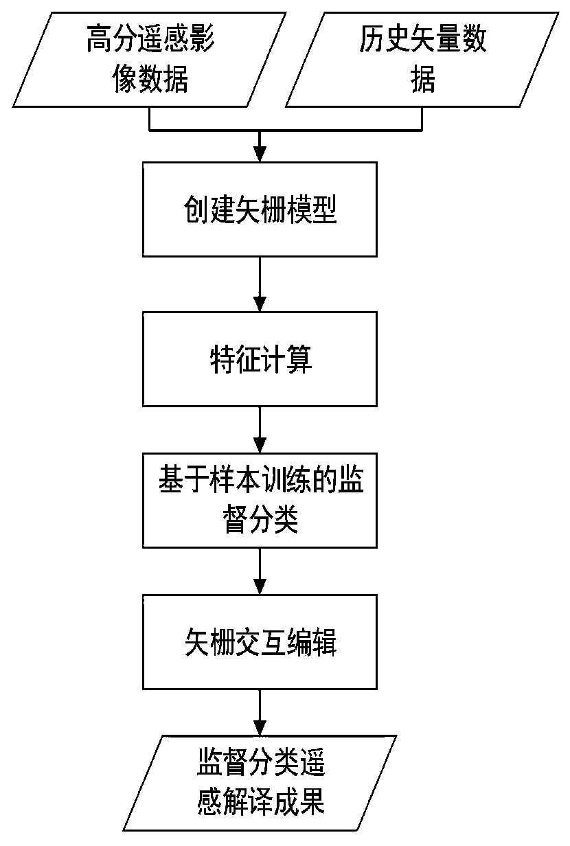
[0057] Such as image 3 and Figure 5 As shown, according to the vector raster model-based remote sensing image information extraction method described in the embodiment of the present invention, comprises the following steps:

[0058] Build a vector raster model;

[0059] Specifically, there are two situations for creating a vector raster model: 1) Take raster data as input, merge adjacent similar areas into patch objects, record the index relationship of each adjacent area merge, and gene...


PUM


Abstract

The invention discloses a vector grid model-based remote sensing image information extraction method and a vector grid model-based remote sensing image information extraction system. The method comprises the following steps of constructing a vector grid model; performing feature calculation on each object in the vector grid model; training samples are collected, and supervised classification is performed on the calculated feature dimensions; calculating the difference value of the segmented pattern spots of the front and rear images in the feature dimension, judging the pattern spot with the large difference value as a suspected change area, and extracting change discovery information through vector grid interactive editing. The method has the beneficial effects that vector grid model information is browsed and checked in real time; updating the neighborhood topology index file in real time to realize automatic construction of a topology relationship; the method is applied to high-spatial-resolution remote sensing image remote sensing information interpretation and remote sensing image change information extraction, and the application requirements of different high-resolution remote sensing data source information extraction are met.

Description

technical field [0001] The invention relates to the technical field of remote sensing, in particular to a method and system for extracting remote sensing image information based on a vector raster model. Background technique [0002] With the continuous launch of remote sensing satellites, remote sensing images and historical land cover data are increasing day by day. Interactive editing is inevitable in the post-processing of remote sensing image information. The traditional GIS platform cannot meet the strong interaction requirements of information extraction and post-processing, and it is difficult to support large volumes. The raster data volume of . [0003] Compared with traditional low-resolution remote sensing images, high-spatial-resolution remote sensing images have fewer spectral features and richer spatial texture and geometric information. However, the traditional method of extracting high-resolution remote sensing information using pixels as the analysis unit c...

Claims


Application Information

Patent Timeline
IPC IPC(8): G06T7/11G06T7/187G06T7/40G06T7/62G06K9/62
CPCG06T7/11G06T7/40G06T7/62G06T7/187G06F18/2411G06F18/214
Inventor 黎珂孙志伟宋海伟运晓东李咏洁戴海伦
Owner BEIJING GEOWAY INFORMATION TECH
Why Eureka
Try Eureka