
Field positioning surveying and mapping support

A technology of positioning sleeves in the field, applied in the field of surveying and mapping, can solve the problems of inconvenience, multiple adjustments can only be guaranteed, etc., to achieve the effect of ensuring the support effect, convenient height adjustment work, and rapid surveying and mapping work

Inactive Publication Date: 2020-01-24
青海崇霖测绘科技有限公司
View PDF8 Cites 9 Cited by
  • Summary
  • Abstract
  • Description
  • Claims
  • Application Information

AI Technical Summary

Problems solved by technology

[0003] Chinese patent announcement number CN209445016U is a kind of triangular support for surveying and mapping engineering, and CN208935739U is a kind of surveying and mapping instrument support for surveying and mapping. Similar to the existing technology, a tripod structure is used to support the surveying and mapping device. The stability of the triangular structure can ensure the accuracy of surveying and mapping. , to ensure the safety of the equipment, but when fixing, it is necessary to pre-adjust the angle of the triangular bracket before it can be installed stably. In the field, it is often not like the smooth road in the city. It is very inconvenient to ensure the required measurement angle and height only after one adjustment.

Method used


Image

  • Field positioning surveying and mapping support
  • Field positioning surveying and mapping support
  • Field positioning surveying and mapping support

Examples


Embodiment 1

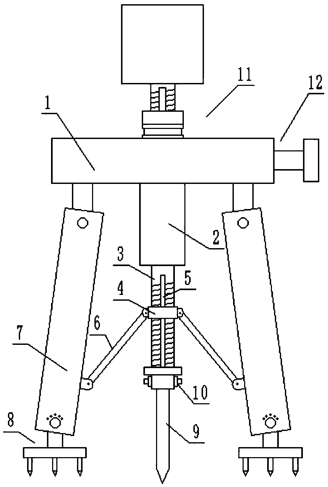
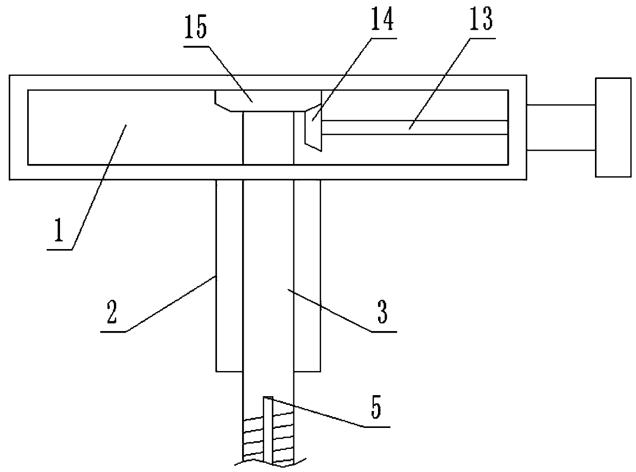
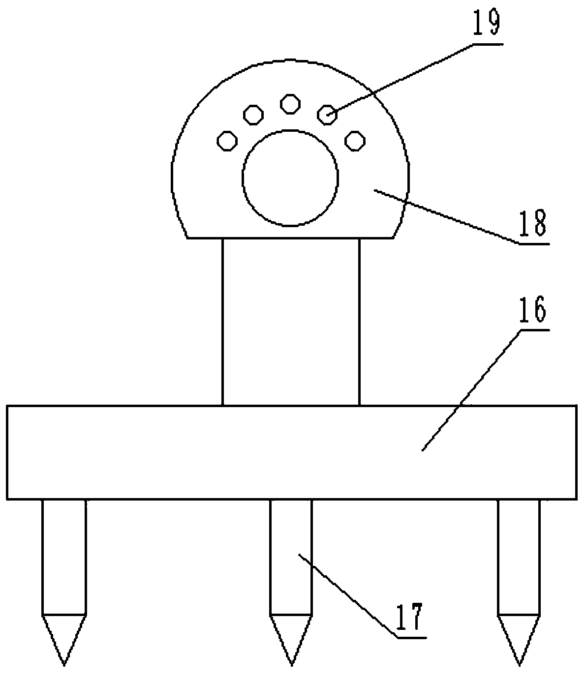
[0020] see Figure 1-4 , a field positioning surveying and mapping bracket, including a mounting frame body 1 and a surveying and mapping device 11, the surveying and mapping device 11 is fixed on the center of the top surface of the mounting frame body 1, and three supporting legs 7 distributed at equal intervals along the circumferential direction are arranged on the bottom surface of the mounting frame body 1 In the center of the bottom surface of the mounting bracket body 1, there is a central axis hollow rod 2 fixedly connected with it, and a positioning rod 9 is provided at the bottom of the central axis hollow rod 2. When fixing the whole device, first insert the positioning rod 9 at the designated position , and then adjust the support leg 7, which greatly facilitates the adjustment work. Specifically, the hollow rod 2 of the central axis is inserted with a main threaded rod 3 connected to it in rotation, and the lower half of the main thread has an external thread, th...

Embodiment 2

[0024] refer to Figure 5 , on the basis of Embodiment 1, in order to carry out the micro-adjustment work of the surveying and mapping device 11 after the positioning and fixing of the device is completed, the surveying and mapping device 11 includes an instrument body 20 and a connecting screw 21, and the connecting screw 21 is located in the positioning sleeve 22 and is slidingly connected with the positioning sleeve 22, the connecting screw rod 21 has an external thread, and an operating ring 23 is arranged below the positioning sleeve 22. The operating ring 23 is connected to the mounting bracket body 1 and the positioning sleeve 22 in rotation, and the operating ring 23 is connected to the connecting screw rod. 21 threaded rotation connection, and the side of the positioning sleeve 22 is provided with rods to be fixedly connected to the mounting frame body 1, and the two sides of the connecting screw 21 also have guide rods 5 slidingly connected with the positioning sleeve...


PUM


Abstract

The invention discloses a field positioning surveying and mapping support. The field positioning surveying and mapping support comprises a mounting frame body and a surveying and mapping device. The surveying and mapping device is fixed to the center of the top face of the mounting frame body, three supporting legs distributed in the circumferential direction at equal intervals are arranged on thebottom face of the mounting frame body, a center shaft hollow rod fixedly connected with the mounting frame body is arranged in the center of the bottom face of the mounting frame body, a positioningrod is arranged at the bottom of the center shaft hollow rod, and a main threaded rod rotationally connected with the center shaft hollow rod is inserted into the center shaft hollow rod. As the device is provided with the positioning rod and the supporting rods which are lifted and put down through lifting driver, when the device is overall fixed, firstly, the positioning rod is inserted into adesignated position, then the supporting legs are adjusted, thus, adjusting work is greatly facilitated, in this way, the supporting effect is guaranteed, height adjusting work at the earlier stage isfacilitated, a conventional single supporting leg adjusting manner is avoided, and surveying and mapping work can be rapidly carried out.

Description

technical field [0001] The invention relates to surveying and mapping technology, in particular to a field positioning surveying and mapping bracket. Background technique [0002] Surveying and mapping is surveying and drawing, which refers to the measurement, collection and drawing of the shape, size, spatial location and attributes of natural geographical elements or surface artificial facilities. Surveying and mapping instruments are instruments and devices designed and manufactured for data acquisition, processing, and output for surveying and mapping operations. The surveying and mapping instrument plays a key role in surveying and mapping operations, but the support of the surveying and mapping instrument generally uses multiple independent swinging poles as supporting components, and novice or practice surveying and mapping instruments often need to be calibrated. [0003] Chinese patent announcement number CN209445016U is a kind of triangular support for surveying a...

Claims


Application Information

Patent Timeline
Patent Type & Authority Applications(China)
IPC IPC(8): F16M11/28F16M11/04G01C15/00
CPCF16M11/04F16M11/28G01C15/00
Inventor 田忠星
Owner 青海崇霖测绘科技有限公司
Learn More