A method for extracting hidden geological structure information from remote sensing images

A technology of information extraction and geological structure, applied in the direction of instruments, scene recognition, measuring devices, etc., can solve the problems of low accuracy, high cost, and inability to interpret hidden geological structure information, and achieve the effect of saving manpower, material resources and time

Active Publication Date: 2022-06-03
INST OF MINERAL RESOURCES CHINESE ACAD OF GEOLOGICAL SCI
View PDF7 Cites 0 Cited by
  • Summary
  • Abstract
  • Description
  • Claims
  • Application Information

AI Technical Summary

Problems solved by technology
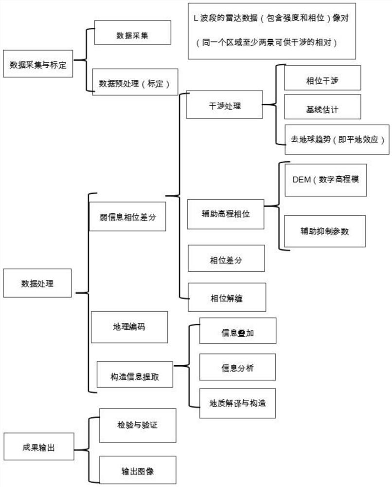
[0004] The purpose of the present invention is to provide a method for extracting hidden geological structure information from remote sensing images, so as to solve the problems of high cost, low accuracy and inability to interpret hidden geological structure information on the surface of the existing hidden geological structure information interpretation method

Method used


Image

  • A method for extracting hidden geological structure information from remote sensing images
  • A method for extracting hidden geological structure information from remote sensing images
  • A method for extracting hidden geological structure information from remote sensing images

Examples


Embodiment Construction

[0025] Below in conjunction with the accompanying drawings in the embodiments of the present invention, the technical solutions in the embodiments of the present invention will be clearly and completely

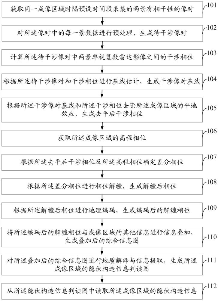
[0029] Step 101: Acquire coherent image pairs of two scenes collected in the same imaging area at a preset time interval.

[0030] Using the target area as an imaging area, collecting at least two initial image pairs for interference in the same imaging area,

[0032] Step 102: Preprocess each scene data in the image pair to generate an image pair to be interfered with.

[0034] Step 103: Calculate the interference phase between the two-view single-view complex radar images in the to-be-interfered image pair.

[0038] The interference phase φ includes the surface deformation information φ during the two imaging periods of the imaging region.

[0041] The estimation of the baseline is mainly to estimate the characteristics and quality of the interference image data through the anal...


PUM


Abstract

The invention discloses a method for extracting concealed geological structure information from remote sensing images. The method is mainly aimed at the remote sensing image data, adopts the method of enhancing the phase, and extracts the structural information by using the spatial features, so as to obtain the structural information of the concealed area. The method of the invention can accurately, quickly, economically and effectively interpret the structural information of the concealed area. Moreover, the method of the present invention is suitable for surface scanning interpretation, and can interpret concealed geological structure information on the regional surface. It has good application prospects in various aspects such as guiding mineral exploration, concealed target detection, hydrology, engineering, etc. In the process, it can save time, save manpower and material resources, and get twice the result with half the effort.

Description

A method for extracting hidden geological structure information from remote sensing images technical field The present invention relates to hidden geological structure information extraction technical field, particularly relate to a kind of remote sensing image hidden geological Construct the information extraction method. Background technique The structural information of the hidden area is at a certain depth underground, and the images obtained by remote sensing cannot be obtained due to the coverage of the surface. See, but due to the particularity of the structure, the deformation obtained by the structure has a certain difference between the structure site and the two sides of the structure. The radar phase difference has a certain difference, how to obtain and use this information effectively is one of the remote sensing image processing. important aspects. Tectonic information invisible to the naked eye is often hidden beneath the Quaternary-covered or desert...

Claims


Application Information

Patent Timeline
Patent Type & Authority Patents(China)
IPC IPC(8): G06V20/13G01S7/41G06V10/30
CPCG01S13/9023G01S7/41G06V20/13G06V10/30
Inventor 姚佛军耿新霞杨建民
Owner INST OF MINERAL RESOURCES CHINESE ACAD OF GEOLOGICAL SCI
Why Eureka
Try Eureka