Method for realizing construction progress monitoring based on unmanned aerial vehicle oblique photogrammetry technology

A technology for oblique photogrammetry and construction progress, which is applied in the field of construction progress monitoring based on UAV oblique photogrammetry technology. Model establishment and other issues, to achieve the effect of easy construction progress monitoring, easy control, and improved spatial form.

Active Publication Date: 2020-04-14
内蒙古蒙能建设工程监理有限责任公司
View PDF6 Cites 10 Cited by
  • Summary
  • Abstract
  • Description
  • Claims
  • Application Information

AI Technical Summary

Problems solved by technology

[0005] Although the above-mentioned patent documents use UAVs in the field of engineering progress monitoring, they do not use the data obtained by UAVs to establish a 3D real model, but directly compare with the planned construction progress, which cannot be seen intuitively and clearly. The difference between the actual construction progress and the planned construction progress is identified. The main purpose is to eliminate the need for on-site monitoring of the actual construction progress. However, the detection by drone photography still cannot realistically reflect the characteristics of the building changing with the construction progress in a three-dimensional form.

Method used


Image

  • Method for realizing construction progress monitoring based on unmanned aerial vehicle oblique photogrammetry technology
  • Method for realizing construction progress monitoring based on unmanned aerial vehicle oblique photogrammetry technology
  • Method for realizing construction progress monitoring based on unmanned aerial vehicle oblique photogrammetry technology

Examples


Embodiment Construction

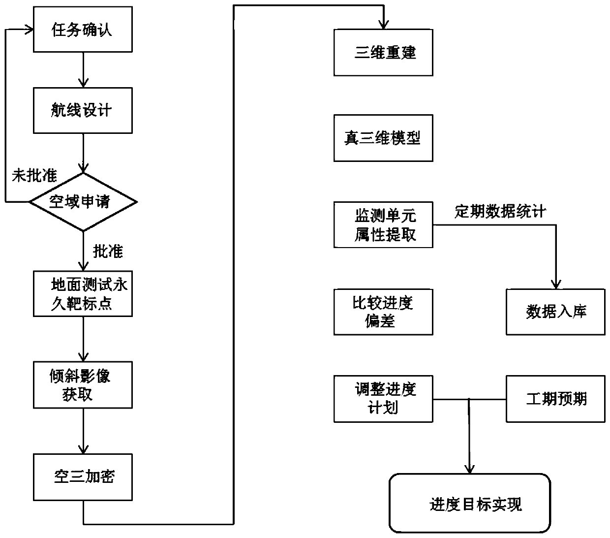
[0041] Attached below Figure 1-4 , the specific embodiment of the present invention is described in detail.

[0042] like figure 1 As shown, the present invention provides a method for monitoring construction progress based on unmanned aerial vehicle oblique photogrammetry technology, including the following steps:

[0043] S1: confirm the construction task;

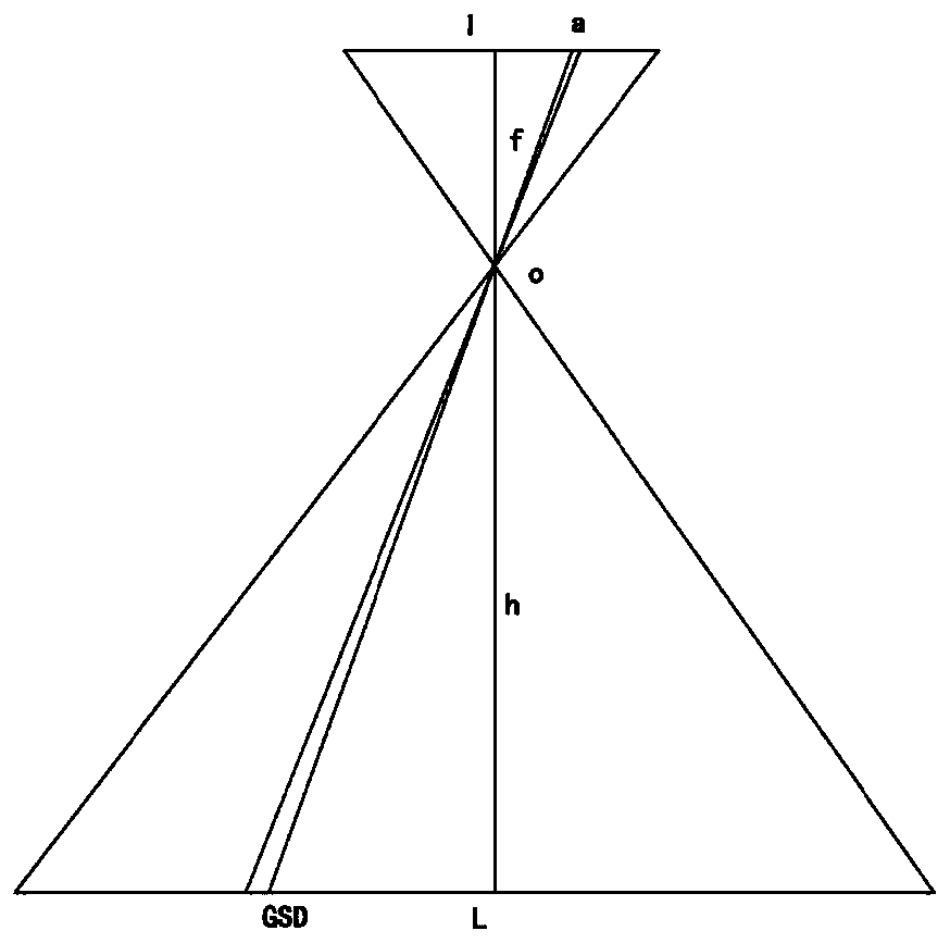
[0044] S2: Carry out route design according to the construction tasks in step S1; the route design includes flight height design, route layout and course coverage; flight height is designed according to the height of buildings in the factory area, ground resolution, and surrounding conditions; the route is designed according to the shooting area Arrange in a straight line to ensure that the first and last route shots parallel to the boundary line of the shooting area can obtain effective images of the measurement area; the heading coverage exceeds the boundary line of the shooting area by at least 3 baselines;

[004...


PUM


Abstract

The invention, which relates to the field of construction progress monitoring, provides a method for realizing construction progress monitoring based on an unmanned aerial vehicle oblique photogrammetry technology . The method comprises the following steps: S1, determining a construction task; S2, designing a route according to the construction task in the S1; S3, after completion of the airline design in the S2, determining whether the airspace application is approved or not; if not, returning to the S1; and if so, carrying out the S4; S4, arranging target points on the ground of a plant; S5,according to the arrangement of the target points in the S4, acquiring plant area images obliquely through an unmanned aerial vehicle; S6, carrying out aerial triangulation; S7, generating a true three-dimensional model; S8, after construction of the true three-dimensional model, comparing the actual construction progress witha planned construction progress to reflect progress deviation; and S9,predicting a later engineering progress trend. The method can vividly reflect the spatial form of a building and is easy to compare the construction progress deviation.

Description

technical field [0001] The invention relates to a method for monitoring construction progress, in particular to a method for monitoring construction progress based on unmanned aerial vehicle tilt photogrammetry technology. Background technique [0002] The construction of a power plant is generally divided into several stages such as "preliminary", "feasibility study", "start", "construction", and "commissioning". The most complicated management stage is the construction stage, where the construction progress is monitored, the progress deviation is discovered in time, the cause of the deviation and its impact on the follow-up work and the total construction period are analyzed, and corresponding measures are taken when necessary to ensure the realization of the progress goal. It is of great significance for construction progress monitoring. The current construction progress monitoring methods include: bar chart method, S-curve comparison method, banana curve comparison meth...

Claims


Application Information

Patent Timeline
Patent Type & Authority Applications(China)
IPC IPC(8): G01C11/26
CPCG01C11/26
Inventor 张健孙义君梁永生乔俊威高波王国强
Owner 内蒙古蒙能建设工程监理有限责任公司
Why Eureka
Try Eureka