Mapping system based on pseudo-gnss and ins

A map and coordinate system technology, applied in the field of cartography, can solve problems that are not suitable for various applications

Active Publication Date: 2022-03-29
WUHU HIT ROBOT TECH RES INST
View PDF12 Cites 0 Cited by
  • Summary
  • Abstract
  • Description
  • Claims
  • Application Information

AI Technical Summary

Problems solved by technology

Near-perfect performance is obtained with GNSS in open outdoor environments, but extending these MMSs to GNSS-limited areas such as indoor environments is very challenging, and the integration of GNSS / INS modules and map sensors amplifies the Pros and cons of INS units, the georeferenced maps generated are limited to areas where GNSS signals are always available, therefore, this MMS is not suitable for several applications in GNSS denied environments such as indoor surveying and underground navigation

Method used


Image

  • Mapping system based on pseudo-gnss and ins

Examples


Embodiment Construction

[0021] In order to make the object, technical solution and advantages of the present invention clearer, the present invention will be further described in detail below in conjunction with the accompanying drawings and embodiments. It should be understood that the specific embodiments described here are only used to explain the present invention, not to limit the present invention.

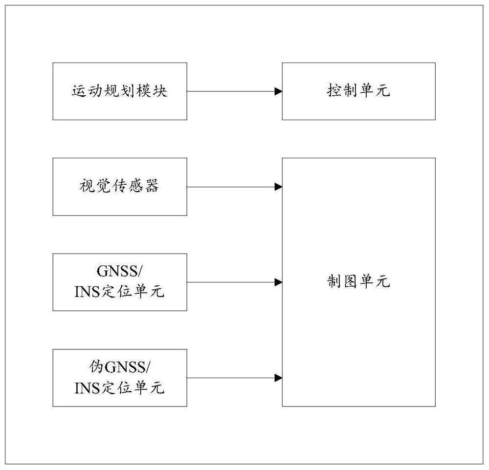
[0022] figure 1 The structural diagram of the mapping system based on pseudo-GNSS and INS provided for the embodiment of the present invention, for the convenience of description, only shows the part related to the embodiment of the present invention.

[0023] The system includes:

[0024] The motion planning module inputs the moving route of the mobile platform and sends the moving route to the control unit;

[0025] The visual sensor collects the environmental data of the driving area and extracts the road signs in the current frame of environmental data;

[0026] GNSS / INS positioning unit, in...


PUM


Abstract

The present invention is applicable to the technical field of mapping, and provides a mapping system based on pseudo-GNSS and INS, including: a motion planning module, which inputs the moving route of the mobile platform, and sends the moving route to the control unit; a visual sensor arranged on the mobile platform , collect the environmental data of the driving area, and extract the road signs in the current frame environmental data; the GNSS/INS positioning unit, in a GNSS-friendly environment, locates the current pose of the mobile platform, and sends the current pose of the mobile platform to the mapping unit; GNSS/INS positioning unit, in the GNSSS rejected environment, obtains the current pose of the mobile platform based on the constructed map, and sends the current pose of the mobile platform to the mapping unit; the mapping unit sends the current frame based on the current pose of the mobile platform The unknown landmarks in the map are incorporated into the map; the control unit controls the mobile platform to move according to the set mobile route; in the GNSS-denied environment, the pseudo-GNSS/INS positioning unit is used to realize the function of the actual GNSS/INS structure, so that the cartography system can be used in a GNSS-rich environment And GNSS denial environment can realize the mapping function.

Description

technical field [0001] The invention belongs to the field of mapping technology and provides a mapping system based on pseudo GNSS and INS. Background technique [0002] Mobile mapping systems (MMS) not only facilitate the comprehensive 3D mapping of different environments, but also pave the way for a new field of applied research in this direction. Among the many basic modules of MMS, localization and orientation modules are considered to be crucial and expensive components, and these modules combined with map sensors can provide high-quality maps. With the rapid development of science and technology, MMS technology and its supporting technology have made great progress, the most representative is the comprehensive integration of GNSS / INS positioning system and various map sensors applied to MMS technology. Near-perfect performance is obtained with GNSS in open outdoor environments, but extending these MMSs to GNSS-limited areas such as indoor environments is very challeng...

Claims


Application Information

Patent Timeline
Patent Type & Authority Patents(China)
IPC IPC(8): G01C21/00G01C21/16G01S19/45G01S19/47G09B29/00
CPCG01C21/165G01C21/005G01S19/45G01S19/47G09B29/005
Inventor 徐劲松高云峰曹雏清陈柱任鹏
Owner WUHU HIT ROBOT TECH RES INST
Why Eureka
Try Eureka