Supercharge Your Innovation With Domain-Expert AI Agents!

An automatic geometric correction method for remote sensing image data based on deep learning

A remote sensing image and deep learning technology, applied in image data processing, image enhancement, image analysis, etc., can solve the problem of low efficiency of manual remote sensing image geometric correction, and achieve the effect of reducing errors, improving accuracy and avoiding high costs.

Active Publication Date: 2022-04-29
WUHAN UNIV
View PDF12 Cites 0 Cited by
  • Summary
  • Abstract
  • Description
  • Claims
  • Application Information

AI Technical Summary

Problems solved by technology

[0006] The present invention realizes automatic geometric correction of remote sensing images by providing an automatic geometric correction method of remote sensing image data based on deep learning, and solves the problem of low efficiency of artificial remote sensing image geometric correction

Method used


Image

  • An automatic geometric correction method for remote sensing image data based on deep learning
  • An automatic geometric correction method for remote sensing image data based on deep learning
  • An automatic geometric correction method for remote sensing image data based on deep learning

Examples


Embodiment Construction

[0034] The technical solutions of the present invention will be further described below in conjunction with the accompanying drawings and embodiments.

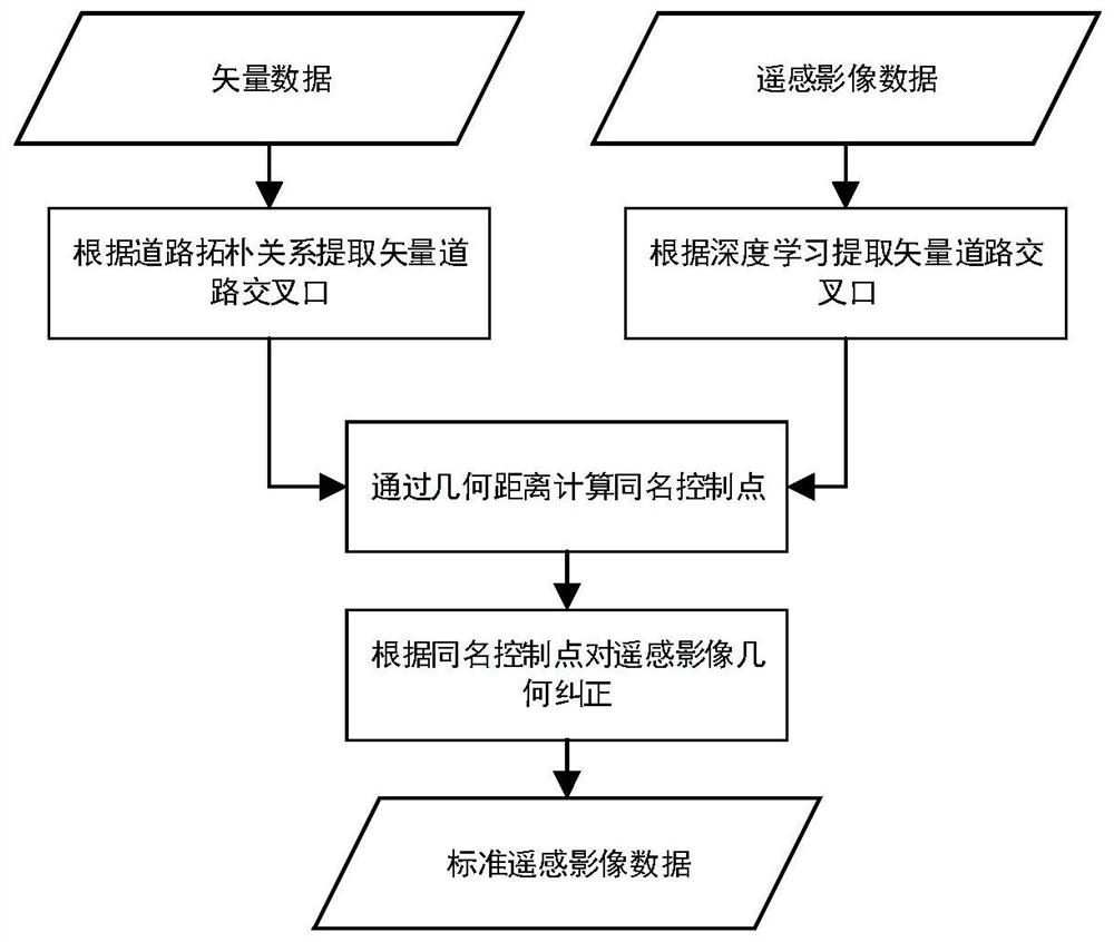
[0035] This embodiment provides a method for automatic geometric correction of remote sensing image data based on deep learning, which is suitable for automatic geometric correction of remote sensing image data, including the following steps:

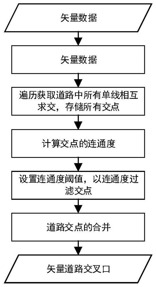
[0036] Step 1. According to the geometric topological relationship, select road intersections as control points from the vector road data. The selection process of vector road intersection control points is as follows:

[0037] Step 1: first traverse the road network data in the vector data to obtain and store all road single lines, and then obtain intersection points through pairwise intersection, and store all intersection points.

[0038] Step 2: Calculate the connectivity of road intersections. The connectivity of road intersections refers to the number of vector roads connected to ...


PUM


Abstract

The invention discloses an automatic geometric correction method for remote sensing image data based on deep learning, comprising: step 1, selecting road intersections as control points from vector road data according to the geometric topological relationship; step 2, using vector data road The intersection control point is the center, and the remote sensing image is intercepted with a certain area of ​​the window, and the image road intersection is extracted from the intercepted remote sensing image by using the trained deep learning model, and the control point of the same name is formed by matching the geometric distance with the vector data road intersection; Step 3: Use the density-based spatial clustering algorithm to clean the data of the control points with the same name, and use the cleaned control points with the same name to perform geometric correction on the remote sensing image based on the binary cubic polynomial correction model. In the present invention, a deep learning model is used to automatically extract road intersection control points from remote sensing images, which improves the accuracy of feature extraction from remote sensing images.

Description

technical field [0001] The invention relates to the technical field of geometric correction of remote sensing image data, in particular to an automatic geometric correction method of remote sensing image data based on deep learning. Background technique [0002] At present, the spatial resolution of multi-band remote sensing images has reached the meter level, and the spatial resolution of single-band images has reached sub-meters. Such high-resolution remote sensing images can clearly express the structure, texture and other detailed information of some ground features and landscapes, so that we can not only obtain rich spectral information of ground features, but also obtain more information about the structure, shape and texture of ground features. The information makes it possible to observe the detailed changes of the earth's surface on a small spatial scale, to carry out large-scale remote sensing mapping, and to monitor the impact of human activities on the environmen...

Claims


Application Information

Patent Timeline
Patent Type & Authority Patents(China)
IPC IPC(8): G06T5/00G06V10/762G06K9/62
CPCG06T5/006G06T2207/20081G06T2207/20084G06T2207/10032G06F18/23
Inventor 王艳东邵鑫刘波贺楷锴魏广泽李小雨
Owner WUHAN UNIV
Features
  • R&D
  • Intellectual Property
  • Life Sciences
  • Materials
  • Tech Scout
  • Unparalleled Data Quality
  • Higher Quality Content
  • 60% Fewer Hallucinations
Learn More