Method for obtaining real-time ground position of airport airplane

A technology for airplanes and airports, applied in the field of obtaining real-time ground positions of airports and airplanes based on deep learning technology for target detection, it can solve the problems of high cost and easy loss of positioning signals, and achieve strong professional applicability, highly specific scenarios, and data volume dependence low effect

Active Publication Date: 2020-05-29
上海麦图信息科技有限公司
View PDF5 Cites 6 Cited by
  • Summary
  • Abstract
  • Description
  • Claims
  • Application Information

AI Technical Summary

Problems solved by technology

ADS-B equipment may be manually turned off by the pilot, multi-point radar equipment and surface surveillance radar are expensive and are not deployed at many airports
At the same time, the above-mentioned equipment also has the problem that the positioning signal near the building is easily lost

Method used


Image

  • Method for obtaining real-time ground position of airport airplane
  • Method for obtaining real-time ground position of airport airplane
  • Method for obtaining real-time ground position of airport airplane

Examples


Embodiment approach

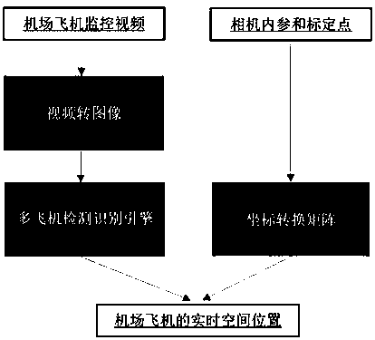
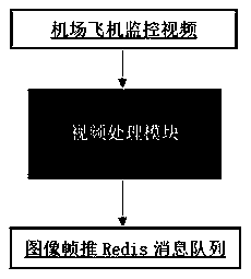
[0037] like figure 2 As shown, the airport aircraft monitoring data is in the form of video, which cannot be directly applied to the target detection model. It must first be converted into a picture and pushed to the Redis message queue, and the speed of at least 25 frames per second must be met. Its implementation is as follows:

[0038] pool = redis.ConnectionPool(host='...', port=6379)

[0039] red = redis.Redis(connection_pool=pool)

[0040] camera = cv2. VideoCapture()

[0041] while True:

[0042] input_bgr = camera. read()

[0043] msg = {'img':input_bgr}

[0044] msg_encode = cPickle. dumps(msg)

[0045] red.lpush("test1",msg_encode)

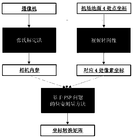
[0046] S2: Obtain the coordinate transformation matrix between the camera image and the airport calibration point; the acquisition process of the coordinate transformation matrix is ​​as follows image 3As shown, the specific method is: S2.1 Obtain the internal parameters and distortion coefficients of the camera: print a checke...


PUM


Abstract

The invention discloses a method for obtaining the real-time ground position of an airport airplane, and the method comprises the following steps: obtaining an airport airplane monitoring video, and converting the video into an image frame; obtaining a coordinate transformation matrix between the camera image and the airport calibration point; establishing a target detection depth network model; making training data and training a target detection deep network model to obtain a multi-aircraft detection recognition engine; and finally, calculating to obtain the real-time spatial position of theaircraft by using the recognition engine and the coordinate transformation matrix. According to the method, the target detection deep learning technology is used for detecting the airplanes in the airport runway monitoring video, the camera imaging principle is combined, the real-time position information of the airplanes in the airport can be automatically obtained, the method has the advantagesof being high in applicability, high in accuracy and low in cost, and guarantees are provided for control personnel to guide the airplanes and guarantee the safety of the airport runway.

Description

technical field [0001] The invention relates to the technical field of aircraft positioning, in particular to a method for obtaining real-time ground positions of aircraft at airports based on deep learning technology for target detection. Background technique [0002] With the expansion of domestic airports and the increase in the number of aircraft, it is easy for the aircraft to park in the wrong parking space during the taxiing process, which will result in no available parking space for the planned flight, and the control personnel cannot confirm the specific location location, which greatly reduces the efficiency of airport and maintenance work. [0003] At present, the aircraft positioning methods mainly include ADS-B positioning, multi-point radar positioning, and inter-field radar positioning. ADS-B equipment may be manually disabled by the pilot, and multipoint radar equipment and surface surveillance radar are expensive and are not deployed at many airports. At ...

Claims


Application Information

Patent Timeline
Patent Type & Authority Applications(China)
IPC IPC(8): G06T7/70G06T7/80
CPCG06T7/70G06T7/80G06T2207/10016G06T2207/20081G06T2207/20084
Inventor 孔维国李鑫
Owner 上海麦图信息科技有限公司
Why Eureka
Try Eureka