Contour line generation optimization method with geological direction characteristics

An optimization method and contouring technology, applied in the field of geological exploration and geological interpretation, can solve problems that do not conform to the change law of geological contours, and achieve the effect of improving the problem

Active Publication Date: 2020-06-05
CHINA PETROLEUM & CHEM CORP +1
View PDF4 Cites 2 Cited by
  • Summary
  • Abstract
  • Description
  • Claims
  • Application Information

AI Technical Summary

Problems solved by technology

[0004]Because the sampling point data is manually detected, if only a very small number of data points are sampled in a certain geographic location area, the drawn contour map will appear Several circular-like contours with this sampling point as the center of the circle do not conform to the changing law of geological contours

Method used


Image

  • Contour line generation optimization method with geological direction characteristics
  • Contour line generation optimization method with geological direction characteristics
  • Contour line generation optimization method with geological direction characteristics

Examples


Embodiment Construction

[0051] In order to make the above and other objects, features and advantages of the present invention more comprehensible, the preferred embodiments are listed below and shown in the accompanying drawings in detail as follows.

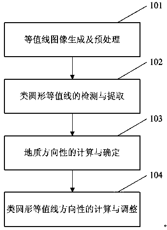
[0052] Such as figure 1 as shown, figure 1 Flowchart of the optimization method for contour generation with geological orientation features of the present invention.

[0053] Step 101: contour image generation and preprocessing; contour generation requires sampling point data or contour data, and contour data includes contour sequence data of geological contour maps and contour maps after contour mapping image data.

[0054] The line sequence data of the geological contour is the tracking data of each contour. It is the data on the grid line used to track specific contour values ​​calculated after the geological sampling point data is interpolated to form grid data.

[0055] The image data after the contour mapping is a contour map formed after the c...


PUM


Abstract

The invention provides a contour line generation optimization method with geological direction characteristics. The contour line generation optimization method with geological direction characteristics comprises the steps of 1, performing contour line image generation and preprocessing; 2, detecting and extracting a quasi-circular contour line; 3, determining the direction of a quasi-circular contour line by adopting a standard deviation ellipse method; 4, determining the adjustment degree and direction of the quasi-circular contour line by adopting the sizes and directions of the long axis and the short axis of the standard deviation ellipse calculated in the step 3. The contour line generation optimization method with the geological direction characteristics is applied to the field of geological exploration and the field of geological interpretation, and particularly plays an important role in the geological contour map drawing process.

Description

technical field [0001] The invention relates to the fields of geological exploration and geological interpretation, in particular to a method for generating and optimizing contours with geological direction characteristics. Background technique [0002] Contour map is a very important representation in geological interpretation system. According to a large amount of data obtained by scientific means, the underground geological structure and geological distribution parameters are inferred, and the plane geological contour map of the corresponding area is constructed, which can represent the geological form of the formation, oil layer, and gas layer, and the thickness of the formation. Determine the location, shape, and oil reserves of oil-rich areas. The research of isolines mainly focuses on the generation and drawing of isolines, and now a relatively complete set of theories and algorithms has been formed. [0003] However, the change trend of the contour line in the geol...

Claims


Application Information

Patent Timeline
Patent Type & Authority Applications(China)
IPC IPC(8): G06T5/00G06T7/13G06T7/62G06T7/66G06T11/20
CPCG06T11/206G06T7/13G06T5/002G06T7/66G06T7/62
Inventor 隋国华彭英陈林路慎强侯树杰吴明荣曲志鹏李玲祝洪慧
Owner CHINA PETROLEUM & CHEM CORP
Why Eureka
Try Eureka