Line patrol method, system and device for fixed-wing unmanned aerial vehicle in complex geographical environment

A geographical environment, fixed-wing technology, applied in image data processing, data processing applications, overhead line/cable equipment, etc. Long battery life, improved line inspection efficiency, and strong operability

Active Publication Date: 2020-06-05
GUANGDONG POWER GRID CO LTD +1
View PDF9 Cites 1 Cited by
  • Summary
  • Abstract
  • Description
  • Claims
  • Application Information

AI Technical Summary

Problems solved by technology

[0003] In inland areas, many power lines are located in remote mountainous areas with geographical loads such as high altitude, high cold, and high drop. If manual line inspection is used, it will not only consume a lot of financial and material resources, but also have low inspection efficiency. high risk
The existing technology usually uses multi-rotor UAVs for line inspection, but the range of line inspection is short and requires constant transitions, resulting in low efficiency and cannot meet the actual power line inspection needs
However, the manned helicopter inspection method has a higher cost, and it is not easy to operate the manned helicopter in a complex geographical environment, which has a strong risk

Method used


Image

  • Line patrol method, system and device for fixed-wing unmanned aerial vehicle in complex geographical environment
  • Line patrol method, system and device for fixed-wing unmanned aerial vehicle in complex geographical environment
  • Line patrol method, system and device for fixed-wing unmanned aerial vehicle in complex geographical environment

Examples


Embodiment 1

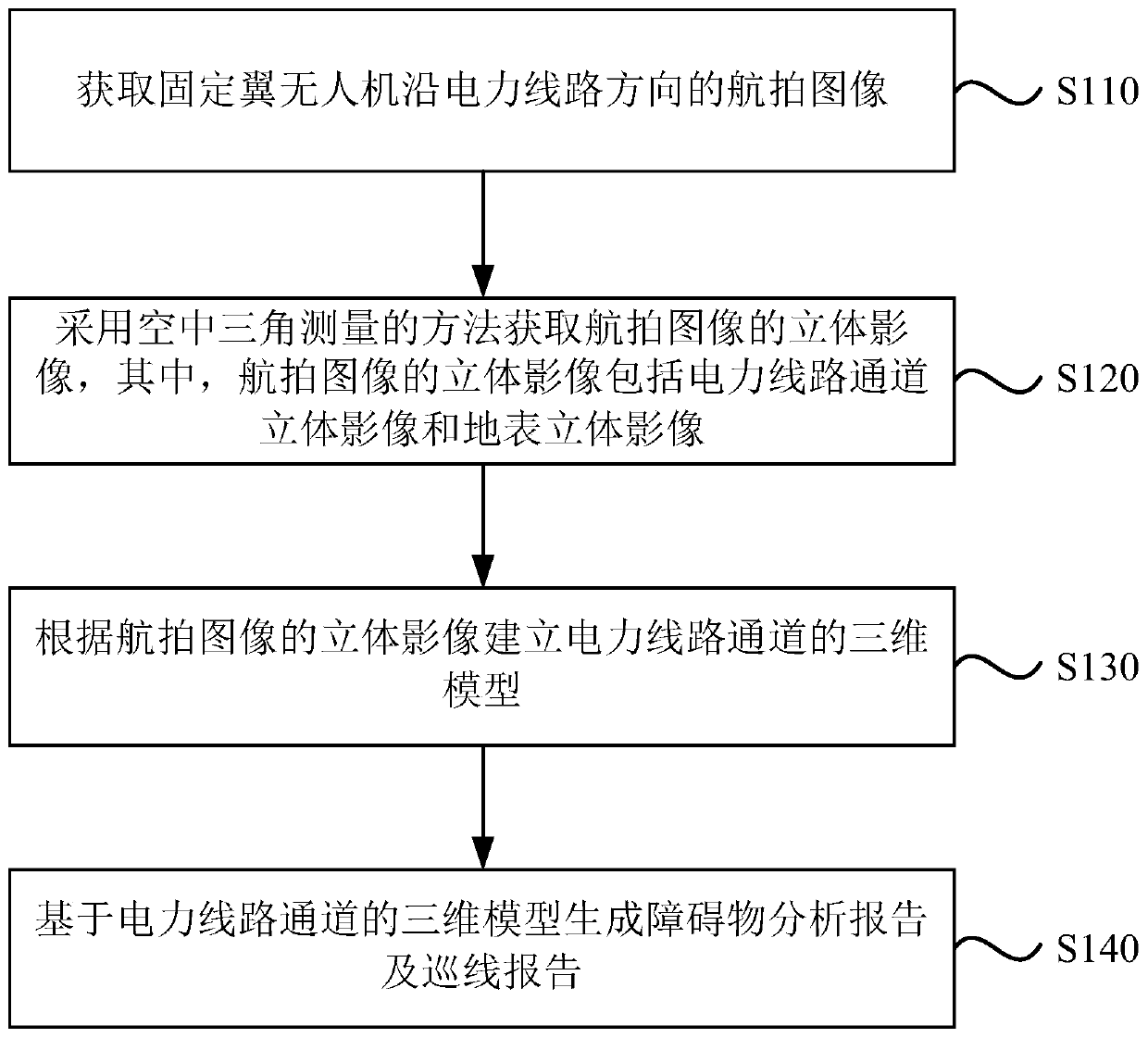
[0047] figure 1 It is a flow chart of a fixed-wing unmanned aerial vehicle line inspection method in a complex geographical environment provided by Embodiment 1 of the present invention. This embodiment can be applied to the situation where power lines in a complex geographical environment are inspected. The method can It is performed by a fixed-wing UAV line inspection system in a complex geographical environment, which specifically includes the following steps:

[0048] Step 110, acquiring aerial images of the fixed-wing UAV along the direction of the power line.

[0049] Specifically, due to its own performance, the fixed-wing UAV has the characteristics of long endurance and low cost, and vertical take-off and landing can be realized by controlling the aerodynamic part of the fixed-wing UAV. The fixed-wing UAV is equipped with a navigation system, which can automatically take aerial photography along the power line. The fixed-wing UAV is also equipped with an image trans...

Embodiment 2

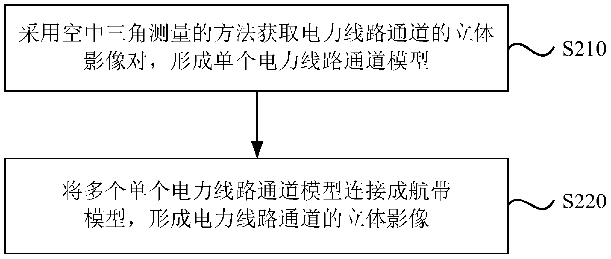
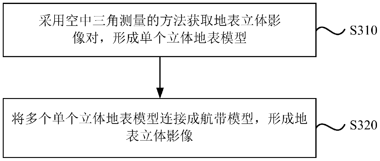
[0058] figure 2 It is a flowchart of a specific method for obtaining a stereoscopic image of an aerial image by using an aerial triangulation method provided by Embodiment 2 of the present invention. On the basis of the above-mentioned embodiment, the method provided by this embodiment obtains an aerial image by using an aerial triangulation method Stereoscopic images, wherein, the stereoscopic images of aerial images include power line channel stereoscopic images and surface stereoscopic images specifically include the following steps:

[0059] Step 210, adopting aerial triangulation method to acquire stereoscopic image pairs of power line channels to form a single power line channel model.

[0060] Specifically, a stereoscopic image pair refers to two aerial images shot from different angles for the same area, and has an overlapping area. Through the principle of stereoscopic vision, a stereoscopic image can be seen in the overlapping area. The overlapping area formed by e...

Embodiment 3

[0068] optional, Figure 4 It is a flow chart of a fixed-wing unmanned aerial vehicle line inspection method in a complex geographical environment provided by Embodiment 3 of the present invention. On the basis of the above-mentioned embodiments, the method includes:

[0069] Step 410, acquiring aerial images of the fixed-wing UAV along the direction of the power line.

[0070] Step 420 , adopt aerial triangulation method to obtain the stereoscopic image of the aerial image, wherein the stereoscopic image of the aerial image includes the stereoscopic image of the power line channel and the stereoscopic image of the ground surface.

[0071] Step 430, calculate the ground point coordinates corresponding to any image point in the aerial image, and create a three-dimensional model of the power line channel according to the ground point coordinates.

[0072] Among them, the three-dimensional image pair of each object in the power line channel is obtained by aerial triangulation me...


PUM


Abstract

The embodiment of the invention discloses a line patrol method, system and device for a fixed-wing unmanned aerial vehicle in a complex geographical environment. The method comprises the steps of acquiring an aerial image of the fixed-wing unmanned aerial vehicle along the direction of a power line; acquiring three-dimensional images of the aerial image by adopting an aerial triangulation method,wherein the three-dimensional images of the aerial image comprise a power line channel three-dimensional image and a ground surface three-dimensional image; establishing a three-dimensional model of the power line channel according to the three-dimensional images of the aerial image; and generating an obstacle analysis report and a line patrol report based on the three-dimensional model of the power line channel. According to the technical scheme provided by the embodiment of the invention, a fixed-wing unmanned aerial vehicle line patrol mode is adopted; long-time endurance can be realized; the line patrol efficiency can be improved; and the method has the characteristics of low cost and high operability.

Description

technical field [0001] The embodiments of the present invention relate to the technical field of UAV line inspection, and in particular to a fixed-wing UAV line inspection method, system and device in a complex geographical environment. Background technique [0002] With the continuous increase of electricity demand, the risks of power lines can be found in time through the inspection of power lines, which provides a basic guarantee for the safer and more reliable operation of power lines. [0003] In inland areas, many power lines are located in remote mountainous areas with geographical loads such as high altitude, high cold, and high drop. If manual line inspection is used, it will not only consume a lot of financial and material resources, but also have low inspection efficiency. Has a higher risk. The existing technology usually uses multi-rotor UAVs for line inspection, but the range of line inspection is short and requires constant transitions, resulting in low effic...

Claims


Application Information

Patent Timeline
Patent Type & Authority Applications(China)
IPC IPC(8): H02G1/02G06T17/05G06Q50/06G06Q10/00
CPCG06Q10/20G06Q50/06G06T17/05H02G1/02
Inventor 邱灿树林新宇梁小强丁瑞蓉张瀚
Owner GUANGDONG POWER GRID CO LTD
Why Eureka
Try Eureka