A measurement method of windbreak effect of farmland shelterbelt based on spatial information technology

A technology of spatial information technology and farmland shelterbelt, which is applied in the field of measurement of windbreak effect of farmland shelterbelt based on spatial information technology, can solve problems such as poor accuracy and unsuitable evaluation results, and achieve the effect of ensuring accuracy and improving evaluation accuracy

Active Publication Date: 2021-04-20
NORTHEAST FORESTRY UNIVERSITY
View PDF2 Cites 0 Cited by
  • Summary
  • Abstract
  • Description
  • Claims
  • Application Information

AI Technical Summary

Problems solved by technology

[0004] The purpose of the present invention is to solve the problem that the accuracy of the current evaluation of the windbreak efficiency of farmland shelterbelts is not good, and the evaluation results are not suitable for guiding the design of shelterbelts, and a method for measuring the windbreak effect of farmland shelterbelts based on spatial information technology is proposed

Method used


Image

  • A measurement method of windbreak effect of farmland shelterbelt based on spatial information technology
  • A measurement method of windbreak effect of farmland shelterbelt based on spatial information technology
  • A measurement method of windbreak effect of farmland shelterbelt based on spatial information technology

Examples


specific Embodiment approach 1

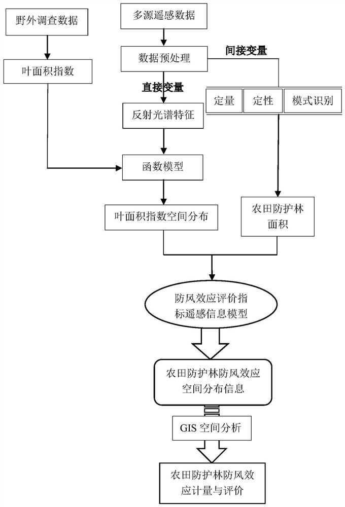
[0019] Specific implementation mode one: combine figure 1 This embodiment will be described. A method for measuring the windproof effect of farmland shelterbelts based on spatial information technology described in this embodiment, the method is specifically implemented through the following steps:

[0020] Step 1, collecting farmland shelterbelt remote sensing images, performing remote sensing data preprocessing on the collected remote sensing images, and obtaining farmland shelterbelt surface albedo image data;

[0021] Step 2. Use pattern recognition to extract farmland shelterbelt data from the obtained surface reflectance image data, and perform qualitative and quantitative analysis on the extracted farmland shelterbelt data, obtain the structural parameters of farmland shelterbelt, and calculate according to the obtained farmland shelterbelt structure parameters The area of ​​farmland protection forest;

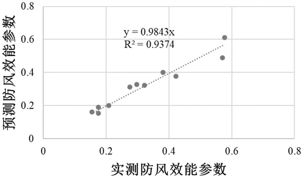
[0022] Step 3, using the reflectance spectrum characteristics of...

specific Embodiment approach 2

[0031] Specific embodiment 2: The difference between this embodiment and specific embodiment 1 is that the remote sensing image of the farmland shelterbelt is collected, and the remote sensing data is preprocessed on the collected remote sensing image. The preprocessing method includes radiation calibration, atmospheric correction and geometric correction. .

specific Embodiment approach 3

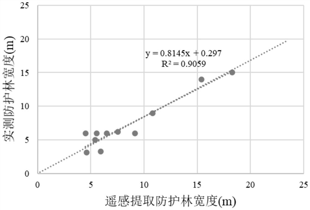
[0032] Embodiment 3: This embodiment differs from Embodiment 2 in that: the acquisition of the structural parameters of the farmland shelterbelt includes the length of the farmland shelterbelt and the width of the farmland shelterbelt.


PUM


Abstract

The invention relates to a method for measuring the windproof effect of farmland shelterbelts based on spatial information technology, which belongs to the technical field of farmland shelterbelt planning. The invention solves the problem that the current evaluation of the windbreak efficiency of farmland shelterbelts is not accurate enough, and the evaluation results are not suitable for guiding the design of shelterbelts. The invention uses spatial information technology, makes full use of the multi-spatial scale and multi-time scale characteristics of remote sensing, and combines remote sensing and geographic information system technology to realize the rapid evaluation of the windproof efficiency of farmland shelterbelts, and at the same time improves the evaluation accuracy of farmland shelterbelt windproof efficiency, ensuring the accuracy of the evaluation. It is found through experiments that the prediction accuracy of the present invention for the windproof efficiency index of farmland shelterbelts can reach 91.86%. According to the evaluation results, it can be judged whether the spatial allocation of shelterbelts is reasonable, and provide guidance for the government and shelterbelt construction departments. The invention can be applied to the planning of farmland protection forests.

Description

technical field [0001] The invention belongs to the technical field of farmland shelterbelt planning, and in particular relates to a method for measuring the windproof effect of farmland shelterbelts based on spatial information technology. Background technique [0002] Shelter forest is an important part of farmland ecosystem and plays an important role in farmland ecosystem. The density of shelterbelts and the spatial configuration pattern of shelterbelts determine their ability to protect farmland vegetation and directly affect their windbreak and sand-fixing capabilities for basic farmland. [0003] At present, domestic and foreign methods for evaluating the windbreak efficiency of farmland shelterbelts are mainly based on laboratory simulations or field observations. For example, wind tunnel tests or computer numerical simulations are used to analyze the windproof performance of shelterbelts. Or analyze the windproof performance of shelterbelts through field observati...

Claims


Application Information

Patent Timeline
Patent Type & Authority Patents(China)
IPC IPC(8): G01N21/84
CPCG01N21/84
Inventor 杨曦光于颖舒展范文义
Owner NORTHEAST FORESTRY UNIVERSITY
Why Eureka
Try Eureka