Ancient lake water depth quantitative reduction method

A kind of lake water and lake technology, applied in the field of oil and gas exploration, can solve the problems of lack of research on scientific problems, the depth of ancient lakes, and the lack of accuracy, so as to achieve clear thinking and innovation, strong practicality and promotion, and comprehensive enhancement Effect

Active Publication Date: 2020-08-25
陕西工业职业技术学院
View PDF5 Cites 3 Cited by
  • Summary
  • Abstract
  • Description
  • Claims
  • Application Information

AI Technical Summary

Problems solved by technology

Although in a small number of studies, the range of changes in paleo-depth has been qualitatively or semi-quantitatively restored through indicators reflecting paleo-depth (such as sedimentary facies, geochemical parameters, seismic data, numerical simulation, paleontology, etc.), such as Chinese patent CN103345001A involving a A method for measuring the water depth of ancient lakes. Through drilling and logging data, the thickness of individual sand bars is read, and finally the thickness of individual sand bars is summed to obtain the water depth of ancient lakes; Chinese patent CN104932031A relates to a method for lacustrine deposition The quantitative calculation method of ancient water depth, which screens out lakes similar to today, fits the quantitative relationship between organic matter content and water depth, and inversely deduces the ancient water depth of lakes by testing the organic matter content of drilling core samples; Restoration of paleowater depth during the shrinking period of the basin—taking the southern end of the Bodong low salient as an example", involves the restoration of the water depth at the southern end of the Bodong low salient through elemental geochemistry, stratigraphic spectrum attribute trend analysis, and micropalaeontology. There is still a lack of fineness and accuracy in restoring the water depth of ancient lakes. Overall, there is still a lack of research on scientific issues such as quantitative reconstruction of ancient water depths or the temporal and spatial evolution of ancient water depths.

Method used


Image

  • Ancient lake water depth quantitative reduction method
  • Ancient lake water depth quantitative reduction method
  • Ancient lake water depth quantitative reduction method

Examples


Embodiment Construction

[0014] The following will clearly and completely describe the technical solutions in the embodiments of the present invention with reference to the drawings in the embodiments of the present invention. Based on the embodiments of the present invention, all other embodiments obtained by persons of ordinary skill in the art without making creative efforts belong to the protection scope of the present invention.

[0015] Such as Figure 1 to Figure 7 As shown, a method for quantitative restoration of ancient lake water depth, the specific implementation steps are as follows:

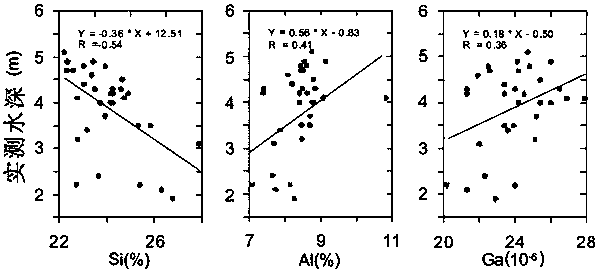
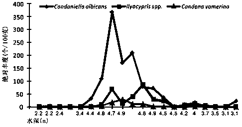
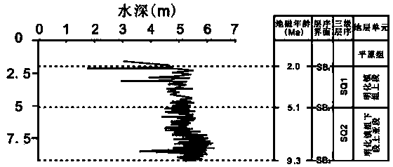
[0016] Step 1. Collect and collect geological data and geophysical prospecting data in the research area, analyze the structural and sedimentary evolution in the area, and combine refined seismic interpretation to comprehensively determine the sedimentary environment of the target layer, and clarify the planar shape, geomorphic unit, and climate environment of the ancient lake , water environment and other...


PUM


Abstract

The invention relates to an ancient lake water depth quantitative reduction method which comprises the following steps: establishing a quantitative relation between geochemical elements and actual lake water depth through a modern lake investigation means and lake bottom surface mudstone collection and analysis, and optimizing an optimal element of a fitting formula; meanwhile, inheritance and comparability of organisms are fully utilized, the water depth environment in which the organisms live serves as a link for determining environmental variable parameters between a modern lake and an ancient lake, and then a computational formula for restoring the water depth of the ancient lake is quantitatively reconstructed; in order to verify the accuracy of quantitatively restoring the paleo-water depth, the relative paleo-water depth restored by the sand-to-soil ratio method and the Fischer diagram method is compared with an agaricus bisporus climate change curve, the verification result shows that the change trend is kept consistent, and the reasonability and effectiveness of the method are proved.

Description

technical field [0001] The invention belongs to the field of oil and gas exploration, in particular to a method for quantitatively restoring ancient lake water depth. Background technique [0002] Large-scale oil and gas exploration in my country's offshore basins began in the late 1970s. With the unremitting efforts of Chinese geologists, the possibility of the formation of continental oil and gas reservoirs was proposed, which opened the prelude to the discovery of many large oil and gas fields. Among them, Daqing The discovery of oil fields confirmed this theory. However, the theoretical issues of continental oil generation are essentially inseparable from the study of paleolimnology. Factors such as lake type, lake productivity, and water body properties are the main controlling factors that determine the development of source rocks in oil-bearing basins. The focus of sedimentology research is directly related to the evaluation and prediction of conditions such as source...

Claims


Application Information

Patent Timeline
Patent Type & Authority Applications(China)
IPC IPC(8): G01V11/00
CPCG01V11/00
Inventor 赵春晨
Owner 陕西工业职业技术学院
Why Eureka
Try Eureka