A method for updating the loading area map applied to automatic driving in open-pit mines

A map update and automatic driving technology, which is applied in database update, navigation computing tools, structured data retrieval, etc., can solve the problem of high cost, difficulty in adapting to positioning and path planning requirements, and difficulty in updating high-precision maps in open-pit mine scenarios. Update requirements and other issues to achieve the effect of reducing computing power requirements and communication pressure, improving the efficiency of automatic driving, and reducing the probability of manual intervention

Active Publication Date: 2022-03-04
BEIJING EACON TECH CO LTD +1
View PDF0 Cites 0 Cited by
  • Summary
  • Abstract
  • Description
  • Claims
  • Application Information

AI Technical Summary

Problems solved by technology

The existing high-precision map update methods are mostly oriented towards the relatively regular high-precision map road network of the city. The update of the regional map is based on the active collection of the collection vehicle and the reporting of the terminal vehicle. The update efficiency is difficult to meet the rapid update requirements of the open-pit mine scene.
For example, some technical solutions are based on the detection and update of high-precision maps by road passenger vehicles, but this solution is difficult to apply to the positioning and path planning requirements of the open area loading area in open-pit mining areas where the update frequency reaches minutes or even seconds; or based on high-precision trajectories The data is combined with pure image data to measure and draw lane lines, but this solution is difficult to apply to mine roads without lane line marks; there are also technical solutions based on mining scene collection point cloud data, making point cloud layers, editing, marking roads, obstacles, High-precision map layers such as traffic rules are costly and inefficient, and it is difficult to meet the automatic update requirements of fast-changing terrain areas such as loading areas

Method used


Image

  • A method for updating the loading area map applied to automatic driving in open-pit mines
  • A method for updating the loading area map applied to automatic driving in open-pit mines

Examples


Embodiment Construction

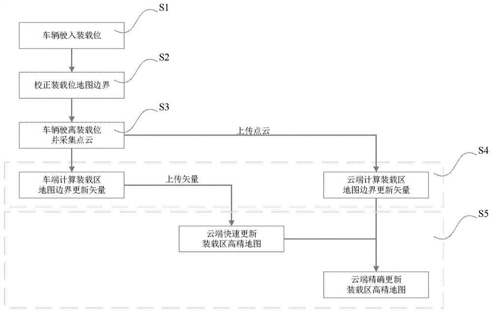
[0044] The present disclosure provides a method for updating a loading position area map applied to automatic driving in an open-pit mine.

[0045] In order to make the purpose, technical solutions and advantages of the present disclosure clearer, the present disclosure will be further described in detail below in conjunction with specific embodiments and with reference to the accompanying drawings.

[0046] Certain embodiments of the present disclosure will be described more fully hereinafter with reference to the accompanying drawings, in which some but not all embodiments are shown. Indeed, various embodiments of the disclosure may be embodied in many different forms and should not be construed as limited to the embodiments set forth herein; rather, these embodiments are provided so that this disclosure will satisfy applicable legal requirements.

[0047] In an exemplary embodiment of the present disclosure, a method for updating a loading location area map applied to autom...


PUM


Abstract

The present disclosure provides a method for updating a loading location area map applied to automatic driving in open-pit mines, including: controlling the vehicle to drive into the loading location according to the route planning route; Collecting the point cloud data of the loading site area during the process of leaving the loading site, wherein the loading site area is an area within a predetermined range from the loading site boundary; calculating an update vector of the loading site area map boundary based on the point cloud data; The high-precision map of the loading location area is updated by using the update vector of the map boundary of the loading location area. The disclosed method can adapt to the business scenario of high-frequency map boundary update in the loading area, and realize real-time and accurate update of the boundary of the loading area.

Description

technical field [0001] The present disclosure relates to the field of automatic driving, and in particular to a method for updating a loading position area map applied to automatic driving in open-pit mines. Background technique [0002] Due to its relatively closed and open environment, open-pit mines are one of the best choices for the implementation of autonomous driving technology. The key technologies of autonomous driving involve environmental perception, high-precision positioning, decision-making and planning, and execution control. Among them, high-precision Due to its high precision, high granularity, and real-time characteristics, maps can perform functions such as high-precision positioning, auxiliary perception, planning, and decision-making in autonomous driving, ensuring efficient and accurate path planning and safe driving. [0003] Different from the high-precision maps of traditional urban areas, the geographical elements of open-pit mines have been in the ...

Claims


Application Information

Patent Timeline
Patent Type & Authority Patents(China)
IPC IPC(8): G06F16/23
CPCG01C21/20G01C21/32
Inventor 王方建盛佳良王大伟张磊
Owner BEIJING EACON TECH CO LTD
Why Eureka
Try Eureka