A cloud service-based spatial big data management method and system
What is AI technical title?
AI technical title is built by Patsnap AI team. It summarizes the technical point description of the patent document.
A spatial data and data management technology, applied in the field of big data management, can solve problems such as inaccurate classification and insecure storage of spatial data, and achieve the effect of improving security
Active Publication Date: 2020-12-29
安徽宇呈数据技术有限公司
View PDF7 Cites 0 Cited by
Summary
Abstract
Description
Claims
Application Information
AI Technical Summary
This helps you quickly interpret patents by identifying the three key elements:
Problems solved by technology
Method used
Benefits of technology
Problems solved by technology
[0005] The embodiment of the present application provides a cloud service-based spatial big data management method and system, which solves the technical problems of insecure spatial data storage and inaccurate classification in the prior art, and improves the security of spatial data storage. The technical effect of accurately classifying and storing the spatial data
Method used
Image
Click on the blue label to locate the original text in one second.
Reading with bidirectional positioning of images and text.
Examples
Embodiment 1
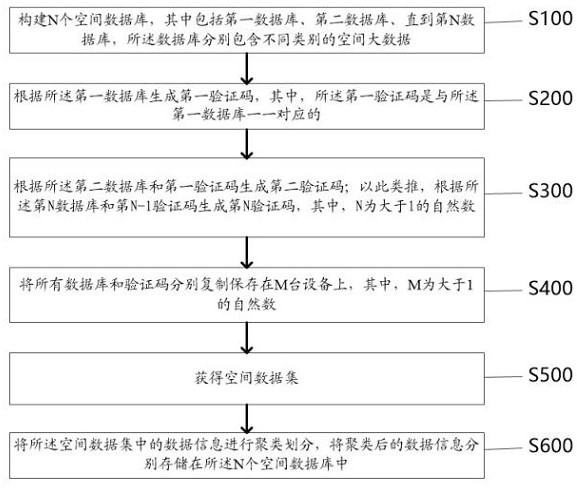
[0029] Such as figure 1 As shown, the embodiment of the present application provides a cloud service-based spatial big data management method, wherein the method includes:
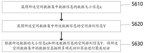
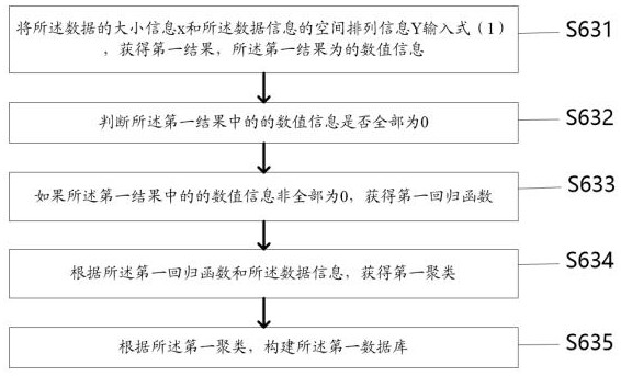
[0030] Step S100: Construct N spatial databases, including the first database, the second database, and up to the Nth database, each of which contains different types of spatial big data;
[0031] Specifically, the spatial database refers to a database storing spatial data, and N storage databases are constructed, wherein N is a natural number greater than 1. Each of the N databases stores different types of spatial big data information.
[0032] Step S200: Generate a first verification code according to the first database, wherein the first verification code is in one-to-one correspondence with the first database;
[0033] Specifically, the verification code is a unique identification code used to verify the database. Perform hash function calculation according to the first database to generate a first...
Embodiment 2
[0086] Based on the same inventive concept as the cloud service-based spatial big data management method in the foregoing embodiments, the present invention also provides a cloud service-based spatial big data management system, such as Figure 7 As shown, the system includes:
[0087] The first construction unit 11, the first construction unit 11 is used to construct N spatial databases, including the first database, the second database, until the Nth database, and the databases respectively contain different categories of big spatial data;
[0088] A first obtaining unit 12, the first obtaining unit 12 is configured to generate a first verification code according to the first database, wherein the first verification code is in one-to-one correspondence with the first database;
[0089] The second obtaining unit 13, the second obtaining unit 13 is used to generate a second verification code according to the second database and the first verification code; and so on, generate ...
PUM
Abstract
The invention discloses a cloud service-based spatial big data management method and system. The method includes: constructing N spatial databases, including the first database, the second database, up to the Nth database, and the databases respectively contain different category of spatial big data; generate a first verification code according to the first database, wherein the first verification code is in one-to-one correspondence with the first database; generate according to the second database and the first verification code The second verification code; by analogy, generate the Nth verification code according to the Nth database and the N-1 verification code, and copy and save all databases and verification codes on M devices respectively to obtain a spatial data set; The data information in the above spatial data set is clustered and divided, and the clustered data information is stored in the N spatial databases respectively, so as to improve the security of spatial data storage and accurately classify and store the spatial data. Effect.
Description
technical field [0001] The invention relates to the field of big data management, in particular to a cloud service-based spatial big data management method and system. Background technique [0002] The rapid development of the mobile Internet has brought human beings into the era of location big data. More and more location-based services (Location Based Services, LBS) are integrated into people's daily life, providing services such as point-of-interest query, real-time location sharing on social networks, route planning and navigation, etc., which provide great convenience for people. The safe sharing and release of big data on location and trajectory cannot be separated from the technical support of location and trajectory privacy protection. [0003] However, in the process of realizing the technical solution of the invention in the embodiment of the present application, the inventor of the present application found that the above-mentioned technology has at least the fo...
Claims
Application Information
Patent Timeline
Application Date:The date an application was filed.
Publication Date:The date a patent or application was officially published.
First Publication Date:The earliest publication date of a patent with the same application number.
Issue Date:Publication date of the patent grant document.
PCT Entry Date:The Entry date of PCT National Phase.
Estimated Expiry Date:The statutory expiry date of a patent right according to the Patent Law, and it is the longest term of protection that the patent right can achieve without the termination of the patent right due to other reasons(Term extension factor has been taken into account ).
Invalid Date:Actual expiry date is based on effective date or publication date of legal transaction data of invalid patent.

