Three-dimensional stratum modeling method based on geological map tangent section

A technology of three-dimensional strata and modeling method, which is applied in the field of three-dimensional stratum modeling based on geological map cut sections, can solve problems such as complex contour correspondence, and achieve the effects of high modeling accuracy, reduced workload, and easy control

Active Publication Date: 2020-11-20
CHENGDU UNIVERSITY OF TECHNOLOGY +2
View PDF9 Cites 8 Cited by
  • Summary
  • Abstract
  • Description
  • Claims
  • Application Information

AI Technical Summary

Problems solved by technology

[0043] Aiming at the problems existing in the existing modeling methods, the present invention provides a three-dimensional stratum modeling method based on geological map cut-sections, which combines grid modeling and geological model surface reconstruction, and avoids complex contours Correspondence, triangulation network connection and other issues, and can obtain a high-precision 3D vector geological model; and also solve the sampling accuracy and data volume in the modeling process, the calculation of the 3D data field by the global interpolation method, and the accuracy of isosurface extraction, etc. question

Method used


Image

  • Three-dimensional stratum modeling method based on geological map tangent section
  • Three-dimensional stratum modeling method based on geological map tangent section
  • Three-dimensional stratum modeling method based on geological map tangent section

Examples


Embodiment

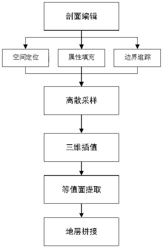
[0121] 1. Edit the graph cut section

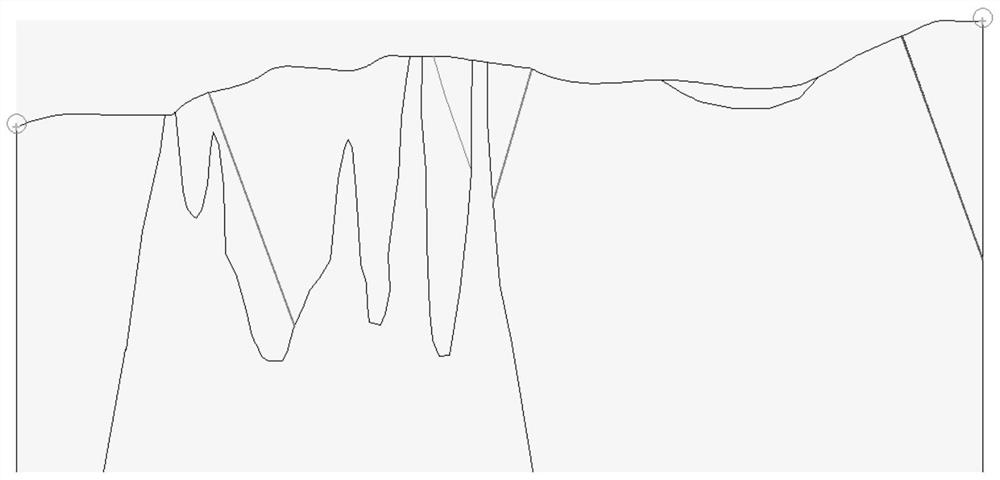
[0122] figure 2 It shows a schematic diagram of a graph cut section, and supports vector graphic formats (such as DXF) or raster graphic formats (JPG, GIF, BMP, etc.). Editing of graph cut section includes the following steps:

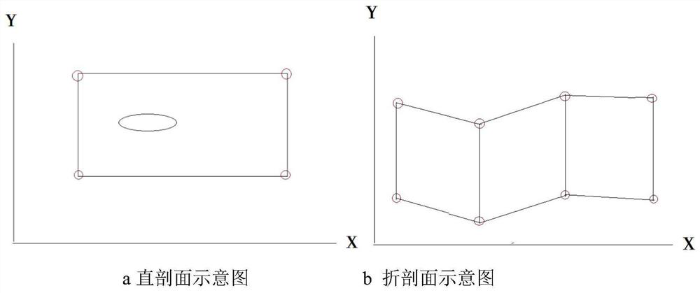
[0123] (1) Load the DXF graph cut section graphics, select four corner points on the graph cut section (at least 2 anchor points are required), and set the three-dimensional space coordinates of the four corner points, and map the graph cut section to space in the coordinate system. The present invention supports a straight section or a graph-cut section of a folded section. The straight section means that the straight line is used to make the graph cut section when making the graph cut section, and the folded section means that the graph cut section is made by using broken lines to make the graph cut section. The spatial positioning point corresponding to the folded section shall be marked on the turning poi...


PUM


Abstract

The invention discloses a three-dimensional stratum modeling method based on a geological map-cut profile. The method comprises the steps: S1, editing the map-cut profile, and completing the setting of basic parameters needed by modeling; s2, discrete sampling is conducted on the stratum boundary and the inner and outer areas, and discrete distribution of stratum attributes in space is obtained; s3, performing interpolation calculation on the stratum three-dimensional space discrete points to generate a three-dimensional space stratum attribute data field; s4, contour surface extraction is carried out from the three-dimensional space stratum attribute data field, and a three-dimensional contour surface of the stratum is obtained; s5, repeating the steps S2 to S4 to obtain three-dimensionalcontour surfaces of all stratums; s6, spatial splicing is conducted on the surfaces of the three-dimensional contours of all the stratums, and three-dimensional stratum modeling is completed. According to the method, the problems of complex contour matching, bifurcation, corresponding triangulation network connection and the like in a two-dimensional contour reconstruction method are avoided, anda high-precision three-dimensional vector geologic model can be obtained; the method is suitable for stratum modeling under any complex condition, the modeling efficiency is high, and the applicationrange is wide.

Description

technical field [0001] The invention relates to the fields of geology, mineral resources and engineering, in particular to a three-dimensional stratum modeling method based on cut sections of geological maps. Background technique [0002] 3D geological modeling has always been a technical hotspot and difficult issue in the research of engineering, geology, and mining industries. Restoring the underground geological structure and petrophysical parameters through limited geological data plays a very important role in engineering geological analysis, oil and gas and mineral exploration and development. Due to the diversity and multiple solutions of geological data and the limited means of data acquisition, 3D geological modeling is difficult and the implementation process is complicated. Among them, 3D geological modeling using geological map cut sections is a common modeling method. [0003] Map-cut section modeling is to draw a series of parallel (or nearly parallel) sectio...

Claims


Application Information

Patent Timeline
Patent Type & Authority Applications(China)
IPC IPC(8): G06T17/05G06T17/20G06T3/40
CPCG06T17/05G06T17/205G06T3/4023
Inventor 简兴祥王丽坤钟红梅李宏涛罗海金袁宏马婵华姚华龙叶娇珑
Owner CHENGDU UNIVERSITY OF TECHNOLOGY
Why Eureka
Try Eureka