A method, device and system for life cycle tracking and dynamic prevention and control of geological disasters

A geological disaster and life cycle technology, applied in the field of image recognition and geological disaster monitoring, can solve problems affecting people's lives and property safety, unable to prevent geological disasters, losses, etc., so as to reduce or avoid the loss of people's lives and property safety. , the effect of improving timeliness, reducing or avoiding losses

Active Publication Date: 2022-02-08
深圳市易智博网络科技有限公司
View PDF0 Cites 0 Cited by
  • Summary
  • Abstract
  • Description
  • Claims
  • Application Information

AI Technical Summary

Problems solved by technology

[0004] However, the existing technology cannot prevent geological disasters, so that when geological disasters occur, the lives and property safety of the masses will still be affected, and losses will be caused.

Method used


Image

  • A method, device and system for life cycle tracking and dynamic prevention and control of geological disasters
  • A method, device and system for life cycle tracking and dynamic prevention and control of geological disasters
  • A method, device and system for life cycle tracking and dynamic prevention and control of geological disasters

Examples


Embodiment 1

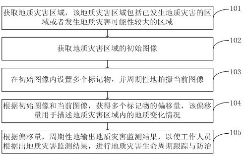
[0069] The embodiment of the present invention provides a method for tracking the life cycle of geological disasters and dynamic prevention and control, referring to figure 1 As shown, the method includes:

[0070] 101. Obtain a geological disaster area, where the geological disaster area includes areas where geological disasters have occurred or areas where geological disasters are likely to occur.

[0071] Specifically, according to the area to be monitored input by the user through the terminal;

[0072] According to the current meteorological data and historical records of geological disasters, the geological disaster area is determined from the area to be monitored.

[0073] 102. Acquire the initial image of the geological disaster area.

[0074] Specifically, the step of obtaining the initial image of the geological disaster area is realized by any one of the following methods:

[0075] Obtain real-time real-time map data of geological disaster areas, and process the ...

Embodiment 2

[0084] An embodiment of the present invention provides a method for tracking and dynamic prevention and control of geological disaster life cycle, the method includes:

[0085] 201. According to the area to be monitored input by the user through the terminal.

[0086] Specifically, the area to be monitored input by the user through the terminal can be:

[0087] Obtain the range selected by the user through gestures on the map interface;

[0088] Identify all mountains and slopes within this range, and display all mountains and slopes, so that users can confirm all mountains and slopes. The above identification process can be obtained through the map data of this range. The embodiment of the present invention is specific to the identification The method is not limited. or,

[0089] Get the coordinates entered by the user;

[0090] Identify the mountains and slopes located at the coordinates, or the mountains and slopes closest to the coordinates, and display all the mountai...

Embodiment 3

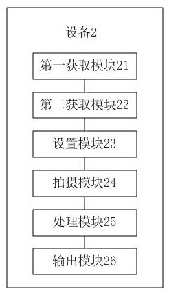
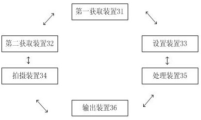
[0134] The embodiment of the present invention provides a kind of equipment 2 for geological disaster life cycle tracking and dynamic prevention and control, refer to figure 2 As shown, the device 2 includes:

[0135] The first acquisition module 21 is used to acquire geological disaster areas, and the geological disaster areas include areas where geological disasters have occurred or areas where geological disasters are likely to occur;

[0136] The second acquisition module 22 is used to acquire the initial image of the geological disaster area;

[0137] A setting module 23, configured to set a plurality of markers in the initial image;

[0138] A photographing module 24, configured to periodically photograph the current image;

[0139] The processing module 25 is used to obtain the offset of multiple markers according to the initial image and the current image, and the offset is used to describe the geological changes in the geological disaster area;

[0140] The output...


PUM


Abstract

The invention discloses a method, device and system for geological disaster life cycle tracking and dynamic prevention and control, belonging to the fields of image recognition and geological disaster monitoring. By comparing the initial image and the current image of the geological disaster area, the monitoring of the geological disaster area is realized, thereby realizing the prevention of geological disasters, reducing or avoiding the loss of people's lives and property safety. Through the periodic output of geological disaster monitoring results, real-time monitoring of geological disaster areas is realized, which not only realizes the prevention of geological disasters, reduces or avoids the loss of people's lives and property safety, but also further improves the timeliness of geological disaster prevention sex. By monitoring the areas with high possibility of geological disasters, it not only realizes the prevention of geological disasters, reduces or avoids the loss of people's lives and property safety, but also further improves the accuracy of geological disaster prevention.

Description

technical field [0001] The invention relates to the fields of image recognition and geological disaster monitoring, in particular to a method, device and system for life cycle tracking and dynamic prevention and control of geological disasters. Background technique [0002] Geological disasters, especially geological disasters such as landslides, landslides and mudslides, are occurring more and more frequently under the circumstances of abnormal climate, seriously affecting the lives and property safety of the masses, thus requiring a geological disaster prevention and control system methods to reduce the losses caused by geological disasters. [0003] The existing prevention and control of geological disasters is often the transfer of property and personnel after the disaster occurs, so as to reduce the further damage of geological disasters to people's lives and property safety. [0004] However, existing technologies cannot prevent geological disasters, so that when geol...

Claims


Application Information

Patent Timeline
Patent Type & Authority Patents(China)
IPC IPC(8): G06V20/13G06V10/22G06Q50/26G08B21/10
CPCG06Q50/26G08B21/10G06V20/13G06V10/235G06V10/22
Inventor 霍超能朱隆星欧金凤
Owner 深圳市易智博网络科技有限公司
Why Eureka
Try Eureka